Saturday, January 29, 2022

Rockd by Walnut Hills

This is going to sound like an advertisement...consider it a recommendation.

Rockd by The Mactostrat lab at the Geoscience department at the University of Wisconsin - Madison is one of my main tools for geological exploration. It's an app on my smartphone. 

Where most geology apps are reference works, like geology textbooks or encyclopedias on your phone, Rockd is equipment. It includes a Brunton compass and information about localities with topographic and geological maps and geology and paleontology profiles. It's pretty impressive how much local information it packs. (The Brunton compass needs a gyroscope and magnetometer to work.)

Let's see what it says about my backyard, Walnut Hills in Centennial, Colorado.

When I open Rockd, I see this, my dash board.

It gives me an overview of my area. 

People that don't live here often mistake Denver for a mountain town. It may be a gateway to the Rockies but it's situated at the western edge of the Great Plains. It's hilly grasslands.

Specifically, Centennial, a town in the Denver metro area, is near the western edge of the Colorado Piedmont region. 

Denver makes a big deal about being the Mile High City but, actually, it's down in a hole carved by the South Platte River. Just about everyone around us is at higher elevations.

We're sometimes called the "high plains" but, technically, the high plains are to the east of us. As explained by Rockd, when I tap the Colorado Piedmont panel, the high plains were formed when the Colorado Plateau was pushed up when the Pacific plate crashed into (and is still crashing into) North America. The Rockies are still growing but erosion is happening faster and the craggy appearance of the Rocky Mountains is due to the deep cutting of millions of years by rain, frost, wind, and chemical action. All the debris that washed out of the mountains piled up to form the high plains, and then streams running from the mountains started cutting the softer sediment down to form the Colorado Piedmont.

How old is the rock around here? Rockd says 0.0117 mA (that stands for "mega annum" or million years) to present. This is fairly new stuff. The late pleistocene began 0.02 million years ago and the Quaternary is the most recent age of geologic time. You probably know that the continents have shifted around a lot in the past. Here's what Rockd says the World looked like in the Quaternary age.


Same as today. Really new stuff.

The colluvium mentioned is "generally unconsolidated material deposited on slopes by gravity and sheetwash". (The original source sited is Trimble, D.E., M.N. Machette, 2003, Geologic Map of the Greater Denver Area, Front Range Urban Corridor, Colorado: U.S. Geological Survey Geologic Investigations Series 1-856-H.

(If I poke the citation, Rockd carries me to the actual paper.)

The layer of colluvium is generally more than 1.5 meters thick. Mind you, that's our bedrock. Above that is the regolith. Regolith is the term for the bedrock after it rots. We have a lot of debris under our feet..

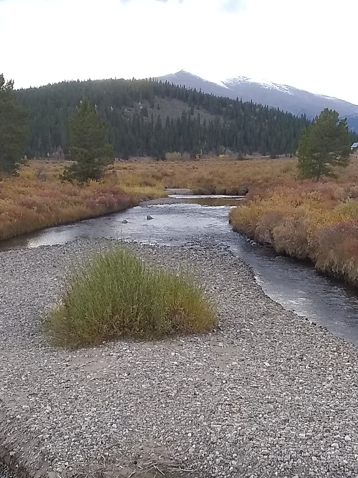
It's sort of hard to tell if the stuff in the Little Dry Creek stream bed is native or if it was placed there to slow erosion, or if it has been washed down from architectural fill upstream, but it could easily be part of the colluvium washed out of the mountains long ago. Some of that is pretty chunky.

So, we're at 5732 feet. Littleton is right on the river at 5351 feet. We're situated right at the top of the rim of the South Platte River valley, which makes the valley 381 feet deep here. The river comes out of the mountains due west of both us and Littleton at Waterton Canyon. Water flows downhill so Denver, through which the South Platte flows is lower in elevation at 5130 feet (Wikipedia says 5139-5690 feet but that would be the whole Denver metro area.)

Here's a geologic map of the area from Rockd.

The lighter stuff is the colluvium I've been talking about. The darker is Dawson formation which is an older Late Cretaceous to Paleocene rock...100.5-56 million years old. It might be worth visiting the next neighborhood over to see if Willow Creek digs into that sandstone.

Most of the fossils listed in this area are nearer the bottom of the river valley, so I don't expect to find any in this neighborhood (though I will look for some microfossils in the creek bank), also most of the minerals will be clays and quartz since most of the other stuff would have broken down long ago.

Rockd is a free download, so install it and see what it has to say about your area. You might be surprised.

Walnut Hills

Be forewarned that geology, like astronomy, and paraphrasing Gershwin, is a sometimes thing. Weather, hydrology, and economic factors and play havoc with your plans. That said, I always encourage lifelong learners to explore close to home first. That's the easiest and most accessible focus and everyplace is interesting.

My geology laboratory will be the Little Dry Creek valley in the Walnut Hills neighborhood in Centennial, Colorado. I have been assured that there is, in fact, not a single walnut tree in Walnut Hills. Also, I have never seen Little Dry Creek without water flowing through it. And it is "little" not because of it's size. It was named after the same engineer from New Hampshire, Richard Sullivan Little, that Littleton, Colorado was named after. Little settled in the area with his family in 1862. The town of Littleton is about 15 miles due west of Walnut Hills.

Two creeks have sculpted the Walnut Hills area, Little Dry Creek and Willow Creek. The soil is deep and soft so the creek valleys are fairly deep and steep. They are tributaries of the much larger South Platte River valley in which the Denver metro area is located.

This is a view of Little Dry Creek from Uinta Street in the Walnut Hills neighborhood where it flows behind Walnut Hills Elementary School. The hilliness is directly due to the erosive action of the creek.

The creek begins as runoff from the area just east of Walnut Hills and is tracked by the Little Dry Creek Trail, part of the Centennial Connector Trail, which parallels it throughout the neighborhood. I take the trail often on trips to the several shops in the area, so I have plenty of opportunities to study the area.

In general, road cuts, newly graded dirt roads and other architectural features that clear dirt off the rock below are a geologist's friend...not necessarily here.

It is an urban area, which means that I will have to be careful to distinguish between the actual geology and landscaping. Granite is not indigenous to this area so the rocks in the above photo were brought in. Here is a picture of the natural materials that inhabit the area.

The dirt and mud goes pretty deeply.

That doesn't sound too interesting, geologically, but I think you'll find that not to be the case. The place in the photo is at the western border of the neighborhood and is the only place on Little Dry Creek that shows a well defined soil profile, so I will certainly be coming back here.

On a walk down the trail to a local grocery, I used my AllTrail app to get an idea of the shape of the valley. I started at the eastern border of the neighborhood and walked to the western border. Here's the map and elevation profile.

Over 1.2 miles, the creek drops about 130 feet. Of course, this is the elevation profile of the trail, but the trail begins and ends at close to the elevation of the creek. The grade is pretty much linear. The hump at mile 0.6 is where the trail runs up the shoulder of the valley above the creek. 

On the return trip, I walked up the main road and cut down Uinta for a cross section of the valley down from the rim. Here's an elevation profile of that.

I'll take some other cross sections later. Of course, they change from the top of the valley to the bottom. There are five places that roads cross the creek on the neighborhood. 

Notice above that AllTrails provides topographic maps. The gray lines in the above maps are contours. Google Maps, Google Earth and the Rockd app also gives you topographic maps. When hiking, a topographic map is important. When exploring the geology of an area, they are necessary. A topographic map shows you the shape of the land.

Rockd also provides geological maps of areas. Those show you the kind of rocks and history of an area. I'll look at what the Rockd app has to tell me about Walnut Hills in the next blog.

It's possible that you have been walking around your home territory for years without considering what's under your feet. The next time you're out, look around and ask yourself how the land became the way it is. What were the shaping forces? What are the rocks and dirt like and why are they like that?

Friday, January 14, 2022

Wolf on the rocks

Here's my "backyard".
That's the Rockies in the distance. Little Dry Creek carves a nice valley down from this point. One of the sources is a marshy area across Yosemite, here:
When I walk to the top of the rise to the east, I see this:
a different world with an actual horizon.

This area is a geotourism dream...the Rockies with canyons cutting into their granitic hearts, rich paleontological sites, ancient volcanoes weathered down to their basaltic innerds, carved sedimentary bluffs. I am fortunate to live in this area.

But, y'know. Everywhere I have ever lived has been geologically fascinating. Earth is geologically fascinating.

My earliest hobby was mineral collecting. When I was three, my family moved to Lagrange, Georgia, built over a gem rich pegmatite lens. My father and I visited a quarry about five miles outside the city and we knew nothing of the "space age" minerals that were being mined there so we picked up a couple of chunks of pretty rose quartz after googling at the towering walls of rock and then we left.

Years later, a couple if guys broke into the site late at night with a pickup truck and jack hammer. The owners closed the quarry to the public. From then on, the rock was crushed and sold as land fill. The site has produced beryls the size of barrels. Some are in the Smithsonian. Garnets, rutiles, tourmalines abound there...to be crushed and used as land fill 

We went back many years later and picked around the sides of the highway. Just before I moved to Colorado, after my father had died, the site opened back up to the public.

I didn't see much of my father during my childhood. He had to work (a lot) to support our family. (I didn't realize until much later how truly poor we were. Dad did a good job.) When I was in high school, he decided that we needed something we could do in common and his answer was mineral collecting. 

We spent a lot of time on the rocks. Any local construction project was fair game. Whenever we traveled, we looked for holes in the ground to explore. We connected with college professors and hermits that also collected.

Our personalities were different. He was meticulous, pouring over a single boulder on the dike of a dam, while I would start at one end and quickly traverse the granite, making a mental note of rocks I would revisit. But it tied us together. 

When he found out that he was dying of lung cancer, the last year and a half of his life involved joyously panning for gold and gems and chipping away at boulders.

Georgia intrudes into Alabama with a wedge of igneous and metamorphic rock that always delivers surprises. When I was ten, we moved from Lagrange to Valley, Alabama. During my high school years, we lived on a street that dead ended at a power line easement where I spent a lot of my free time. It was forested and sculpted by several small creeks. I once scooped some sand from one of the creeks for examination. When I got it home, I found that it was full of grains that glowed bright orange under my black light. When I looked at it under a microscope, I found sharp, octahedral crystals of thorite. Thorite isn't common.

I'm not crazy about fossils, but most of Alabama is fossil country. I was surprised though to find big, textbook quality crystals of pyrite popping out of the clayey banks of the Alabama River in Selma, where I lived for twenty years.

Alabama isn't known for it's ragged landscape. It's not known for the network of canyons that stretch across it's northern border or the waterfalls the dot the landscape from Lookout Mountain in the northeastern corner of the state to the forested area thirty miles north of the Gulf of Mexico. I was glad that it was an "undiscovered" outdoor paradise.

Geology is accessible but that's not the only thing that recommends it as a hobby. It's inexpensive. You don't really need much equipment to pursue it. Here's a list:

Small rock pick: has a hammer at one end and a pick at the other.

Chisel (or set of chisels) and rubber mallet.

Safety goggles: for when you make rock chips fly.

Small dropper bottle of dilute hydrochloric acid (or vinegar).

Small magnet.

Mohs Hardness Scale: either the nine mineral samples or common materials such as an iron nail, glass microscope slide, emery paper square, and your finger nail.

Magnifying glass

Freezer bags and tissue paper for specimens.

Something to carry it all in.

There are some incredible phone apps for geologists. In addition to the regular science stuff like Google maps (or Google Earth), Vieyra's Physics Toolbox, Walter Stubb's MC50 Programmable Calculator, and the Arduino Science Journal, check out Workshop512's Dioptra and University of Wisconsin Microstrat's Rockd, an all in one utility for geologists. The last app provides a major necessity for geological exploration...maps, both geological and topological. You can also poke an area on a map and it will give you the geological lowdown on the area. Definitely check it out!.

If you want to try something special, that's usually not too expensive either. Ultraviolet prospecting is a cool nighttime activity. A combination long and short wave ultraviolet light is available at Home Science Tools for less than $50. An added benefit is that scorpions and rattlesnakes also glow under a blacklight.

Earth is our home and it is exquisitely carved. Anyone can find adventure in their back yard.

Wednesday, December 29, 2021

My life with chemistry

Yep, I've been there, too.

As a child, my main recurring Christmas gift was a chemistry set. That was back when chemistry sets were "dangerous", with real chemicals that you could actually get to. I preferred the "experiments" that changed colors and exploded.

I once made a batch of gunpowder. My father was skeptical as to whether it would actually burn or not so he placed a little pile on the wooden floor in our walled-in back porch and lit it.

It burned.

In school, I was fond of labs. Show-and-tell was often a chemistry experiment. It often resulted in an evacuation.

In elementary school, I set up a demonstration of how crude oil was cracked to make different compounds. The science teacher did the actual demonstration. There was fire involved so they didn't let a little kid perform it. That would be dangerous.

I told him the tube was getting blocked. He didn't listen.

When it blew, the cork in the test tube hit a girl in the front row and knocked her out of her chair.

Oh, I continued my mayhem into college. I once spilled some concentrated hydrochloric acid on the floor of a class laboratory. The correct response is to neutralize the acid with a base and then wash the spot. My choice of base? Concentrated ammonia solution.

Unfortunately, the gases given off by ammonia solution and hydrochloric acid, ammonia and hydrogen chloride, will combine in air to form a white, solid, particulate substance, ammonium chloride.

Soon, I couldn't see a foot in front of my face. Another evacuation.

My first ten years at Auburn University was a five year curriculum in Pharmacy. I wanted it for the physiological background that I could take into a double major with psychology. I was interested in neurophysiology before neurophysiology was cool. But there was also a lot of chemistry to keep me happy. 

For the first ten years at Auburn (I spent twenty years there alternately studying and working my way through a double major and graduate school.) I variously commuted from home in Valley, Alabama and lived in a dormitory. I didn't drive, though. For awhile, I tagged along with a chemistry professor who lived in Valley. I paid for the lift working as his lab assistant. He collected amino acids, synthesizing one after another and determining their properties. There wasn't much color or explosions. There could have been explosions but I would have lost my ride.

But I did get to watch him run his tests and I washed a lot of glassware.

Occasionally, there was a class (for credit) that was basically students helping a professor with their project. I jumped on those.

It's been awhile since I've played around with chemicals. Chemicals for home exploration became scarce about the time I graduated from college. Blowing up buildings full of people became a thing and the only way you could order a laboratory grade chemical was if you had proof that you had some professional or occupational reason to have it. Chemistry sets became safe (lame). You couldn't actually get at the chemicals; you could only transfer them from one closed container to another. And even if you could get at them, they were all very dilute solutions and there was only enough to perform the "experiments" in the manual.

Things  have loosened up now and you can buy reasonable chemistry sets and individual chemicals online (for instance, from Home Science Tools) and, in larger cities, from local dealers who cater to hobbyists. 

I'm not sure how I want to approach chemistry next year. I don't want to rely too much on laboratory grade chemicals so as to keep close to the portable and inexpensive philosophy of the blog, but we can't really avoid some chemical purchases. It would also be hard to avoid some level of chemistry hardware - glassware, heating equipment, supports, those sorts of things, but all that tends to be pretty inexpensive.

Two resources I keep close are: 
and

They have a lot of the basic material at prices that adventurers can afford.

The blog is basically for introducing adventurers (including myself) to different fields. For more in-depth study, I am writing the LabBooks, and I do want to start one on Chemistry. Like the astronomy and physics LabBooks, they will be a long term project and I'll be working on very basic topics for a good while. But they'll be available at the Timeline as they progress.

In the meantime, have a fun and satisfying New Years Eve and New Years Day, and may all your future years be better than any that has gone before.

Sunday, December 26, 2021

Years


If you've been following this blog, you'll have noticed that I've slowed considerably. The pandemic has had a lot to do with that, along with...aging, I guess. But I'm still on the trails.

This last picture is appropriate. It's the National Mining Museum in Leadville, Colorado. It should be on the bucket list of anyone interested in geology. Housed in a retired high school, it displays everything mining and mineralogy.

A close friend wanted to drive to Vale to hike around this picture postcard tarn...

Despite two feet of snow, we finished early and decided to go into Leadville. Glacial topography and mining...a perfect lead-in to next year when I will segue from physics and astronomy to chemistry and geology, mostly geology because the Denver area is a geotourists dream.

I won't be leaving physics and astronomy behind. I'll keep working on the LabBooks, but my trail adventures will carry me from the margins of the Rockies into the mountains.

I'll be focusing on my back yard and I invite you to join me in exploring your own back yard. You might be surprised by what you find there.

And, as always, I wish for you a greater future than any that has gone before.

Sunday, October 24, 2021

The Mosquitoes

When I take a vacation, I devote all of my time to learning about new surroundings...

Wrong!

I enjoy myself, but learning is a part of that. I live within sight of the Rocky Mountains, but I don't get into them that often, so I appreciate what opportunities I get.

Some tribe members came down from Michigan to spend a week in the mountains and our House stayed with them.

The Mosquito Range separates Fairplay, Colorado from Breckenridge. Fact is, we saw one mosquito the whole week and, although Colorado has a diversity of biting flies, there aren't many mosquitoes. I found some of the history of the Mosquitoes here: 


But where the name came from...I haven't the foggiest.

The drive from Denver was spectacular, bringing us over Kenosha Pass, but we didn't see any of it because it was night and we were driving through storm clouds.. an adventure in itself. The mountains open up into one of the great high altitude valleys, called parks. Fairplay is in the northwest corner of South Park, and, yes, this is the South Park of television fame/infamy (according to how you like your comedy.) Our destination was in the mountains above Fairplay.

Colorado is tricky. If you were taken from some other part of the world and placed, blindfolded, near Denver, your eyes might tell you that you are somewhere near sea level. The ground is relatively flat. The mountains are right there to the west but an unobstructed view to the east would stretch far. Your lungs would tell you something else because the land actually slopes up from the Mississippi River, over 800 miles away, to Denver, and Denver is a mile over sea level, which means that there is less atmospheric pressure and oxygen.

Fairplay is similar except, ignoring how flat the ground is, Fairplay is almost 10,000 feet above sea level, and even people from Denver might have some difficulty breathing there (I did!)

The Mosquitoes are high peaks. In the twenty miles between Fairplay and Breckenridge are four fourteeners and several other summits above thirteen thousand feet. Our lodge was at a little over ten thousand feet. It was up the side of the valley over the middle fork of the same river that flows through Denver, the South Platte.

The first morning I was at the lodge, I just missed a herd of elk tramping across the property. I missed a lot, but my camera wasn't idle so I'll share what I managed to photograph.

Aspen and evergreens dominated the fall foliage. Aspens are closely related to poplars, in fact, the scientific name for the genus is populus. They like the cold but can survive the short Colorado summers. We have one in our back yard in Centennial.

They are rathers vicious. They secret a toxin that keeps undergrowth from around their roots, which spread out to form other trees. There is a grove of about twenty aspens uphill from the lodge. They are all one tree. Individual trees might live over 100 years but there is a colony in Utah that has a root system estimated to be 80,000 years old.

Crystal Lake Trail carried some of us a few hundred feet above Alma, Colorado, A small town in the Mosquitoes. Alma was getting some snow. We were in the clouds and were getting pelted by blocky, hexagonal crystals of ice called "graupel". We persevered.

We began our 4+ mile trek out in mountane forests of evergreen and aspens but the trees quickly shrank to bushes and brambles. This stuff was all over the place.

My companions asked what it was and I didn't know, so I took a picture and later subjected it to Google Lens. (Although the lodge had WiFi, there was no Internet where we were.) All the willows I had ever seen were trees but, in montane environments, they adapt to form these low, cottony bushes. We were taken by the aromatic leaves. 

Willows were one of the early sources of pain relieving salicylates. Modern aspirin is acetylsalicylic acid, but methyl salicylate is the aromatic ester in wintergreen and other salicylates smell good also. The reason for tagging the acetyl group onto salicylate is that the other compounds are rough on stomach linings. Nevertheless, if you have a pain, you can use willow bark or wintergreen tea to get some relief. Just don't overdo it.

We crossed the treeline at around 12,000 feet and none had passed out from a lack of oxygen. One of us was used to diving around the coast of North Carolina before joining us in Colorado and it seems to help. The rest of us were a little out-of-breath. Big trees need more air to thrive than shrubs so they like lower elevations.

Our destination, Crystal Lake (and, by the way, there are at least three Crystal Lakes between Fairplay and Breckenridge. It's easy to get confused.), resides in a scooped out depression in the side of the mountain. It's pretty obvious that there was once a glacier here. These glacial depressions are called "cirques" and the lakes are called "tarns".

What drew people to these mountains was gold that is washed out of the granite by streams and collected in gravels, the gold being heavier than the other stuff in the stream beds. It's called placer mining and the above photo was taken from a mound of rock left by a mining operation. It sloped down to a marshy area that had claimed a Jeep (?!?) and, then, the lake. This place is probably packed with wildflowers in the spring.

The mountains that form the eastern wall of the Rockies can be a scrabble of metamorphic, sedimentary, and igneous rocks, but the Mosquitoes are in the heart of the Rockies and all that has been scraped off by wind, rain, and lots of ice. These are granite mountains.

The Continental Divide runs through here. The waters of the South Platte, running through Fairplay, end up in the Mississippi River and continue to the Gulf of Mexico and, thus, to the Atlantic Ocean. The waters around Breckenridge drain into the Blue River, which is a tributary of the Colorado, so they end up in the Pacific Ocean (well, they would if they were not intercepted for drinking water and irrigation by folks west of here.)

The next day, a few of us walked down to the river below the lodge. Here, the valley carved out by the South Platte broadens as it approaches South Park, itself a wide valley swept out by the South Platte and it's tributaries. The rivers pours out of the hard granite of the Mosquitoes into softer sedimentary rocks of a faulted and folded bowl between the higher mountains. The softer rock allows the river to meander more and more.

The broken thunderstorms afforded us with a nice valley rainbow.

The area is surrounded by several of the local fourteeners, like Mt. Sherman.

It was gravel beds like these that drew pioneers to the area. The granite washed out of the mountains carried with it gold. 

These streams are not like the ones I'm used to back east...or the ones where I currently live at the edge of the Great Plains. Those streams have a thick bed of soft material to dig into. The ones in the Rockies meet hard bedrock quickly so their beds tend to be shallow with vertical shoulders.

That night, I pulled out several scopes to look at the sky. The first few days were too cloudy to allow any sky gazing, but we finally got some clear skies and I saw the Milky Way for the first time since the early seventies. It's hard to find dark skies today. But the heart of the galaxy and Orion were low behind the mountain so I didn't try very hard for astrophotographs.

It was a nice week away from the faster pace of Denver.

On the way back to Denver, we pulled over to get a photo of this lady.

I've seen moose tracks around but this is the first moose that I've seen.

I advocate for learning where you are. We lose our anchor in the universe when we don't appreciate our own, personal universe. Every place has it's attractions and values. And it's easier to learn in your back yard. But travel opens new vistas and opportunities.

Friday, September 10, 2021

Grass

For lifelong learning, most of your time will probably be spent in your own neighborhood, and that's okay. The same things that make the universe go, that create stars and make atoms spin, are the same things that make your local world go. And all places have their points of interest.
I live at the western edge of the great plains. We have some nice wildflowers including my favorite, milkweed. The plains are home to spectacular sunflowers and there's a patch of solanum rostratum, buffalo bur, that had taken up in our back yard.

But the headliners of the plains are the grasses and their relatives, the sedges and rushes.

Most people aren't that impressed with grasses. They aren't very colorful. "Hey. I have a lawn. What's so special about grass?"

What grasses lack in color, they more than make up for in patterns. Take the three grasses I spotted the other day on a grocery run.

Setaria grasses include some of our  grains like millet and korali. These wild ones are little puffs.

These silky grasses are called bromus or cheat grasses. I identified them using Google Lens, an app that will take a photo and give you options to identify what's in the picture. I've found it very useful for identifying everything from wild plants and animals, to architecture, to landscapes. 

Blue Grama, the state grass of Colorado, puts out feathery blooms. 

Different grasses bloom and seed at different times so any hike down the Little Dry Creek trail will give me something different to see.

What's special about your area?

Monday, September 6, 2021

Three shades of twilight

It's hard to pinpoint when twilight - dawn and dusk - begins or ends. If I hike to the top of the hill, right around where I stop in at Milano's Coffee for a milkshake, I can see the horizon out on the plains and, as soon as the center of the sun clears the horizon, that's the end of twilight. But dawn begins as a gradual lightening of the skies.

I can't see the geographic horizon to the west since the massive mount Evans blocks my view, so I have no visual indication of when dusk begins or ends. 

Astronomers can be much more precise. There are three stages of twilight. Say that you are on a hike along a trail and you expect it to turn into a night hike. You will notice that, even after the sun has set, you will have some time before you have problems seeing what's around you. That's called "civil twilight." Astronomers peg it from the time the center of the sun drops below the horizon to when it is 6° below the horizon.

As you continue to walk, you can still see pretty much where you're going but it's harder to see objects at the side of the trail. And you can see some of the brighter stars. This is the time of "nautical twilight". This was prime time for ancient mariners because they could see both the horizon and navigational stars like Polaris and navigation was easy. For astronomers, nautical twilight is the period when the center of the sun is from 6° below the horizon to when it is 12° below the horizon.

Pretty soon, you have to pull out your flashlight to see where you're going. Keep the red light mode on so you don't destroy your night vision. There's still a little light but the stars are beginning to really put on a show. You might see tiny stars shining back at you from the undergrowth, eyes reflecting your light back at you. This is "astronomical twilight" when the center of the sun is from 12° to 18° below the horizon. After that is night proper until the sequence reverses in the east with the beginning of dawn.

You can pinpoint the three stages of dawn and dusk by pulling up the Time and Date website:

https://www.timeanddate.com/

and type the name of the nearest town into the search bar at the top of the home page. You'll get a lot of information including a link entitled "Show more twilight and moon phase information". It will take you to a page that gives you all the times of day (and night, and all the twilights.)

Between day and night is a band of half-light, called the "terminator", that moves across the globe as the Earth rotates. If you have Google Earth, you can see it. There's a button in the toolbar at the top labeled something like "Show sunlight on the landscape."

How broad is the band? That varies according to the time of year and your latitude, but with those two pieces of information, you can calculate it. Start by figuring out how long your twilight lasts from the times at Time and Date. You can get your latitude from Google maps or Google Earth, or by finding your location in Wikipedia. If it has an article, it will tell you the geographic coordinates. You will want the degrees latitude as a decimal fraction (instead of degrees, minutes, and seconds).

You can figure out the circumference of the circle around the Earth at your latitude using the following equation:

c=2πR(cos l)

where R is the radius of Earth (6371 km or 3959 mi.) and l is your degrees latitude. You know that there are 360° in a circle, and you know (or now know) that it takes one hour for the Earth to rotate 15°. Can you figure out how broad the terminator is in kilometers or miles?

Give it a try, and while you're on your night hike, take in the beauty of the sky and trail, but watch your step!

Thursday, August 19, 2021

When you can't see the stars...

Astronomy is a sometime thing (apologies to George Gershwin). Light pollution, haze, clouds, so many things can sabotage a night of stargazing, so what do you do when you want to see a star but can't.

Well, study the thing that blocks your view. I've been impressed with how well phone cameras can perform after the sun goes down. For instance, sunset doesn't necessarily end when the sun goes down. The sun may have set on you but the clouds above you are still in line if sight of a low, red sun.

Here are some low clouds over Centennial, Colorado about half an hour after sunset. 

Recently, we've been having some very uncharacteristic thunderstorms in the area. It's difficult to impossible to capture a lightning strike in a photograph, but a video is a different thing entirely.


Fog, smog, clouds are all interesting in their own light and they show a different face at night than they do during daylight.

Tuesday, July 20, 2021

The Foundation

That's what physics is...the foundation of science. It's at the bottom of every material and energetic process in the universe from the exotic heart of a supermassive black hole, to your car's engine, to your own metabolism. So, physics is important.

I still plan to shift my focus to chemistry and geology next year. I'm really looking forward to exploring the spectacular geology in my area. But I don't want to drop physics and astronomy, so I will continue working on the physics and astronomy LabBooks.

It will be awhile before I've finished the introductory section of the Astronomy LabBook but I've completed the first two brief, introductory sheets of the Physics LabBook and an indepth exploration of measurement, precision, points, graphing, and geometry with lots of hands on excursions. You can find it here:


The first few sheets will be concerned with the fundamental measurements and methods that physicists use to explore the world. I make sure to bring it home to do it yourself projects and survival techniques.

Like the other LabBooks, this one is a LibreOffice spreadsheet, so download and install the free LibreOffice suite before trying to view it.