Showing posts with label valley. Show all posts

Monday, July 17, 2023

Lincoln Station to County Line Station


Blue skies. 91 degrees Fahrenheit on my weather meter. Those high, icy, citrus clouds mean that there's moist air moving in up there but down here, it's just hot and humid (33% humidity) and promises to get hotter. Atmospheric pressure is up and down and I don't expect any storms to break the pattern.

But, visually, the day is beautiful and I can focus on that.

These early E/H Line hikes explore Willow Creek. It is a nicely typical stream to explore.

 Notice that the Bluffs seem to curve around something...like a chunk has been gouged out in the middle. That's because a chunk has, indeed, been gouged out in the middle. Willow Creek did most of that.

Remember that most of these streams, in the past, were much larger. Willow Creek was, perhaps, not a huge stream. The pictures you'll see show a fairly narrow valley, much smaller than, for instance, Little Dry Creek Valley, despite the fact that it runs a longer course.

Typically, a stream begins it's journey at a steep gradient that gradually gets shallower the further it runs. The amount of water it carries also tends to increase and it's power to erode downward into the earth decreases, although it's sluggish meanders broaden it's valley as it continues it's course.

Willow Creek isn't long enough to get out of it's steep, wild section before it joins with Little Dry Creek. There, it takes the other streams name and becomes Little Dry Creek as it runs down to the South Platte River in Englewood.

Of the two creeks, Willow is more variable and more likely to flood, partially because the aquifers that feed it are more productive. Most of their volumes are contributed by runoff and Willow has a longer run to pick up storm water.

The area around Lincoln Station is affluent and much landscaped, but landscaping isn't just about artistry as this sign explains. This area collects storm water and provides a porous surface which also acts as a filter to trap contaminants.

As usual, Lone Tree, a suburb of Denver, being a desert town, likes it's water features. If you want to see a waterfall in the Metro area, water features are your only options. This one is at the Lone Tree Golf Club.
This is a golf course so the landscape has been modified, but it does give an idea of how narrow and shallow the valley excavated by Willow Creek is.

On one hand, golf courses require a lot of water to maintain, pamper invasive lawn grasses, and sink a lot of agricultural chemicals into the ground, but they do manage the water they use and water fowl such as these egrets and ducks, like it.
Here is another shot of the valley back toward the headwaters.

After Lone Tree Golf Club, the creek flows through Sweetwater Park and the Park Meadows shopping district. Here it finds less managed, and softer land to cut into. Also, it has picked up water from Cook's  Creek and other sources. There are some interesting banks cut into muddy sandstones and sandy mudstones of the Dawson and Arapahoe formations.
I was pleased to see the tunnel under C470, the main bypass around Denver. The air in it is about 20 degrees cooler than the air outside.
There are some interesting stalactites hanging from a crack in the ceiling (Remember. If it's from the Ceiling, it's a stalaCtite. If it's from the Ground, it's a stalaGmite.) 

I suspect that these "cave formations" are made from gypsum redeposited from water percolating through  the sheetrock of the walls.

I really have to watch my hydration in this weather and, as I neared County Line Station, I really needed to cool off and get something to drink so I stopped at Tropical Smoothie Cafe for a large Watermelon Mojo Smoothie and a rest in the shade. Here's a view of the Rockies (and the top of my drink cup).

I took my time and felt much better when I walked the last short stretch to the station.

County Line Station is at the edge of the huge Park Meadows shopping area. The light rail and I-25 is on the other side of that wall.
In addition to a packed, sprawling parking lot, the station has some nice views of the surrounding countryside.

This hike brings me to very familiar territory. Little Dry Creek is the only stream in my neighborhood large enough to have a name but the southern ridge of Little Dry Creek valley is the northern ridge of Willow Creek. The next neighborhood to the South is Willow Creek covenant community and I will explore that on the next hike.


Saturday, March 25, 2023

Geology notes: Valley dynamics and volcanoes


My home study range, Walnut Hills, Centennial, Colorado is situated around two valleys, Little Dry Creek and Willow Creek. They merge a little to the west and finally join the South Platte River in Englewood. Little Dry Creek begins less than a mile to the East at a spring from the Dawson aquifer discussed here:

http://adventuringbcc.blogspot.com/2022/02/expedition-dry-run.html

Like many high desert aquifers, this one isn't very productive and most of the water in these streams are from runoff.

The shape of the valleys is typical, a shallow "V" with a sharp bank at the streams. Particularly, they're typical of streams that cut through relatively soft group. When streams cut through hard rock, they tend to form canyons with high, steep sides.

A small nameless but persistent stream arises from underground (I think this is the first sunlight that touches it) to join Little Dry Creek. If you read the discussion about confluences in the last blog, this arrangement will be familiar. The smaller stream joins downstream at an angle with a delta between.

This is a relatively energetic stream, being on the slope of the much larger and steeper South Platte River Valley. Since people live along the stream, erosion is a concern, so these weir dams are placed along the stream bed to expend some of the energy built up by the water pulled down by gravity.

Energy is the capacity to do work, in the case of the creek, to wear away the ground under it, so it can be thought of as the force it exerts over a period of time, and force is the mass of the moving material (water) times it's acceleration (which increases as it moves downward in response to gravity.) The weir dam just slows the water down momentarily.


Valleys grow outward as well as downward, otherwise all valleys would have vertical walls. The photographs above show the Little Dry Creek Valley growing. It's called "gravity slump".

All the ground around a stream is on a slope and, therefore, gravity is pulling it down. The ground further away from the creek is moving so slowly that you can't see it but there's plenty of time is geology for it all to finally make it's way down to the water to be swept away. Cycles of freezing and thawing, and rain helps to loosen up the soil.

But slump is most evident at the creek bank. Here sheets of dirt sheer off and slide into the stream.

Keep in mind that the confluence of Little Dry Creek and Willow Creek is also moving upstream, eating away at the valley. And this part, where the slope increases...


That used to be further west. At one time the creek flowed over that ridge. There might have been a cascade, or even a waterfall, but it ate away at the ridge moving it back until the steep section is where it is today. 

Water moves faster and erodes more quickly on a steep slope so the slope moves upstream. Waterfalls and cascades move, and as they do, they eat away at the walls of their canyon or valley 

Before the Rockies were there to the west, what is now the Colorado highlands were lowlands. There was a while different set of mountains there before that. We call them the Ancestral Rocky Mountains. They were worn down by erosion and the present day 14,000 foot mountains will one day be worn down to plains as all their bulk is washed down to the ocean.

And, maybe, the continued grinding force of the Pacific plate against North America will push up another Colorado Plateau to be again sculpted into another Rock Mountain range 

There was a short stretch of the RTD light rail in downtown Denver that I had not hiked so my housemate, Fox, and I took a train down to the Denver Convention Center and walked back to the Auraria Station. Part of the trip was to visit a gallery in the Convention Center.

Here, artists Kirk Johnson and Jan Vriesen have created interpretations of how Colorado looked over the last 500 million years. The painting feature places that, today, have names. For instance, about 64 million years ago, a volcano erupted in what is today Golden, Colorado, belching out lava flows which, today, can be seen as North and South Table Mountains. Here's Mr. Vriesen's idea of what the event might have looked like.


Along with the ten paintings, there are interpretive plaques explaining them and one for the whole exhibition.

Not only is this a valuable and informative art exhibit but it's also a useful resource for people interested in exploring the geology of Colorado. All ten sites can be visited today.

When I visit an area, I like to sit somewhere and try to visualize what it has looked like in the recent and distant past. That requires some research beforehand. Many states have online encyclopedias. I know that Alabama has an extensive website that provides lots of information about the State, including history, culture, tourism, and geology. You might want to search for "(your state) encyclopedia " to see if your state does. If not, you can find plenty of information in the Wikipedia online encyclopedia.

Monday, February 14, 2022

How deep is my valley?

Sounds like one of those period dramas, doesn't it?

Of course, I'm still just going on about the Little Dry Creek valley a couple of blocks over from my house.

I've mentioned that the mountain streams in the Rockies are very different than the ones I knew as a child back east. Little Dry Creek, on the other hand, looks very familiar, but all streams have their own personalities. 

On the last walk down the hill, I took some side trips from the main road that parallels the creek, Arapahoe Road, down to the creek to get an idea of the cross sections. You remember that I took one elevation profile down Uinta Street a couple of blogs ago. I supplemented that with three others starting near the rim of the South Platte River valley and stopping at the western end of Walnut Hills, Quebec Street.

Little Dry Creek Park is near the head of the valley where the creek emerges from a culvert under Yosemite Street. On the other side is just storm drainage channels.


Here the creek cuts a shallow channel surrounded by a wide plain. In about 250 feet, there's only a rise of about 10 feet to the surrounding residences. I figure that the plain was carved by the creek because the rise up to the residences have been reinforced by stone to prevent further erosion in that direction.

The headwaters of Little Dry Creek is just building up energy and volume here. There's enough flow to have cut a shallow notch but it looks like it has meandered in the recent past. I doubt if there has been a lot of flooding. The flow has been erratic as shown by water level readings over the last year.

I was in the area in 2020 and 2021 and the maximum flow of 5 cubic feet per second was not enough to flood the creek's banks.

Much of the variance is due to snow melt and occasional spring rains. This data is from the area west of Walnut Hills where the creek passes under Arapahoe Road.

As the creek builds up energy and volume, it cuts a deeper valley with less meandering.

At Uinta Street, the valley drops into the hilly section behind Walnut Hills Elementary School. 

The elevation difference between the top of the hill to the bottom, at Spruce Street, is about 70 feet. The ridge passes through Walnut Hills. It's very visible on Arapahoe.

I would think that it's older than the creek...maybe a bump in the Dawson formation that appears as outcrops northeast and south of Walnut Hills. Regardless, the creek has cut deeply through the ridge. The whole length of the creek has erosion prevention features like small weir dams and boulders that have been moved into the stream bed so the back cutting has been slowed considerably.

I like trying to visualize what different places might have looked like before buildings were there. I wonder if there was a Cascade here.

At the bottom of this grade, Spruce Street crosses the creek.

The creek begins to meander again and there's a wider plain. They're also deeper banks. 

In 0.2 mile, the walk down from Arapahoe only descends about 40 feet. 

The creek begins cutting some fairly deep banks, some about six feet, close to my last stop, Quebec Street at the western boundary of Walnut Hills. These show some nice soil profiles, so I should be coming back later.

Here the valley is broad and the gradient into it is gradual. Over 0.2 miles, the descent is only about 30 feet. On the other side of Quebec, the valley begins deepening again, as shown in the photograph above shot through a fence. (The Little Dry Creek Trail pulls away from the creek for a ways to follow sidewalks around a residential area.)

I have only been looking at the creek valley in Walnut Hills neighborhood. The valley actually extends further on the other side of Arapahoe Road. The rim peaks about a half mile from the creek at Fiddler's Green. Little Dry Creek has slowed down considerably due to erosion controls installed with the residences of Walnut Hill, but it has evidently been much more active in the past 

Now, a few words about the AllTrails app. It's a great tool for measuring distances and elevations but it's not terribly intuitive, so let me give you a few tips. My version is 14.3.1 of AllTrails Pro and I use it on an Android phone version 8.0.0.

Use the Navigate command (the middle button on the toolbar at the bottom of the AllTrails window) to get to the tools. Choose "Start without a route" and choose an activity. Hiking or walking is good. Then just press the start button. When you reach your destination, press and hold Pause and the app will ask you if you are finished. Press Finish. It will ask you how your trip was. On my Android, the app has frozen at this point but, if you close the app and restart it, you will find your data saved in History. Later versions may fix this glitch and it may not happen on other operating systems.

Nevertheless, AllTrails is an excellent app to measure the shape of your landscape. There is a free version. The Pro version isn't expensive and provides more reporting features.

Before begining a study outside, it helps to get a lay of the land. What does your neighborhood look like? What does it contain - rocks, plants, animals, attractions, hazards, streams, hills... outcroppings, 


Saturday, January 29, 2022

Walnut Hills

Be forewarned that geology, like astronomy, and paraphrasing Gershwin, is a sometimes thing. Weather, hydrology, and economic factors and play havoc with your plans. That said, I always encourage lifelong learners to explore close to home first. That's the easiest and most accessible focus and everyplace is interesting.

My geology laboratory will be the Little Dry Creek valley in the Walnut Hills neighborhood in Centennial, Colorado. I have been assured that there is, in fact, not a single walnut tree in Walnut Hills. Also, I have never seen Little Dry Creek without water flowing through it. And it is "little" not because of it's size. It was named after the same engineer from New Hampshire, Richard Sullivan Little, that Littleton, Colorado was named after. Little settled in the area with his family in 1862. The town of Littleton is about 15 miles due west of Walnut Hills.

Two creeks have sculpted the Walnut Hills area, Little Dry Creek and Willow Creek. The soil is deep and soft so the creek valleys are fairly deep and steep. They are tributaries of the much larger South Platte River valley in which the Denver metro area is located.

This is a view of Little Dry Creek from Uinta Street in the Walnut Hills neighborhood where it flows behind Walnut Hills Elementary School. The hilliness is directly due to the erosive action of the creek.

The creek begins as runoff from the area just east of Walnut Hills and is tracked by the Little Dry Creek Trail, part of the Centennial Connector Trail, which parallels it throughout the neighborhood. I take the trail often on trips to the several shops in the area, so I have plenty of opportunities to study the area.

In general, road cuts, newly graded dirt roads and other architectural features that clear dirt off the rock below are a geologist's friend...not necessarily here.

It is an urban area, which means that I will have to be careful to distinguish between the actual geology and landscaping. Granite is not indigenous to this area so the rocks in the above photo were brought in. Here is a picture of the natural materials that inhabit the area.

The dirt and mud goes pretty deeply.

That doesn't sound too interesting, geologically, but I think you'll find that not to be the case. The place in the photo is at the western border of the neighborhood and is the only place on Little Dry Creek that shows a well defined soil profile, so I will certainly be coming back here.

On a walk down the trail to a local grocery, I used my AllTrail app to get an idea of the shape of the valley. I started at the eastern border of the neighborhood and walked to the western border. Here's the map and elevation profile.

Over 1.2 miles, the creek drops about 130 feet. Of course, this is the elevation profile of the trail, but the trail begins and ends at close to the elevation of the creek. The grade is pretty much linear. The hump at mile 0.6 is where the trail runs up the shoulder of the valley above the creek. 

On the return trip, I walked up the main road and cut down Uinta for a cross section of the valley down from the rim. Here's an elevation profile of that.

I'll take some other cross sections later. Of course, they change from the top of the valley to the bottom. There are five places that roads cross the creek on the neighborhood. 

Notice above that AllTrails provides topographic maps. The gray lines in the above maps are contours. Google Maps, Google Earth and the Rockd app also gives you topographic maps. When hiking, a topographic map is important. When exploring the geology of an area, they are necessary. A topographic map shows you the shape of the land.

Rockd also provides geological maps of areas. Those show you the kind of rocks and history of an area. I'll look at what the Rockd app has to tell me about Walnut Hills in the next blog.

It's possible that you have been walking around your home territory for years without considering what's under your feet. The next time you're out, look around and ask yourself how the land became the way it is. What were the shaping forces? What are the rocks and dirt like and why are they like that?

Saturday, December 7, 2019

Walnut Hill


[Sunset over the Rockies]

Last week, we moved to a new neighborhood. This week I am exploring the area. True to form, Colorado is providing diversity.

[Snowy neighborhood]

Monday, it snowed while I explored the Southeastern corner of the Walnut Hill neighborhood. The area is nearly square, bordered by four busy streets, Quebec to the west, Arapahoe to the north, Yosemite to the east, and Dry Creek to the south. Our place is close to the center of this maze of streets and this first excursion let me find a short route out to Dry Creek Road.

[Dry Creek and Spruce]

Although the interior of Walnut Hill is hilly urban forest, the perimeter offers some broad vistas of the plains to the south and east, and the mountains to the west. The snow on Monday obscured most of that. On a clear day, you can see mesas between Denver and Colorado Springs and the solitary profile of Pike's Peak in the distance.

Most of Dry Creek Road is lined by walls on both sides in this area. Although the south side borders Willow Creek, a covenant neighborhood, Walnut Hill isn't a gated community, so I assume the walls are more to keep out street noises than to keep out intruders. The people here seem to be friendly and welcoming. There is a variety judging by the diversity of banners flying in the yards.

[The Good Shepherd Episcopal Church]

Churches display a wide variety of architectural styles. Over 40 years old (according to the website), Good Shepherd is a fairly recent addition to the diocese and the building reflects it with it's rough, shingle and brick facade and vertical lines. The congregation is outgoing and friendly.. 

[Walnut Hill Park]

This strip of greenway is a convenient east-west connector through the neighborhood, bypassing most of the traffic between Yosemite and Quebec. Little Dry Creek and the adjacent trail runs through it, providing me with an easy route to Yosemite, the Denver Tech Center, Arapahoe Lightrail Station, and Arapahoe Marketplace shopping center with it's bus stops. One bus runs straight west to the shops and government centers in Littleton.

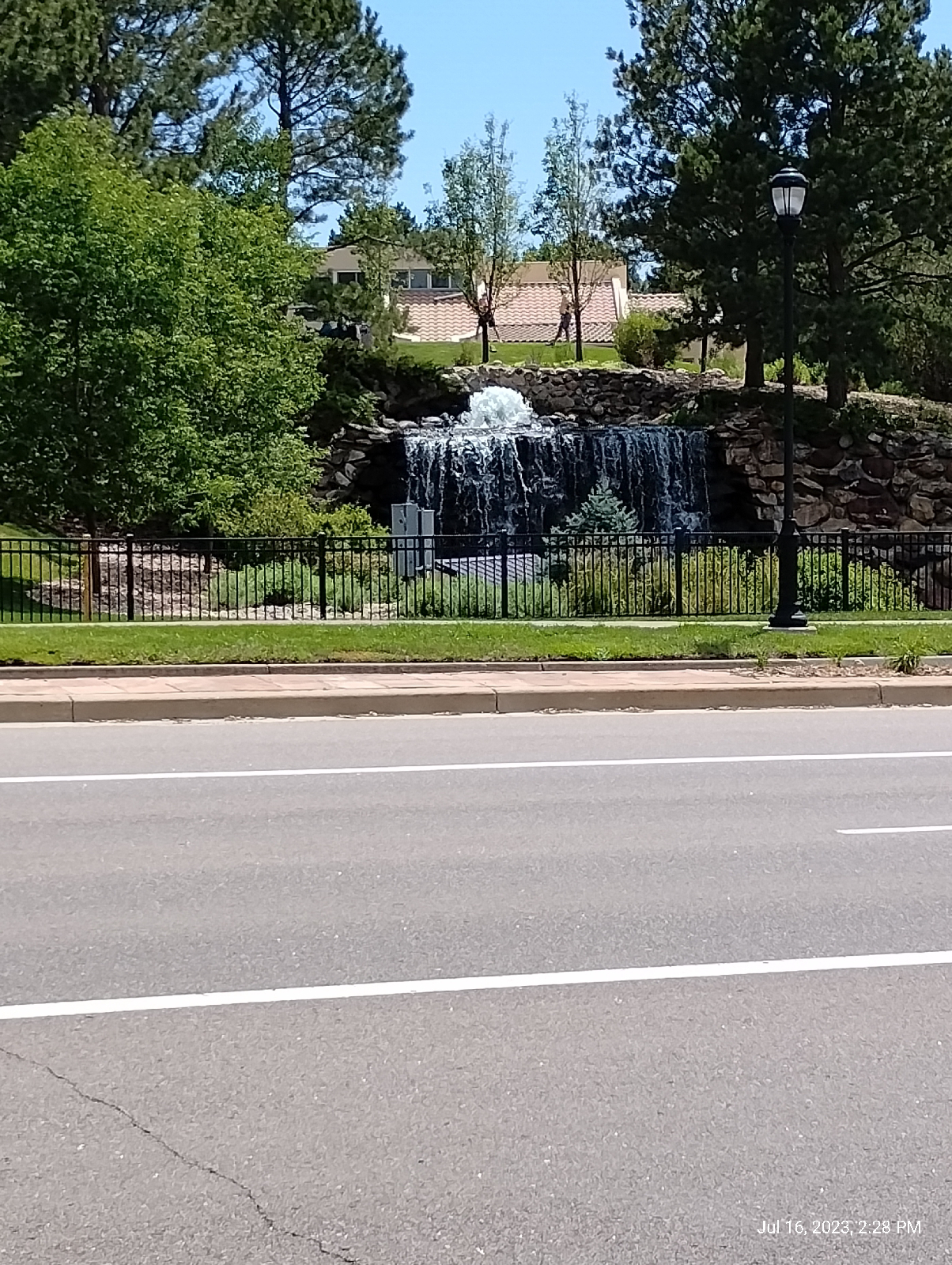
[Cascade on Little Dry Creek]

Little Dry Creek is lined in several places with rock and there are several of these rock cascades along its course. They look better than the natural clay that blankets the Denver area and the sound of water running through rock is nice, but the primary purpose is erosion control. The clay is tough (try using a shovel on it) but soft and erodes easily...rock less so. 

As water flows downhill, it expends  energy by digging into the creek bed. An obvious character of this neighborhood is it's gradient from east to west. The creek is burning off a lot of energy here. The rock cascades are placed in areas of greater slope so the creek can drop energy on granite instead of clay.

One day later…

[Little Dry Creek]

it's spring again!

This is Colorado in the fall. We're right where the North American jet stream whips around like a hooked earthworm and it draws down brutally cold air from Canada one day and warm Pacific air from the west the next.

Weather is known to be a chaotic process, impossible to predict past a certain horizon. In South Alabama, where I lived before moving to Colorado, meteorologists could do quite well a week or so in advance. They do well to make accurate forecasts a day in advance here. Alabama's secret is that they watch us. We're where their weather comes from.

[Ducks]

Of course, the ubiquitous ducks use all the waterways in this area. Lots of waterfowl do. 

We used to be on some major migration routes for birds moving between Canada and points south but, as climates have shifted to warmer temperatures, many of the birds have decided that Colorado is a pretty nice place to just stay year round.

[The Rockies from Arapahoe]

The east-west streets in this area, like Arapahoe and Dry Creek Road, provide some pretty impressive views of the mountains. The parking lots at Arapahoe Marketplace are at a considerable elevation over the South Platte River Valley and provide some particularly nice views of Mount Evans and the mountains around it.

Just the elevation between Quebec and Yosemite here is around 75 feet (that's my elevation gain when I'm packing groceries from the grocery store to home). At home, I'm 440 feet above the river according to the National Map on the United States Geological Survey website, https://viewer.nationalmap.gov/advanced-viewer

A walk around the northeast corner of the neighborhood provides a good grasp of it's topography.

[Uinta Street]

The view down Uinta Street makes it quite obvious that Walnut Hill is the steep side of the valley cut by Little Dry Creek. The broad contours are the result of millennia of rare floods. The steeper gouge that the creek flows through is the result of constant scouring through the soft, sticky clay.

The clay that covers the area is the residue of weathered volcanic ash. Although there isn't much volcanic activity in the area now, There most certainly has been in the distant past (not so distant in geological terms). The two Table Mountains in Golden, ancient volcanoes, make that abundantly clear. The uplift caused by the Pacific Plate slamming into the western edge of North America, the origin of the Rocky Mountains, was a dramatic event. What we see today, the cragginess, has a lot to do with erosion by runoff, wind, and glaciers moving through the area.

But Little Dry Creek has done an impressive amount of work over the years. The elevation profile of Walnut Hill Trail gives a good idea of the drop in elevation…141 feet from Yosemite east of Walnut Hill neighborhood to Quebec at the west border. The trail has grades of up to 16. Trail grades, like most slopes are measured as rise-over-run, so that would be a slope of 16 feet up for a foot along the trail.

This profile was recorded using the AllTrails app. Elevation measures using GPS can be as much as 47 feet off in this area but comparisons with other sources like Google Earth indicate better accuracy. This profile might be around 20 feet off. 

A south-to-north profile along Spruce Street gives an idea of the shape of the valley. 


The profile isn't a straight slope down to the creek, water on the Earth's surface doesn't flow straight and, consequently, over time, the course of a stream changes and the surfaces carved into the ground are complex. Also, notice on the map that my path wasn't straight. Spruce Street is interrupted as it runs through the Walnut Hill neighborhood.

Notice that the southern slope of the valley is a lot higher than the northern slope. Well, not really. The northern slope continues on the other side of Arapahoe Road.

When I returned home, this flicker was waiting for me in my backyard. 

[Flicker]

Flickers are related to woodpeckers and sapsuckers. We have an abundance of all these in Colorado. Thanks to my birdwatcher friend for identifying this one.

These explorations happened in the space of a week and I help out in the Christ Church Episcopal Library on Wednesdays, which gave me an interlude. I took a train back to the old neighborhood. That gave me the opportunity to look around Village Center. The Lightrail Station features a long suspended walkway over Interstate 25. I'll have to revisit that when I write a blog on bridges. This one combines a walkway suspended by cables suspended by an arch.


[Bridge at Arapahoe at Village Center Station.]

I also checked out Tower 1 at Village Center, the twenty-two story building that can be seen from all the neighboring areas. The person at the information desk was informative. He explained that the tower was an office building built in 1987. The entire top floor is occupied by a law firm, so there's no public Access, but the view from the ground is nice.


[Tower One, Greenwood Village Center]

This odd little conical Hill is just at the boundary of the Lightrail Station. It's surrounded by … stuff - not particularly scenic stuff - but it's a pretty little conical Hill with a spiral walkway to the top.


[Conical Hill]

Two of the three highest peaks in the Front Range of the Rocky Mountains, Mount Evans and Pike's Peak, are visible from this area. The highest, Mount Elbert, is also the highest in Colorado, but it's a little too far west to be seen from here.


[Pike's Peak from Walnut Hill neighborhood]

And here's Mount Evans.

[Mount Evans from Walnut Hill neighborhood]

We also have our share of raptors. This young hawk scrutinize me from his perch in the western part of Walnut Hill Park.

[Hawk]

I frequently stop in at the Mini Moo Tea Shop in the shops along Arapahoe. They let me take a picture of their "dog".

[Mini Moo's dog]

Dry Creek Road, at the southwest corner of Walnut Hill, has some spectacular views of the Front Range.

[Front Range]

The snow capped peak to the right is Mount Evans.

I extended my walk in the southwest corner of the neighborhood along Quebec at the western border of the next neighborhood - Willow Creek. It resembles Walnut Hill in that the main topography is a creek valley. 

[Willow Creek]

On my last excursion, I noticed that Walnut Hill Elementary School has added an "A" to their curriculum. "STEM" is now "STEAM". "STEM" stands for "science, technology, engineering, and mathematics". STEAM adds "arts". There is a move to change it to STREAM and add "Reading and wRiting". It looks like we're back to the three Rs.

Your neighborhood is an adventure. Explore it.