Showing posts with label weather. Show all posts

Saturday, April 18, 2026

Roswell: Highway 285 to Berrendo Road - The Land

 Roswell is situated in the northern region of the Chihuahuan desert. Roswell is on the Great Plains. Roswell is grasslands. Roswell isn't obviously karst but it's karst nevertheless  Roswell is flat but not perfectly so. Roswell is dry but Roswell is an oasis.


Roswell is at 33° 23' 39" N 104° 31' 22" W. Selma, Alabama, where I used to live is at coordinates  32° 24' 59", about one degree latitude difference. So why is the environment so different. Selma is forested..... Roswell is desert. We'll get to that later.

The city is at 3,615 feet altitude. People are surprised by that after seeing how flat it is around here 

The Pecos River flows 7 miles to the east of the city. The highlands that rise to Sierra Blanca begins about 40 miles to the west. The Rockies are about 70 miles to the west. In Denver, I had the requisite photo of the Rockies in my blogs. Here, it will be Sierra Blanco. 

The city has an area of 29.776 square miles (according to the United States Census Bureau). Chaves County, of which Roswell is the largest city, has 6,075 square miles. 

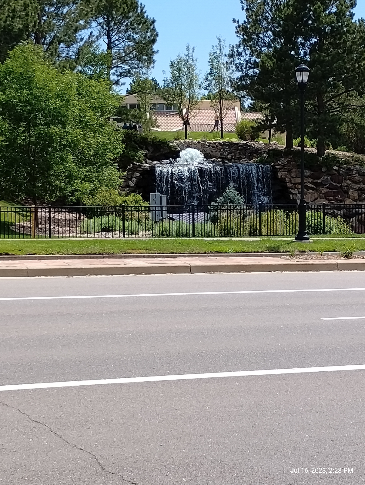
There are actually natural streams in Roswell. Some are dry now because the springs that fed them have been repurposed for industry and agriculture, but Spring River in South Roswell still flows (I think. I haven't made it that far yet.)


The land between Berrendo Road and Pine Lodge is primarily landscaped by Berrendo Creek and the Pecos River.


Pine Lodge from my house

It's flat around here. On my 1.7 mile walk into town, I get an elevation gain of 13 feet (according to measurements made by my AllTrails app.)

There is a blog discussing Berrendo Creek and I'll be posting a blog about Bitter Lakes Wildlife Refuge soon. That park is nestled beneath the Comanche Bluffs in the flood plains of the Pecos River  Berrendo Creek meets the Pecos River a little south of this section.

I say that the land is flat here but there is a little topography 


A draw on highway 285 North truck route north of my house.


Road cut on highway 285

The largest incline I'm aware of is the ravine that Berrendo Creek has cut through town, now dry, something between 20 and 30 feet deep.


Berrendo Creek 

Like the Denver area, the Chihuahuan desert was once an inland sea and many layers of sand, lime, and gypsum have been laid down to make up the rock under my feet. The ground outside looks like ceramic but is actually soft.


Desert soil

It is limestone, or at least dust blown in from limestone. That's evident when it's mixed with vinegar.


If you want to know if a substance contains a carbonate, just add acid. Vinegar is a weak acid but it will make calcite (calcium carbonate) fizz quite nicely, giving off carbon dioxide and leaving calcium acetate behind in solution. Dolomite (magnesium carbonate) may need a little warming to effervesce.

The main bedrocks in the area are limestone and shale but there have been a lot of diverse layers laid down over a long time. My primary source is the strategraphic column provided by the Rockd geology app. (Childs, O.E. (1985) Correlation of strategraphic units of North America, COSUNA.AAPG Bulletin 69:173-180).

The top layer is very recent Ogallala formation deposited by area streams. It's mostly sandstone and gravel. Beneath that is a later of volcanic material from 63 to 19 million years ago. We're just east of the Rio Grande Rift where North America tried to pull itself apart. There has been a lot of recent (geologically speaking) vulcanism in the area. That big mountain on the horizon, Sierra Blanca, is an extinct stratovolcano.

About a thousand meters down is the Grayberg and San Andreas formation limestones overlaid by about 300 meters of impermeable sandstone and shale. The limestone layer is interlaced with cracks that allow storage of a lot of groundwater. The shale cap keeps the water under pressure so that when it finds a channel to the surface it forms the many artesian springs in the area. It also feeds the Roswell water wells.

The Ogallala formation is also an aquifer but, here, it's recharge rate is slow and it can be emptied quickly. Most of Roswell's water comes from the deep aquifer. According to the city website, there are 20 deep wells that draw water up, chlorinates it, and distributes it out to the city. 

Roswell takes samples of treated wastewater daily, 60 samples a month, to test for bacterial contaminants and tests drinking water quarterly for chemical contaminants.

I bought a test kit (H2O OK Plus) to check our tap water. Most of the tests are on three test strips although the coliform test requires a tube of water plus reagent to sit a while.


The tests were easy and I was very happy with the results  


The water is hard but 247 parts per million is far below EPA requirements.

Hard water is water with high mineral content, usually calcium and magnesium carbonates. It happens when water is stored in a limestone or gypsum aquifer. Roswell's aquifer is mostly limestone but there is still plenty of gypsum and even some interesting evaporates.....minerals that form when landlocked lakes evaporate. They're touchy for mineral collectors because they tend to draw humidity out of the air and then dissolve in it.

Hard water might have some health benefits (except for kidney stones for people predisposed to it) but it can play havoc with pipes and laundry. Calcium carbonate tends to precipitate out in cakes. Also, the calcium ions will combine with the sodium stearate (soap) to firm an insoluble, slimy, scummy precipitate of calcium stearate. The best way to tell if the water from your tap is too hard is that you can't get soap to lather. We get scum but the soap will lather. And unlike some folks, I like the mouth feel of coffee creamer in hard water 

Roswell gets it's water from the deep aquifer but there are three major streams and a few intermittent tributaries that run through town. I explore Berrendo Creek in an earlier blog. Most of its length is usually dry but when it's wet, there's a flood.

I haven't seen the other two yet.....they are Spring River and Hondo Rio. All of these streams are tributaries of the Pacos River that flows 7 miles east of Main Street  I'll talk about the others when I get to explore them.


The Pacos River at Bitter Lakes 

Most of the natural water here is green. The green isn't pollution..... it's calcium. Here's another calcium loaded stream in Alabama 


Brushy Lake, Northwestern Alabama

The climate here is hot and dry with occasional cold (night and winter) and rare rain, which is sometimes devastatingly torrential.

My family moved down from Denver late in October of last year (2025). The days were warm and cool. It was a good time to move into the desert. The nights, as is normal year round, was cool. By December, the days were cooling down. The vegetation which plagued me on my trips to town for supplies was dying down to stubble. We had some cold days and one snow between January and March. I think it has rained three times since we moved, never hard. Wet ground evaporates quickly. The sunsets are always gorgeous given the capacity for the dry air to hold dust suspended and the frequent hard winds that whip it up. The skies are vast and blue.


The following is from the Wikipedia article about Roswell.

We have a cool, semi arid climate and four distinct seasons. Winter is cool and there is occasional snow that doesn't hang around long. Spring oscillates between warm and cool but there can be cold snaps.  There can be fierce winds. I clocked one gust last week at around 40 mph. I had to fight to walk against it. Summer is hot. Roswell experiences around 30 days out of the year above100° F. The North American monsoon season occurs during the summer and can bring torrential downpours and disastrous flash floods. The three streams that run through town can become raging rivers. The Berrendo ravine can fill up quickly.  Autumn brings relief. Things cool off although there can still be hot days, and snow is possible from October to March 

Since humidity is generally low and humidity causes changes to be more gradual, shade is considerably cooler than sun.

The record low: -24° F. (January 11, 1962, February 8, 1933)
The record high: 114°F. (June 27, 1994)

But the ground is that pretty cream color with glossy ground cover.....high albedo! This is a solar furnace. Hot anywhere else is HOT here.


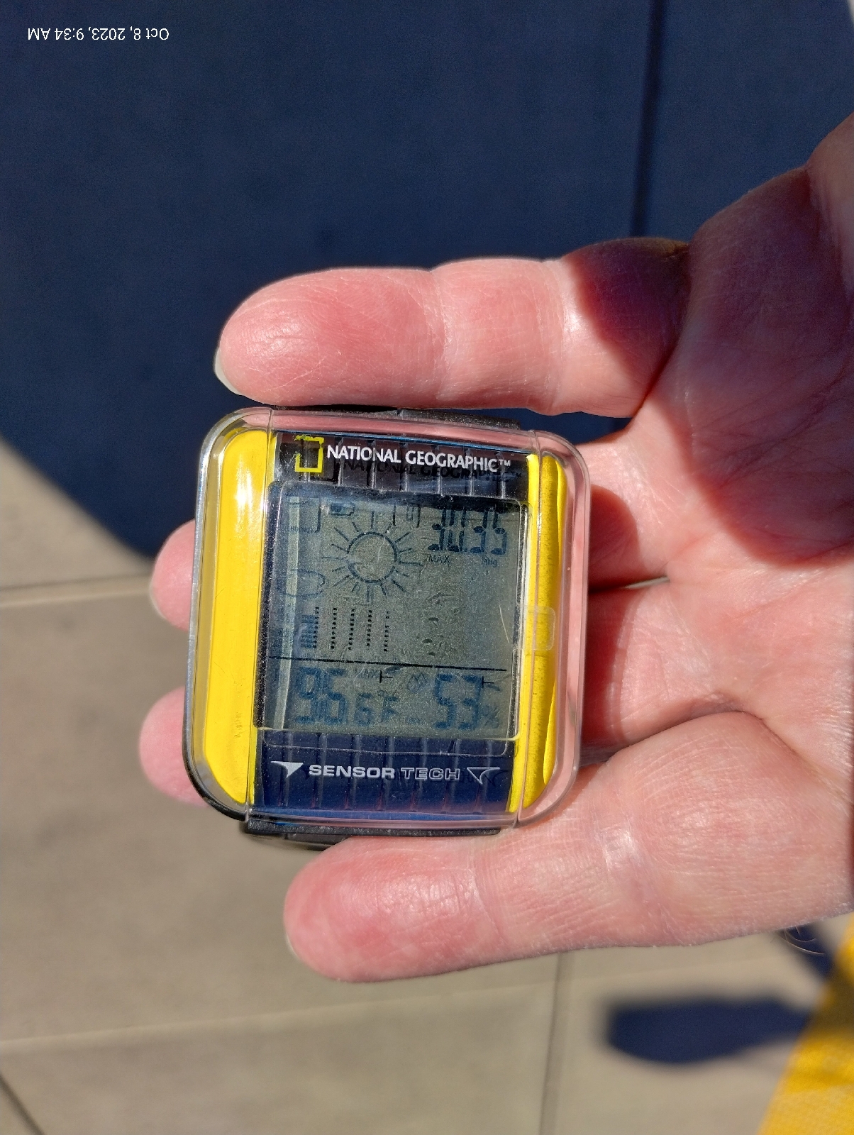
So, the weather report for today (I'm taking a day off!):

Air Quality Index is fair at 45
No precipitation expected
Wind at 5.9 miles per hour from the west (prevailing winds here are mild breezes from the mountains (west) and brutal winds from the south in the leading edges of fronts and from the north after the front passes - beware the tumbleweeds. They're cute but vicious!
Ultraviolet index is high ( as usual, at altitude, there isn't a lot of filtering from the atmosphere)
Humidity is 17%
Barometric pressure is 30.17 inches of mercury. (About 1.02 bar, practically sea level.)

Why is Roswell so different from Selma? 

The strip of land bordering the Rocky Mountains to the east used to be a vast, shallow inland sea. Over millions of years, plankton died, sank to the bottom, and left a thick layer (several thick layers, actually, interspersed with mud) of their calcium carbonate skeletons and shells. That turned into limestone....highly reflective limestone that baked and efficiently reflected heat back up into the air when the sea dried up 

But more importantly, New Mexico is in the rain shadow of the Rocky Mountains. As humid air flows in from the Pacific Ocean, it rises up over the Cascades and the Sierra Nevada mountains and the Rockies into cooler heights where most of the humidity precipitates out. This is the air that Montana, Wyoming, Colorado, New Mexico, and Mexico gets. The eastern United States gets humidity pumped in constantly from the Atlantic and the Gulf of Mexico. It's dry and there's nothing to buffer the heat 

So my journey to adapt to desert life continues. This Arctic wolf is going to have fun. It's not like I can lock myself in an air conditioned house and never come out. My heart condition requires real activity.

Well, adventure might be painful, but it's fun. No pain.....no gain!

:)

So.....land, air, and water. It's where you live. How is your world? What kind of rock is under your feet? Is there plentiful water or is it dry? Are there caves near you? That's a part of karst geology. Do you have seasons or is it summer one day and.....suddenly winter! Have you tested the water from your tap? Water testing kits are easy to come by, usually from local hardware or home supply stores.


Sunday, October 15, 2023

Anatomy of a Mountain Range 1: Morrison


October 8 (it's been awhile but I completed this blog and then it vanished so I had to do it over) I started out as usual for Arapahoe Station. This photo at the junction of Arapahoe and Yosemite shows a clear day that promises good weather for a long, strenuous hike. I wasn't disappointed. The actual hike began two trains, a bus, and a Lyft taxi later.

56 degrees and 53% humidity. Woof! 

I took some measurements to compare with measurements at the start of the hike while I waited for the second train at Broadway Station. The barometric pressure was up and stable. I had a sweater on but it wouldn't stay on for long. 53 degrees is pretty warm for me, given this untempered Colorado sun.

Mount Morrison is front and center. It's the first actual Rocky Mountain near Denver. The rest, Green Mountain, the two Table Mountains, Mount Carbon, the Dakota hogback, Red Rocks, are all foothills.

Here's a closer view from the Wadsworth Park and Ride where I waited for the taxi. Red Rocks Amphitheatre is right there.
The big rock on the right is Creation Rock and the one on the left is Shiprock.....uh, or is it the other way. Honestly, the names have swapped so many times I can't keep up with them. But they are red. The reason they don't look red is that phone cameras add blue to pictures to make them more presentable. Like most red in nature (some exceptions are cinnabar, rubies colored with chromium, cuprite, and red flowers and leaves), Red Rocks are red because of iron, specifically hematite (aka rust).
I usually enter Morrison on the Bear Creek Trail on the south side of Morrison Road, but the taxi let me out at the Phillips 66 on the north side and I noticed that there was a footpath that skirts the base of the road cut, so I took that. It was a good choice for a closeup view of the Dakota hogback.

It's called the Dakota hogback because it's capped with erosion resistant Dakota sandstone. Actually, it's layered with other stuff like this volcanic ash from an ancient volcano far to the south that blew it's top about 100 million years ago. Take note because you'll see it again. The hogback is a star of this hike.

During the Cretaceous period, around 100 to 95 million years ago, an interior seaway opened that split North America in two. Rise of sea level and erosion of gradients to the east and west slowed river flows, for instance, from hills to the west in what is now, Nevada and Utah, causing them to dump fine sediment along their routes and into the inland sea. This compacted to form the sandstones, clays, mudstones, and shales of the Dakota formation. 

These rocks are widespread in North America, from Canada to Mexico and from Iowa to Nevada. These slow moving streams and swampy lowlands were host to a lot of life, big and small, and when that life died, provided an excellent environment for the production of fossils. Dakota rock is a rich source of many of the dinosaur skeletons that grace natural history museums of the United States today.

Climbers were out on the anticline this day. An anticline is a mass of rock that has been folded upward. The Dakota hogback ("hogback" because it reminded someone of the ridge along the back of a wild pig) is the result of the same mountain building event that raised the Rocky Mountains. A little further east, the rocks folded downward forming a big bowl, a syncline, the Denver Basin, that filled in with the sediments from the eroding Rockies. I remember that a syncline is a downward fold because "sync" sounds like "sink" and an anticline is...well, the opposite.

This road cut through the hogback is also the mouth of Bear Creek Canyon which opens up the Rockies back to Evergreen and the area around the base of Mount Blue Sky, third highest mountain in the Front Range. You can see it as the gray mountain in the distance in the photos at the top of this blog. It's gray because the peak is above the timber line, over 14,000 feet. No trees grow in the thin air and top soil up there.

The trail that parallels Morrison Road through the road cut let me out at the eastern border of the busy (always busy) tourist town of "historic Morrison", home of interesting shops and good places to eat. It was too early for my favorite burger place in Morrison, the Mill Street Inn, so I went across the street to The Cow for a milkshake. As I get older, I rarely eat real meals on hikes anymore. I focus on drinks to prevent dehydration. That's a major concern in dry Colorado.
Maple Street, across the road, heads up to Red Rocks Elementary School. I wanted to check out the intersection. Morrison Road passes through town through the mouth of Bear Creek Canyon and turns south there between the hogback and Mount Falcon. (The small but excellent Morrison Natural History Museum, home of what's left of dinosaurs, is down there.) Bear Creek Road branches off west toward Evergreen.

Several formations come together here.

The Dakota formation continues out under Morrison which is built on much younger unconsolidated materials of the Post-Piney Creek and Piney Creek alluviums, material that has been laid down by modern streams, mostly Bear Creek and Mount Vernon Creek, which parallels the hogback to the west.

Just before the intersection, the Lykins formation shows up as brown, iron rich sedimentary rock.

I guess this is a good place to introduce the rules of sedimentary succession. They're pretty intuitive and are important for dating rock....before radioactive dating it, and the identification of certain characteristic fossils, were about all that geologists had to build the geologic time scale.

The Law of Superposition: Younger formations are on top. That makes sense. They were the last sediments to be laid down.

The Law of Original Horizontality: Sediments are initially deposited horizontally. Gravity dictates that. That big anticline in the pictures above was originally flat as a pancake.

The Law of Crosscutting Relationships: If a layer cuts diagonally across rock, the crosscut is more recent. The younger rock cut through rock that was already there.

The Law of Lateral Continuity: If you see a layer in one part of a formation, don't be too surprised if you see it again miles, many miles, down the road in the same formation. It'll be the same layer, the same age.

These principles were first recorded by the 17th century Danish geologist Nicolas Steno, so they're also called Steno's Laws.

The Lykins formation lies atop most of the others in the area (except the debris piled up by the present day creeks) so it's very young by geological standards. About 250 million years old, the Lykins formation shows as a thin band of clay, mudstone, and limestone just west of the Dakota hogback. In places, it's banded, displaying it's only fossils, the sticky algae that were about the only thing that could grow in the muddy swamps of the Permian and Triassic boundary of the region. The Lykins limestone is responsible for many of the few caves in Colorado, like the ones around Manitou Springs near Colorado Springs.

Just west of the Lykins rocks the stone suddenly shifts to the red arkose sandstones of the Fountain Formation that made Red Rocks famous. It also makes up the spectacular scenery of Boulder's Flatirons and the pinnacles of it's Red Rocks Park, the standing stones of Roxborough State Park, Colorado Spring's Garden of the Gods, and even the big rocks scattered around Woodland Park's Red Rocks Campground, west of Pike's Peak. The Maroon Bells on the western slope of the Rockies are also of the Fountain formation.

You see it here as the red stone overlaying harder blonde sandstone. The Fountain formation is around 300 million years old, composed of material washed out of the Ancestral Rockies. It pretty much blanked the area where the older mountains were and when the current Rocky Mountains were uplifted by tectonic forces of the Pacific plate crashing into the North American plate far to the west, the shell of hard sandstone was cracked and pushed skyward, often standing on end.

The blonde sandstone is of the Lyons formation. You can see it in the walls of the buildings of the University of Denver campus in Boulder and the buildings and restraining walls around the Denver Tech Center. The hard sandstone that naturally breaks into sheets is a beautiful, durables, and popular building stone. It's about 280 million years old and....

Wait a minute! Aren't younger stones supposed to lay on top of older stones? 

Well, yeah, generally, but sometimes things get flipped over and then you have to look for an explanation. This one's easy. Like I said, when the Colorado Plateau was uplifted to form the Rockies, it stood the Fountain formation on end, then the inexorable erosion continued working on the new Rockies, actually burying them in their own debris. This stuff formed the Lyons sandstone. Notice the slope of the blonde sandstone. It keeps rising upward until it is above the Fountain formation.

This sharp boundary between very different stones signal a fault. It's not always easy to see faults because they're usually covered by loose soil and alluvium but here it's clear.

Below the Fountain and Lyons formations is a big (big!) surprise. I'll show it to you in the next blog (wait for it!).


Monday, July 17, 2023

Lincoln Station to County Line Station


Blue skies. 91 degrees Fahrenheit on my weather meter. Those high, icy, citrus clouds mean that there's moist air moving in up there but down here, it's just hot and humid (33% humidity) and promises to get hotter. Atmospheric pressure is up and down and I don't expect any storms to break the pattern.

But, visually, the day is beautiful and I can focus on that.

These early E/H Line hikes explore Willow Creek. It is a nicely typical stream to explore.

 Notice that the Bluffs seem to curve around something...like a chunk has been gouged out in the middle. That's because a chunk has, indeed, been gouged out in the middle. Willow Creek did most of that.

Remember that most of these streams, in the past, were much larger. Willow Creek was, perhaps, not a huge stream. The pictures you'll see show a fairly narrow valley, much smaller than, for instance, Little Dry Creek Valley, despite the fact that it runs a longer course.

Typically, a stream begins it's journey at a steep gradient that gradually gets shallower the further it runs. The amount of water it carries also tends to increase and it's power to erode downward into the earth decreases, although it's sluggish meanders broaden it's valley as it continues it's course.

Willow Creek isn't long enough to get out of it's steep, wild section before it joins with Little Dry Creek. There, it takes the other streams name and becomes Little Dry Creek as it runs down to the South Platte River in Englewood.

Of the two creeks, Willow is more variable and more likely to flood, partially because the aquifers that feed it are more productive. Most of their volumes are contributed by runoff and Willow has a longer run to pick up storm water.

The area around Lincoln Station is affluent and much landscaped, but landscaping isn't just about artistry as this sign explains. This area collects storm water and provides a porous surface which also acts as a filter to trap contaminants.

As usual, Lone Tree, a suburb of Denver, being a desert town, likes it's water features. If you want to see a waterfall in the Metro area, water features are your only options. This one is at the Lone Tree Golf Club.
This is a golf course so the landscape has been modified, but it does give an idea of how narrow and shallow the valley excavated by Willow Creek is.

On one hand, golf courses require a lot of water to maintain, pamper invasive lawn grasses, and sink a lot of agricultural chemicals into the ground, but they do manage the water they use and water fowl such as these egrets and ducks, like it.
Here is another shot of the valley back toward the headwaters.

After Lone Tree Golf Club, the creek flows through Sweetwater Park and the Park Meadows shopping district. Here it finds less managed, and softer land to cut into. Also, it has picked up water from Cook's  Creek and other sources. There are some interesting banks cut into muddy sandstones and sandy mudstones of the Dawson and Arapahoe formations.
I was pleased to see the tunnel under C470, the main bypass around Denver. The air in it is about 20 degrees cooler than the air outside.
There are some interesting stalactites hanging from a crack in the ceiling (Remember. If it's from the Ceiling, it's a stalaCtite. If it's from the Ground, it's a stalaGmite.) 

I suspect that these "cave formations" are made from gypsum redeposited from water percolating through  the sheetrock of the walls.

I really have to watch my hydration in this weather and, as I neared County Line Station, I really needed to cool off and get something to drink so I stopped at Tropical Smoothie Cafe for a large Watermelon Mojo Smoothie and a rest in the shade. Here's a view of the Rockies (and the top of my drink cup).

I took my time and felt much better when I walked the last short stretch to the station.

County Line Station is at the edge of the huge Park Meadows shopping area. The light rail and I-25 is on the other side of that wall.
In addition to a packed, sprawling parking lot, the station has some nice views of the surrounding countryside.

This hike brings me to very familiar territory. Little Dry Creek is the only stream in my neighborhood large enough to have a name but the southern ridge of Little Dry Creek valley is the northern ridge of Willow Creek. The next neighborhood to the South is Willow Creek covenant community and I will explore that on the next hike.


Thursday, August 19, 2021

When you can't see the stars...

Astronomy is a sometime thing (apologies to George Gershwin). Light pollution, haze, clouds, so many things can sabotage a night of stargazing, so what do you do when you want to see a star but can't.

Well, study the thing that blocks your view. I've been impressed with how well phone cameras can perform after the sun goes down. For instance, sunset doesn't necessarily end when the sun goes down. The sun may have set on you but the clouds above you are still in line if sight of a low, red sun.

Here are some low clouds over Centennial, Colorado about half an hour after sunset. 

Recently, we've been having some very uncharacteristic thunderstorms in the area. It's difficult to impossible to capture a lightning strike in a photograph, but a video is a different thing entirely.


Fog, smog, clouds are all interesting in their own light and they show a different face at night than they do during daylight.

Saturday, July 25, 2020

Clouds

"I've looked at clouds from both sides now"
Joni Mitchell


Lenticular clouds in Centennial, Colorado.

People have looked for images in clouds for at least as long as humanity has been recording it's activities.

I lived most of my life in the Southeast United States leaving only for a construction job in Montana, four trips to or through Denver (and the states I passed through on the way), and two seasons on a laybarge in the Gulf of Mexico. But I've seen some weather.

Every area has its distinctive weather. The reason we could predict our weather with any certainty in Alabama was that it was coming from where I live now, Colorado, and we had plenty of time to see it coming.

As each area has its characteristic weather, each has its characteristic clouds.

The massive high-topped thunderheads with anvil shaped tops are rare here. We get a lot more hail; they get a lot more tornadoes. They also get hurricanes.

We get these weird lenticular clouds like the ones in the picture above.

As air flows across the Rockies and out over the plains, it can set off standing waves, like those that form when a person blows across the top of a soda bottle. At the bottom of the waves, the air is warm and can hold moisture as invisible vapor, but when the air is carried to the top of the waves, it cools off and releases the water as cloud droplets. A person from the east might think "rain coming," but these are actually stable weather clouds, like the big fluffy cumulus clouds of the Southern summer.

Those Southern cumulus clouds could build up into far from stable cumulonimbus clouds. I had one drop a tornado into a farmer's field next to where I was driving once. I didn't usually speed. I did that time. Clouds can cause you to get excited.

I was driving near Tuskegee, Alabama on I 75 and there was this huge thunderhead over me. The bottom was flat and it looked like I could reach up and touch it. It was electric blue. There was so much water in the cloud that it piped the color of the sky above it right down to the bottom. That's the kind of cloud that can drop a tornado down right on top of you without any warning.

The funny thing is that I saw so much storm activity before I became a storm watcher about five years before my retirement and never saw sign of another tornado, not even during the disastrous outbreak of 2011.

One of the weirdest cloud formations I have ever seen were the hole-punch clouds one summer in Selma. An even sheet of clouds had big circular holes in it, all the way up to clear blue. We didn't know what caused them back then. It turns out that planes flying through clouds can cause droplets to coalesce, like when you put a drop of detergent in a bowl of greasy water.

The most beautiful display of weather I have seen was a very darkly overcast afternoon on a laybarge. There was a clear band on the horizon where the sun was setting blood red. It cast a red glow over the bottom of the clouds and there was a brilliant triple rainbow.

I've been chased up Mount Carbon three times by thunderstorms. Walking east from Morrison on the Bear Creek Trail carries you through a broad, treeless area of Bear Creek Lakes Park. With no cover behind me and no cover and a lung busting switchback before me, I heard a rumble at my back and turned to see massive black clouds boiling up over Mount Falcon. There was green-ness in them, indicating hail, which I didn't want on me, so I walked fast.

All three times I reached the shelter at Mountain View before the storm hit.

What causes cloud colors. Well, I talked about sunrise and sunset clouds in the last blog. Why are clouds white and, of all colors, dark gray? Is water gray?

We talked about Rayleigh and Mei scattering last time. Mei scattering is caused by aerosols, particles that aren't molecules but they're still small enough to stay suspended in air. And remember that Mei scattering doesn't pick and choose specific wavelengths of light like Rayleigh scattering does, so it's not surprising when clouds are white, but gray?

A few years ago, I built a Joly Photometer. It's basically two chunks of paraffin separated by aluminum foil. Here it is.


If you put a standard light source on one side and a light source of unknown brightness on the other, then move the unknown source nearer or further away until both sides of the Photometer look the same, you can calculate from the difference in distances of the light sources from the photometer how bright the unknown source is.

But notice that the two halves, which are from the same slab of wax and, therefore, the same color, look different. The apparent color is from the white light illuminating the wax. The top slab is lit by more white light ..therefore, whiter.

Clouds are the same way. Less light makes its way down through the cloud so places with less light look less white and our eyes are rigged to emphasize contrasts so, next to the bright white of the tops of the cloud, the bottom sometimes looks positively black.

Notice that the gray parts of clouds are usually a cool gray until sunset. The blue of the sky also comes through misty clouds.

If you ever visit the Great Smoky Mountains, you will see that they, indeed, do look smokey. That area has always funneled aerosols in, hardwood tree pollen, smoke, and more recently, abundant industrial pollutants and they disperse white light efficiently. Add in the sky blue and there's smoky mountains.

Green clouds are a place where light has to pass through so much dispersion that all the blue is gone. Notice that it's a sorta dirty brown, meaning that light at the red end of the spectrum is there, too . Clouds with that much water and ice in them will often mean hail. I run from those! Mother Nature doesn't want me there.

Hail forms in clouds with strong updrafts. High up in cumulonimbus clouds, water freezes into tiny ice crystals until they are too heavy to remain suspended in the air and then they start to fall, but they get caught in the updraft and are blown back up. They pick up more moisture and freeze another layer. These little balls of ice will ride winds up and down until they're no longer little balls of ice. When they finally fall to the ground, they can be destructively big balls of ice!

Cloud watching is a great pastime. You can get a good idea of what to expect of the weather in your area and, occasionally, you'll see something rare and spectacular!


Wednesday, July 1, 2020

Interlude

From the instant of its creation, the universe has been in the process of running down. It's called "entropy". To quote African writer Achinua Achebe and Irish poet William Butler Yeats, "Things fall apart." Except for some miracle - a Big Crunch or the Creator's decision that it's time to wipe the old slate clean and create a new, the inexorable March to uniformity will lead, in a few billion years, to a vast ocean of hydrogen, atoms so far separated that there will be no opportunity for them to crash together to form anything more complex.

But there is turbulence in time. Diversity feeds on itself. As long as things actively fall apart, they also fall together. There are swirls in entropy that pushes it, through sheer momentum against itself. One quality of living things is that they transform. They create order out of disorder. The inert dust and muck around us fall together, against all probability, to form...us.

Life isn't the only builder. There's also chaos. Nature decrees that matter attracts matter and, when enough gas and dust is pulled together, the crushing results begin compacting hydrogen into helium and then larger atoms, under fantastic heat, until the energy is expended. The heaviest element that can be created in a star is iron, but the death throes of a star, the nova, is incredibly energetic, crushing even more atoms together to form brilliant spectacles in the sky, destroying everything in the cosmic neighborhood, and blowing out clouds of element rich dust to settle down on the universe.

The dust we see in a sun beam is mostly the detritus of life - dead microorganisms, and in our homes, skin cells sloughed off our own bodies and the tiny creatures that eat them. But a significant portion is micrometeorites, much of it, that fine dust blown out by dying stars. Over millions of years it has settled on Earth along with the usual products of erosion and, in the molten mix of tectonic plates, heavy elements concentrate in globs of magma to be extruded in cracks near (in geological terms) the surface where it can cool into rich veins of ore.

It might have happened in the crash of two such plates in the Earth's crust that buckled, what would be North America, thousands of feet upward to form the Colorado plateau. Or maybe before. That wasn't the first time the crust had been buckled around here. The Appalachians once rivaled the Himalayas in grandeur but, over time, they were worn down to the narrow band of mountains they are today. The Ozarks had their time.

But time has been working on the Wild West, too, eroding the smooth skyland of Colorado into deep ravines between towering mountains, dissolving ore veins into acidic, carbon dioxide rich lakes (the product of acid rains and dying organisms) where lead precipitated out into insoluble lead carbonate, cerussite, carrying other heavy elements with it, including silver. 

Nature values nothing. She just acts. But the new (in geological terms) animal invading the continent of North America brought a brain that valued much, especially that which is rare and that which glitters...and silver is both rare and glittery. Those that came from the east recognized the white sands below the highest mountain of the North American Rockies, Mount Elbert, to be composed of cerussite and understood that it often carries silver.

When that was confirmed, the new town of Leadville, Colorado, founded in 1860, began attracting miners and miners attracted other civilized creatures like the faro dealing Doc Holliday, fellow Georgian turned Coloradan (he's now buried in Glenwood Springs), and the unsinkable Molly Brown...

and myself. Yesterday, two friends and I, taking a break from stargazing and pendulum watching, traveled to this interesting little village below Mount Elbert to look at saloons and city halls preserved for posterity and tiny homes. And here are some pictures.


Mine dumps and mountains
The Old Church on Harrison Avenue and Mount Elbert.
Lake in the mountains

My personal transportation for several years has been the trains and buses around Denver but with Covid-19, I've avoided them since they require a mask and it's hard for me to get enough air through a mask.

I still walk to the shops in the area. There are always interesting things on the way.

One of my favorite wildflowers, the common milkweed, is blooming now.
Purple seems to be in vogue. This is Colorado and thistles are everywhere.

These rare gems are a variation of the Mallows that are everywhere. They're called "cowboy's delight" or "copper Mallows." It's strange to think of them so closely related to hollyhock, hibiscus, and marsh mallow (yes, marshmallows were originally a plant product, made by whipping up the thick, starchy solution from marsh mallow roots.)

We've been having moist air coming over the Rockies, giving us occasional rain storms to cool off our afternoons.
The public library has been closed for remodeling and now, with Covid 19, will it ever open? Stay tuned.

Much of our weather has a lot to do with the jet stream that shifts like an injured snake over us and the Rocky Mountains to the west. I've flown over the Rockies in a jet and from up there, they don't look quite so big and, after all, what's 14,000 foot mountains when the atmosphere is well over a million feet thick.

But when a tsunami is far out at sea, you can only measure a small change in the surface of the ocean. It's only when the depth changes that the sea turns into a great wall of water.

When air masses flow over the mountains and then out over the plains, they can set up vibrations. As the moist air moves upward, it cools off and water condenses out in the form of clouds. The air at the bottom of the waves is clear.  We get interesting rows or hatches of clouds. Sometimes, they're said to look like UFOs. Technically, they're called "lenticular clouds" for their resemblance to lenses.


Little Dry Creek is up now. It's not a mountain Creek, so it's not from snow melt. It's being fed by the afternoon showers and there seems to be a lag time between the rain and the rise in water level. I'll have to check that out sometime.

All walks are interesting. If you stay aware of your surroundings, there will be plenty to engage you.