Tuesday, February 5, 2019


--- The long and the short of it ---

I like long hikes and hikes under extreme conditions. They teach me things, too. I've learned a lot about how my body operates and especially how to handle stress. But this blog isn't about limits. When I talk about a steep trail or a thirty mile day hike, I'm not suggesting that people follow my example (though I'm sure there are people who have never done it that could and would enjoy it.)

You don't have to hike for miles to see new or spectacular things.

In my estimation, the best all around waterfall in Alabama is easy to get to. When you park at the High Falls trailhead between Talledega and Ashland, Alabama, you can hear the roar of the three waterfalls, stacked one on top of the other, and a short walk will bring you to this.


                                                             [High Falls, Alabama]

Some spectacular things are close by and you have to look close to see them. On my last walk to the library, I saw this on the parking lot across the street.


                                                                          [Ice]

This ice looks like a claw rake to me. What caused that?

A car had driven in the parking lot while snow was falling and it packed the snow down between the tire treads, then more snow fell on top of it. When the snow melted, the part that had been packed down was more resistant and remained. By the time I returned from the library, this delicate ice sculpture was gone.

So what?

Well, you can thank the same principle for the rock formations of the Fountain Formation - Red Rocks, Garden of the Gods, the red sculptures in Boulder's Eben G. Fine Park, and other red rock features along Colorado's Front Range. By some process or other, sand became packed down long ago and was overlaid by more sediment. When the blanket of softer sediment was worn away by wind, water, and weather, the red rock spires were left behind.


[red rocks]

Keep an eye out for what's down around your feet. You might spot some spectacular thing down there.


Tuesday, January 22, 2019


--- Spanish ---

I have a couple of useful tools outside my Spanish study materials.

Who needs a Spanish to English dictionary when you can type "translate spanish to english" into the Google search bar to come up with a Spanish to English translator. I hope it doesn't become  a crutch. I also hope that, if I see the words enough times, they will stick.

Google provides many instant helps in their Internet search utilities. For instance, you can type "convert inches to cm" and you have an Imperial length to metric length converter. "google help" or the following address will give you a lot of information about what you can do with Google.

https://support.google.com

Also, in Denver, most public notifications, including many labels on groceries, clothes, and such, are in Spanish. I already know many Spanish words from just shopping and riding on the RTD.

Tags: Spanish, Google tools

Thursday, January 17, 2019


--- The Capitol ---

Denver has a lot to offer the adventurer - a lot of culture, history, technology, art, food, sports, entertainment...but the first fact about Denver is the capitol. For everyone outside of Denver, Denver is the Capitol of Colorado.

Buses stop all around the Capitol building, so it's not hard for the pedestrian to get there. Coyote and I took the D Line to the 16th street mall and walked south - it's not a long walk and it's easy to enjoy the street life at any time of the day. Not long ago, I attended a town meeting at Civic Center Park and ended up walking up 16th Street Mall after dark. I think, if I wanted to recommend a city to a friend for night life, it would be Denver.

Civic Center Station, the big downtown bus terminal, is at the south end of 16th Street Mall and the capitol is just across Colfax from that - you can't miss it.


                                                                      [The Capitol]

The visually most outstanding characteristics of the building are the sheer size and the gold dome. The original dome was copper, but Denverites rejected the use of copper and pushed for the more natural gold. Only 4 pounds of the stuff is needed to cover the entire 2842 foot square surface. Although the gold is from Colorado, it is sent to Italy to hammer into the thin foil, thinner than a human hair, used to cover the Capitol dome.

Ten other states have gold domes on their Capitols and two others have gold cupolas. Gold is popular. Many of the states just buy their gold. The Denver dome is gilded with gold from Colorado mines.

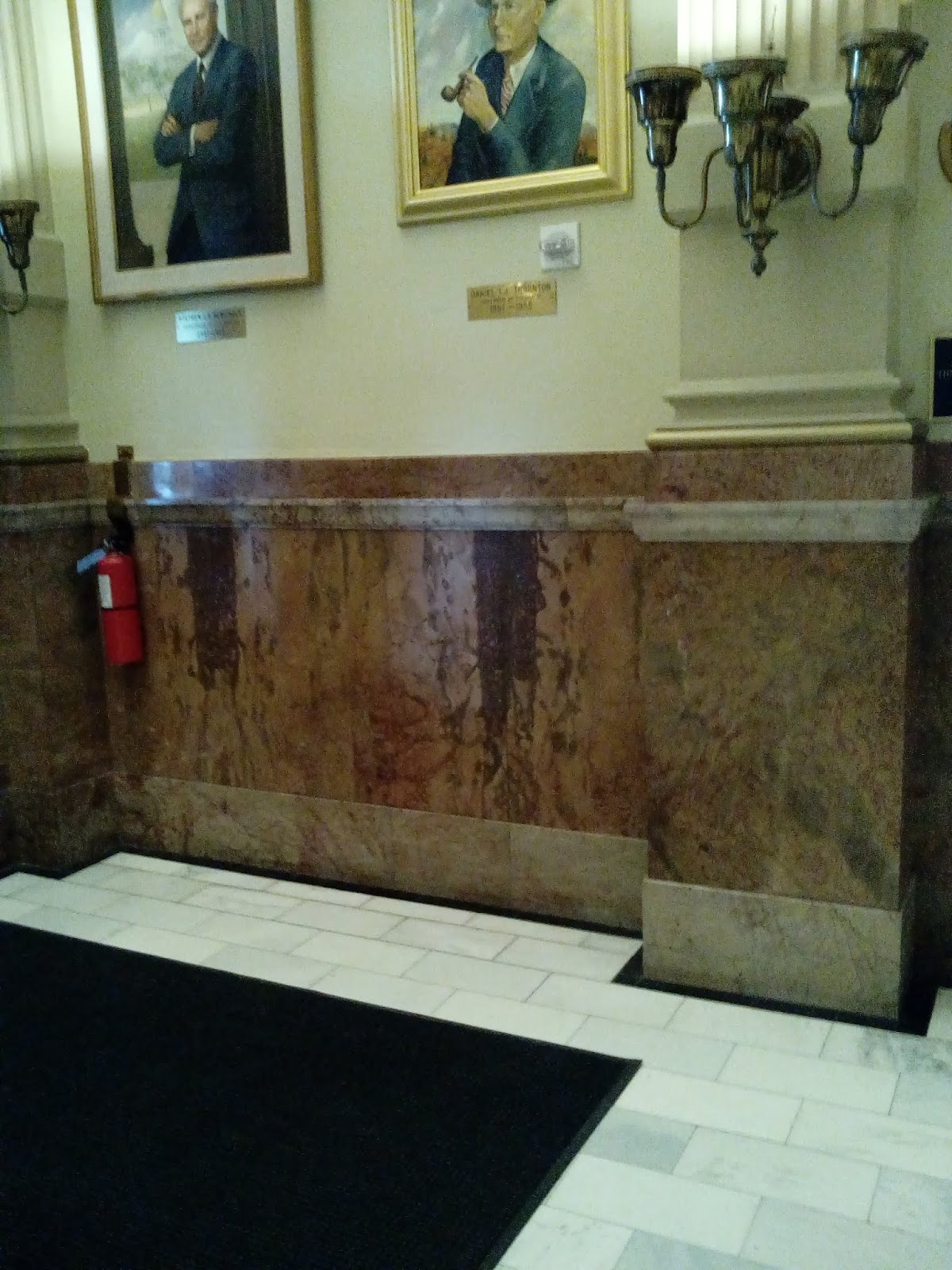
In fact, most of the materials used to construct the Capitol building are from Colorado. The Yule Marble used in the floors and stairs, from Marble, Colorado, is also the marble of the Lincoln Memorial and Tomb of the Unknown Soldier in Washington, D.C. The rose onyx used for the walls is from near Beulah, Colorado, is unique in the world, and is almost all in the Capitol - so don't go to Beulah to see rose onyx - it's all here.

                                                                [Rose onyx walls]

                                                                         [Grand stair case]

Only the brass (there a four or five people employed in the Capitol just to polish the brass fixtures) and white oak are from other states. The brass is from Cincinnati, Ohio and Louisville, Kentucky, and the oak is from the Ozarks in Arkansas and Missouri.

I couldn't take enough pictures nor could I fit them into a blog. The building is packed with art objects

                                               [Murals on the first floor rotunda walls]

The tour took us up the rotunda (stairs, lots of stairs) to some of the room galleries and balconies and behind the scenes to see the inside workings. The copper dome is still there. Most high peaked domes like the one on the Colorado and U.S. Capitols are more ornamental than stable and overlay an inner spherical dome.

                                                              [The rotunda]

The United States says "government for the people, by the people, and of the people," Colorado enacts it. There is every opportunity for the citizen to be active in Colorado government. When Colorado says, "This is your Capitol," they back it up.

Even the security staff at the Capitol building were friendly, helpful, and professional. The tour guide reminded us several times that, when the tour was finished, we were free to look around all over the building.

The Capitol building houses the headquarters of two of the three branches of Colorado government - the executive and legislative branches. The offices of the Governor, Lieutenant Governor, and Treasurer are on the first floor, and the House of Representative and Senate chambers are on the second floor. There are galleries on the third floor where visitors are welcome to observe legislative proceedings. Videos of proceedings are archived and are available on the Internet at https://www.coloradochannel.net .

The Colorado Supreme Court is housed across the street in the Ralph L. Carr Colorado Judicial Center Building across the street. I haven't made it there yet, but it's on my list.

The House chambers is painted blue and the Senate chambers is red like the Parliamentary chambers in Britain.

                                                                  [Senate chambers]

                                                               [House chambers]

Although much of the Capitol is as it was completed in 1901, as you can see, there have been  modernizations like the electronic call board on the wall of the House.

Stairs - many, many stairs. The Capitol tour takes you all the way up to the outside balcony of the dome, where the views are spectacular. At the west end of Civic Center Park (see the mountains?) is the City and County Government Building.

                                                               [The view west]

Just across the street to the southwest is the Ralph L. Carr building of which I spoke above. It has roof greenery.

                                                             [Ralph L. Carr Building]

Down the street is the Cathedral Basilica of the Immaculate Conception with it's towering Gothic architecture.

                                         [Cathedral Basilica of the Immaculate Conception]

After the tour, I shot some street views.

                                                                         [Colfax]

The sun was in a bad place so many of the pictures were blurred or glarey. I did manage to get the statue around back of the Native American examining a buffalo carcass. It is called "The Closing Era" and it was created by Preston Powers for the 1893 Colombian Exposition in Chicago. The name is, perhaps, a little short sited as Native Americans are reclaiming much of their "lost" cultures and heritage. Maybe the "era" was just closed for some housekeeping.

                                                              [The Closing Era]
Well, hopefully, if you are a Coloradan, you will take this tour. I've included blogs about Civic Center Park in the past and I'm sure there'll be more to come. The government buildings are scattered for several blocks around Denver and there are many statues and other works of art and history - I can't even begin to cover them all.

I've visited the seats of government in Washington, D.C.; Atlanta, Georgia; and Montgomery, Alabama and have seen many of the other Capitols from some distance. They're all spectacular. Most of them provide tours and you should also check to see how you can sit in on legislative hearings.

What they do in these government buildings affects your life deeply.


Sunday, January 13, 2019


--- Terminus: Union Station ---

Gold drew people to Colorado, but the promise of gold in the area that is now Denver proved to be illusory, so Denver restructured as a supply hub and thrived. Early settlements lay south of present Denver along the South Platte River and it's tributaries - Petersburg, Montana City, Auraria. Denver City grew across Cherry Creek from Auraria and when a bridge was built across Cherry Creek, the two settlements merged to become Denver.

The Union Station area was the location of early Denver.

On 1/8/19, I took the RTD E Line from University Station to it's terminus at Union Station, the central hub of the Regional Transportation District in Denver. At this point, 17th street is a mall with the light rail station at one end and the old Union Station building at the other.

                                                                 [17th Street mall]

                                                                 [Light rail station]

The mall includes the underground buss terminal and the Amtrak station, which will soon be the terminus for the light rail G Line out to Wheatridge.

The Amtrak station has light canopies that are sturdy because of their curvature. You can see the effect for yourself by holding a sheet of paper by one hand and trying hold something like a pencil or marble on it. The paper, of course, just collapses. Give it a slight valley and it will hold up a surprising amount of weight.

                                                              [Train station canopy]

The old station, built in 1881, burned in 1894, but was rebuilt in 1914. The whole complex was completed in 2012. The station house, reminiscent of many large city central stations with it's high arched windows, now houses the 112 room Crawford Hotel, several restaurants and shops, and a large train hall.


                                                                   [Union Station]

They were taking down the tall Christmas trees while I wandered around.

I once took the Flatirons Flier bus to Boulder. It leaves out from the Union Station mall. I wandered around the LoDo (Lower Downtown Denver) area for sometime before asking where the buses were.

They were underground. There are two pavilions at street level that house stairs and elevators to the underground bus terminal.

The ticket sellers are located in the underground bus terminal and I had some expired ticket books I needed to exchange. This time, I knew where I was going.

                                                                      [Bus terminal]

Merging back out into the sunlight at Chestnut Place, I was back at the light rail station and, looking west, saw the Millennium Bridge. I've seen a lot of reviews of the Millennium Bridge that remarked, "What's so special?"

Well, that's easy. It was the first of it's kind. It was one of three bridges begun in 1999 to connect the Highland community with LoDo. Before then, pedestrians would have to cross an interstate highway, a river, and a train yard to get to downtown Denver.

The Millennium Bridge crosses the train yard. It had to fit between some high bridges and the design was to provide a relatively small incline from street level, so an innovative cable-stayed design was used with a single 61 meter steel mast (the whole thing looks a lot like a pontoon boat with a single sail mast) to support the cables that support the walking deck. It is only 8 meters above street level, and it spans 40 meters (130 feet for you Imperial measurists) with a clearance of 61 meters (200 feet).

The Wikipedia has an informative article on the bridge here: https://en.wikipedia.org/wiki/Denver_Millennium_Bridge


                                                            [The Millennium Bridge]

It's also famous for having been in a movie (The Frame) and engineering documentaries - notably Stephen Ressler's Teaching Company presentation - Understanding the World's Greatest Structures.

I was a little unsure about how to proceed from the Millennium Bridge to see the other two bridges but I shouldn't have been. From the deck of the Millennium Bridge, the other two were in sight just to the north.

                                             [Commons Park from the Millennium Bridge]

Just north of Union Station is a strip of greenway along the South Platte River - Confluence and Commons Parks. If I had continued my hike north of Alameda on the Platte River Trail instead of moving east into Denver on my station-to-station hikes, I would have ended up here. Historically, this was a popular meeting place for Native Americans until gold was found here in 1858. Gold and water was the reason Denver was built here to start with.


                                                        [Speer Boulevard Bridge]

Looking west along Commons park (see the mountains?), I saw the Speer Boulevard  Bridge over the South Platte River. This is a classic steel arch cable suspension bridge. Cable risers hang the road bed from the arch. Just this side of Speer Boulevard is a more modern looking single span bridge that carries 15th Street and pedestrian traffic across the South Platte.


                                                               [Platte River Bridge]

The second of the  Highland access bridges is a light sidewalk held up by cables from two thin towers anchored midway the span. This bridge carries pedestrian traffic across the South Platte.

                                                                     [Platte River]

The 15th Street bridge separates Commons Park from Convergence Park, where Cherry Creek joins the South Platte. Here, the South Platte takes a turn to the east where it will join the Platte River far down stream in Nebraska near Ogallala. Cherry Creek, one of the larger tributaries in the Denver area, arises on the high plateau south of Denver and flows through Castlewood Canyon before becoming an urban stream.


                                                                     [Highland Bridge]

The Highland Bridge crosses Interstate 25. It is one of the three cable stay bridges and is the latest, having been completed December 16, 2006. The 325 foot long walkway is suspended under the sweeping arch constructed of steel pipe.

                                                            [Shoe hanging on the arch]

I thought this was a Southern thing. Down there you can see shoes hanging on power lines.


                                                                     [Confluence Park]

Cherry Creek isn't terribly spectacular, but the Platte River and most of it's main tributaries can become impressive when the weather is right - during the infrequent rain storms or when the snow pack melts from the mountains.

19th Street crosses the Platte River at the eastern end of Commons Park over an ornate steel trestle bridge.


                                                                [19th Street Bridge]

                                                                      [19th Street]

Following 19th Street back into town (I wanted to see Sakura Square and it is on 19th Street) is not as simple as it sounds. You have to get back across the train yard. Fortunately, there is a pedestrian bridge at the eastern end of Union Station that will do the trick.

                                                [Amtrak station from pedestrian bridge]


                                                                   [Sakura Square]

Sakura Square is a city block at 19th and Lamar Streets with a two story building with shops. The Japan American Society of Colorado has an office there on the second floor that (apparently) provides exhibits, but they were closed.

There is a small Japanese garden that commemorates three key figures in the Japanese American community.


                                                              [Yoshitaka Tamai]

Yoshitaka Tamai was a Buddhist priest who, born in 1900, moved to Denver in 1930 to establish the Buddhist temple at 20th and Lawrence Streets. The apartment complex at Sakura Square, Tamai Tower was dedicated to his memory in 1977, and the statue in the garden was placed on Sakura Square in 1996.

The engravings on the other statues, in white stone, didn't turn out well in the photographs, so you'll just have to visit Sakura Square to read them.

                                                                [Minoru Yasui]

Minoru Yasui (1916-1986) was a Japanese American lawyer and activist who was born in Hood River, Oregon. After internment in an American concentration camp during most of World War II, he moved to Denver in 1944. He received the Presidential Medal of Freedom posthumously in 2015.

The Wikipedia has a good article on the life of Minoru Yasui here:

https://en.wikipedia.org/wiki/Minoru_Yasui

                                                                    [Ralph Carr]

Colorado governor from 1939 to 1943, Ralph Lawrence Carr (1887-1950) supported the Japanese American cause during their internment in the concentration camps of World War II and afterward, the establishment of the Japanese American community in Colorado. He was the only elected official in the United States to publicly apologize for the treatment of American citizens of Japanese ancestry and that, arguably, cost him a U.S. Senate position.

I plan to visit the Ralph L. Carr Colorado Judicial Center in a few days and I will report on my trip afterward.

After eating at Sakura Square, I headed down Lamar Street to 15th Street and back to the light rail station at Union Station. From University Station, I walked to La Belle Rosette's for a signature espresso, and then to home. (jiggledy jig)

Bridges can be fascinating if you know how they work. There may be a famous one close to you. Take some time to really look at the bridges around you and see if you can figure out how they support their load.

If you want an in depth analysis of any of the interesting structures in Denver, Steven Ressler provides it in Understanding the World's Greatest Structures. Actually, I would recommend anything by him. He's knowledgeable, has a knack for getting difficult concepts across, is playful, and loves a good demonstration.