Showing posts with label Arvada. Show all posts

Saturday, April 1, 2023

Arvada Ridge Station to Olde Town Arvada Station: A walk through the 'hoods

ducks are pairing up now...

and showing off. The fountain at Arapahoe at Village Center was host to these two when I went through on the way to the G Line. It's March and we could still have snow. Some of our deepest accumulations since I've been in the Denver area have been in April. But any break in the cold brings all the birds out .

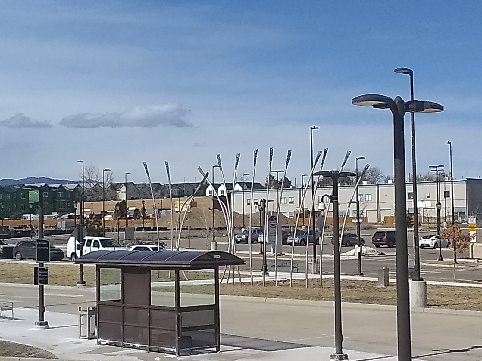
The art installation at Arvada Ridge station by Norman Lee and Shane Allbritton is called "Chromatic Harvest". It emphasizes the historical importance of agriculture to the area. Like the lenticular "animation" once popular on cereal boxes and trading cards (made possible by a special illustration overlain by a striated lens coating) this image shifts between two scenes as one walks by.

Wheat Ridge, of course, was named for the wheat once grown there (and the northern ridge of Clear Creek Valley where it is situated), and Arvada was once known as the "Celery Capital of the World". There's very little of that to see on the G Line. The art is there, though, on the parking level of the Arvada Ridge station. You can't see it from the platform.

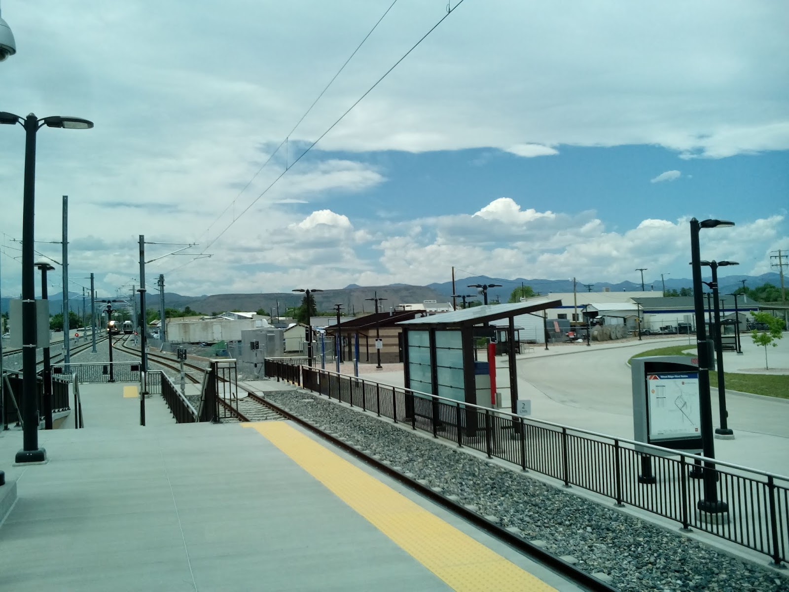
Most of my hike was through residential neighborhoods around Ridge Road. Here's a shot of one of the big commuter trains that serve the area.

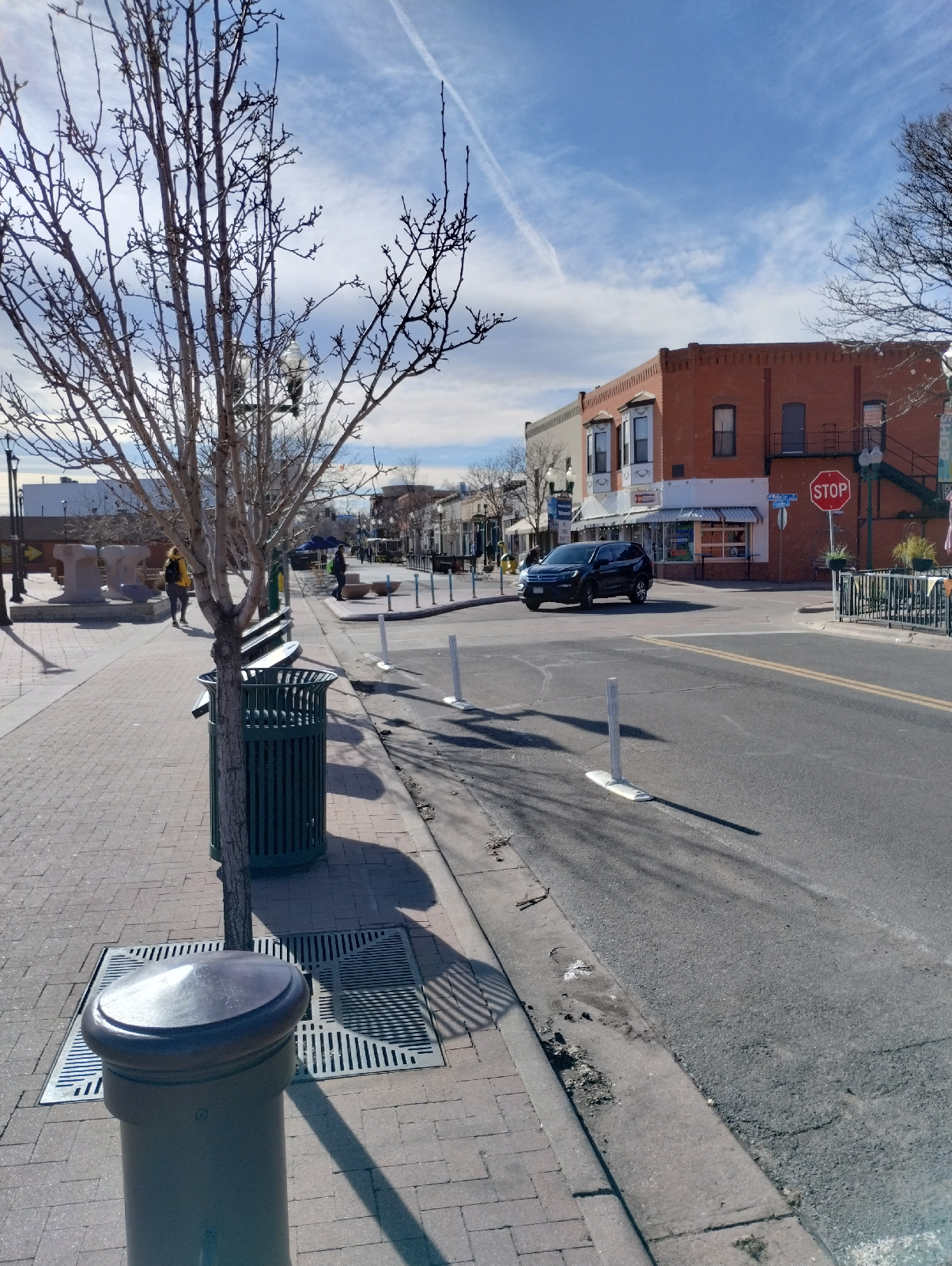
A sign that I was nearing the end of my short hike, this water tower marks a "slice of small town America" called "Olde Town Arvada". Technically, a large area of the northwest Denver Metro area is Arvada, Colorado but there area parts of the region that are more recognizable as a town ..here and to the north near Broomfield. Sometimes it's hard to tell if it's Arvada, or Westminster, or maybe Lakewood.

Anyway, Olde Town is the only actual tourist attraction on the G Line. It's intended to capture the atmosphere of "turn of the century" (I assume early 20th Century) Main Street America. With the diverse shops and proximity to the railroad station, it does seem to draw people. I've never been there when there weren't kids playing in the street (The main street is barricaded against traffic) and folks eating outside the restaurants.

To maintain it's purpose as a historical site, there are interpretive plaques placed around that explains the importance of gold, agriculture, and the railroad for the region.

The train station itself looks pretty modern.

There's also the only public restroom I've found on the G Line at the station (except for the restrooms at Union Station.)

I ate a massive roast beef sandwich at Lloyd's and visited Scrumptious for a milk shake (there are a lot(!) of places to eat at Olde Town Arvada) and then waited for the train.

There are very few places on Earth that hasn't been touched by humanity and they all have bragging rights. Arvada holds the distinction for once being the Celery Capital of the World and the site of the first gold strike in Colorado. What is your area proud of and how do they show it?

Place names have meaning to people (if it's only "my home town"). Arvada was originally named Ralston Point for the person who made the first gold strike but was renamed Arvada after Hiram Arvada Haskin, brother-in-law of the settler Mary Wadsworth, wife of Benjamin Wadsworth, first postmaster of the area after which Wadsworth Boulevard was named. The town was renamed to distinguish it from all the other places named after Rolston.  Where did your town (or region) get it's name?

I'll get to look at that site of the first gold strike in Colorado on the next hike and there'll be a lot of Rolston.

Monday, March 27, 2023

Wheat Ridge Station to Arvada Ridge Station: The G Line

G stands for "gold".

RTD's G Line runs near the place where Colorado's first gold strike happened.

I'll get there but first there are two legs of the journey to accomplish. I visited the Wheat Ridge-Ward Station, the western end of the G Line back in July 1, 2919 (http://adventuringbcc.blogspot.com/2019/07/terminus-wheat-ridge-im-not-going-to.htmlhttp://adventuringbcc.blogspot.com/2019/07/terminus-wheat-ridge-im-not-going-to.html). Then, it was just to look around the station. Now, I begin a new series of station-to-station hikes from Wheat Ridge through Arvada to Union Station in Denver. There are six stations.

My point of departure for each of these hikes will be Union Station in downtown Denver. The G Line is one of the northbound rails that board in the train pavilion at the South side of Union Station (the southern rails use the light rail station to the north).

Union Station Train Pavilion

Still electric cable cars, these trains are larger than the light rail trains that run south of Denver. These look like trains, and the passenger areas are cushy and roomy.

These trains are also commuter trains first. Many of the people who work in Denver live in these northern suburbs. Situated on the plains, there isn't a lot out here other than residential areas and industries. The stations are further apart and there are fewer attractions.

Geologically, it's still the Dawson-Denver-Arapahoe formations, the same that make up the land in Centennial, where I live...dirt from the debris washed out of the Rockies and the Ancestral Rockies and volcanic dust blown from the west during the Colorado uplift. It's a lot of dirt and mud, but good for plants. Arvada is the area's main agricultural region.

The main highlight for me at Wheat Ridge is the view of North Table mountain and it's basalt cap.


And the other mountains around Golden.

The Station is the end of the line for the G Line. A little to the west is Ward Road that has a few amenities, like a convenience store.

The art at Wheat Ridge-Ward Station is a piece by Michael Clapper called "Anchored by Place".

For rockhounds, the G Line offers dirt, mud, and landscaping boulders and gravel. I'm not dismissing gravel, such as railroad ballast. I've found some nice materials in gravel, like these feldspars.

But don't mistake them for indigenous minerals. There's no telling where they came from. You can try panning gold from nearby Ralston or Clear Creeks but good luck and remember that these are now urban Creeks and are likely polluted.

The views along this route are urban prairie and consist mostly of residential and industrial areas. On the train out, I noticed a lot of industrial sprawl and kept wondering, "how am I going to get around all this." Well, part of the draw is the puzzle of navigating these urban landscapes. My smartphone map utilities will be my friend.

To adventure!

By the way, do you know how to use the map utilities in your smartphone browsers? For wilderness navigation, understanding the lay of the land and celestial navigation is your best bet, but for urban navigation, minding the streets and city maps will get you where you want to go 

Most smartphones will use GPS to locate your current position and put you on a map. If you need more help finding your way around, the Directions function in the Maps section of your browser should do the trick. Learn how to use them. 

Monday, July 1, 2019


--- Terminus: Wheat Ridge ---

I'm not going to recommend the Wheat Ridge/Ward Road Station for tourism. The G Line that services the station is rather unspectacular with the exception of the Arvada Olde Town Station that looks like a nice place for shoppers that like quaint little villages. It has that feel. But my target was the terminus in northwestern Wheat Ridge, the only RTD light rail station in Wheat Ridge.

The G Line runs through a corridor of industrial zones and the Wheat Ridge/Ward Station is no different. It is surrounded by industry, but it does have some interesting points.

The station itself has parking for 290 cars and is a clean, attractive site. It isn't far from the foothills of the Rockies and especially offers some nice views of North Table Mountain. I was tempted to hike on over to the mountain but I'm not as familiar with that area as I am some parts of the Denver Metro area and I might have been disappointed by the real distance (as contrasted with the apparent distance) and lack of access to the mountain. Anyway, I am planning to visit the mountain in a couple of years when I look at the geology of the area.


                          [Photos of Wheat Ridge/Ward Station and the Rocky Mountains beyond]

One thing that I like about Colorado is the variety of showy wildflowers here. In the Southeast, most of the nice indigenous plants were woodland flowers and one had to do some hiking to see them. Here, any vacant lot may be a home to some pretty plants. One common plant with showy flowers is the thistle. Colorado has 15 native species and 5 non-native species, loved by bees and butterflies, browsing wildlife and wildflower enthusiasts. The one I found in the grassy burm of the light rail station is (I think) a nodding thistle (or musk thistle), considered a non-native, noxious weed.


                                                                     [Thistle]

As much as Denver is associated with the mountains, it's still a plains city and the great variety of grassland grasses are represented here. This foxtail barley is pretty common in the area. We have lots of it in our back yard.

                                                                  [Foxtail barley]

The stations of the RTD are micro-museums. Many of them display narratives of their neighborhoods. At Wheat Ridge/Ward Road you can read about the relationship between Denver and the mountains....and gold. G, in the G Line stands for "gold". The windscreens at the stations on the G Line tells the story of gold.

The artwork at Wheat Ridge/Ward Station is a modernist sculpture called "Anchored by Place". It was created by artist and art educator Michael Clapper.

                                                                [Anchored by Place]

You can read a lot about the stations of the RTD light rail, their art, including the windscreens, and stories connected to the stations and their neighborhoods at the FastTrack website, http://www.rtd-fastracks.com/main_1 .

If you follow me in my adventures and want to check out any of these places, you can prepare by going to the FasTrack site.

After wandering around the station, I walked down to Ward Road and a convenience store where I picked up a snack and then returned to wait for a train for my trip back home.

Along the way, I noticed this clump of a favorite wildflower, milk weed. Despite it's name, it's a gorgeous flower. Monarch butterflies will only lay their eggs on this plant. Check out the Fish and Wildlife website (https://medium.com/usfws/spreading-milkweed-not-myths-5df8c480912d ) to clear up misconceptions about this valuable plant.
                                                                        [Milkweed]

Ward Road has some nice views of North Table Mountain. The two Table Mountains are the exposed innards of an ancient but dead volcano. Their volcanic origin is made quite clear by the basalt deposits around the crown. Basalt is a dark, fine grain rock that is formed close to the earth's surface. It hardens too quickly for the melted magma to form large crystals like granite. These unearthed bones of dead volcanoes are sometimes called "fossil volcanoes". Luckily, they're as volcanic as the Denver area gets.


                                                            [North Table Mountain]

Regardless of how boring any area looks, if you look a little closer, you can usually find fascinating facts right in front of you.