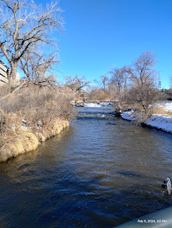
I have an app on my phone called "Flow Alert" (by Shaina Schwartzel) that lets me keep up with the streams in my area. Since Cherry Creek is somewhat more variable than some of the Creeks in the area and given to flash flooding, I check it before I hike the Cherry Creek Trail. It spiked from 64.7 cubic feet per second flow to 125 cfs on the 10th of this month (February).
I began this hike behind Cherry Creek Shopping Center, the big shopping district on University Boulevard. As shown above, Cherry Creek is a respectable stream here.
There are several of these weir dams along the length of the creek. They're pretty and produce a nice rushing sound but they're obviously man-made and the primary purpose is erosion control. The average flow rate of 23 cfs with a range from 3 to 146 cfs isn't too shabby and has produced a considerable valley. In fact, the Valley Highway (I-25) runs along the rim between the South Platte River and Cherry Creek Valleys. Cherry Creek flows it's full length down into the Denver Basin.
Off to the left of the photo, out of sight, is a man and his dog throwing duck food to the duck convention. Local residents make this stream especially popular with water fowl.
The Four Mile House was built in 1859, making it the oldest surviving structure in Denver. It was the last way station on the Wells Fargo Butterfield stage coach route between El Paso and Denver. People would stop there to freshen up before entering the big city of Denver. It was, of course, four miles from the terminal stop.
There are exhibits and, if you plan you might catch one of their many events. Of course, they have a website to help you plan
And there is an old wagon there to remind you how wonderful transportation was back then.
Some people call these Conestoga wagons but "Conestoga" is a specific brand of wagon. They were huge, heavy wagons built to carry tons of supplies and they were almost completely used in the Eastern United States. By the time folks were traveling west, these smaller wagons were the common conveyance. They were basically farm wagons with a cover.
This long, straight section of Cherry Creek was the last on this hike and lead me to Monaco Boulevard where I caught a bus to the Southmoor Station and then a train home.
Waterways have always been the lifeblood of cities. Does your town have a stream nearby and does it serve a purpose for the people living there: drinking water, irrigation, transportation and commerce, sewage....


