Monday, October 16, 2023

Anatomy of a Mountain Range 2: The geological spectacle of Red Rocks


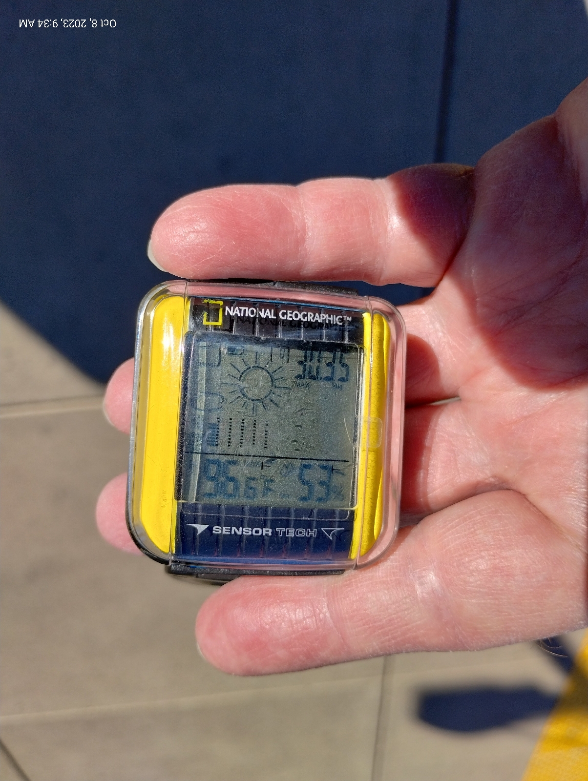
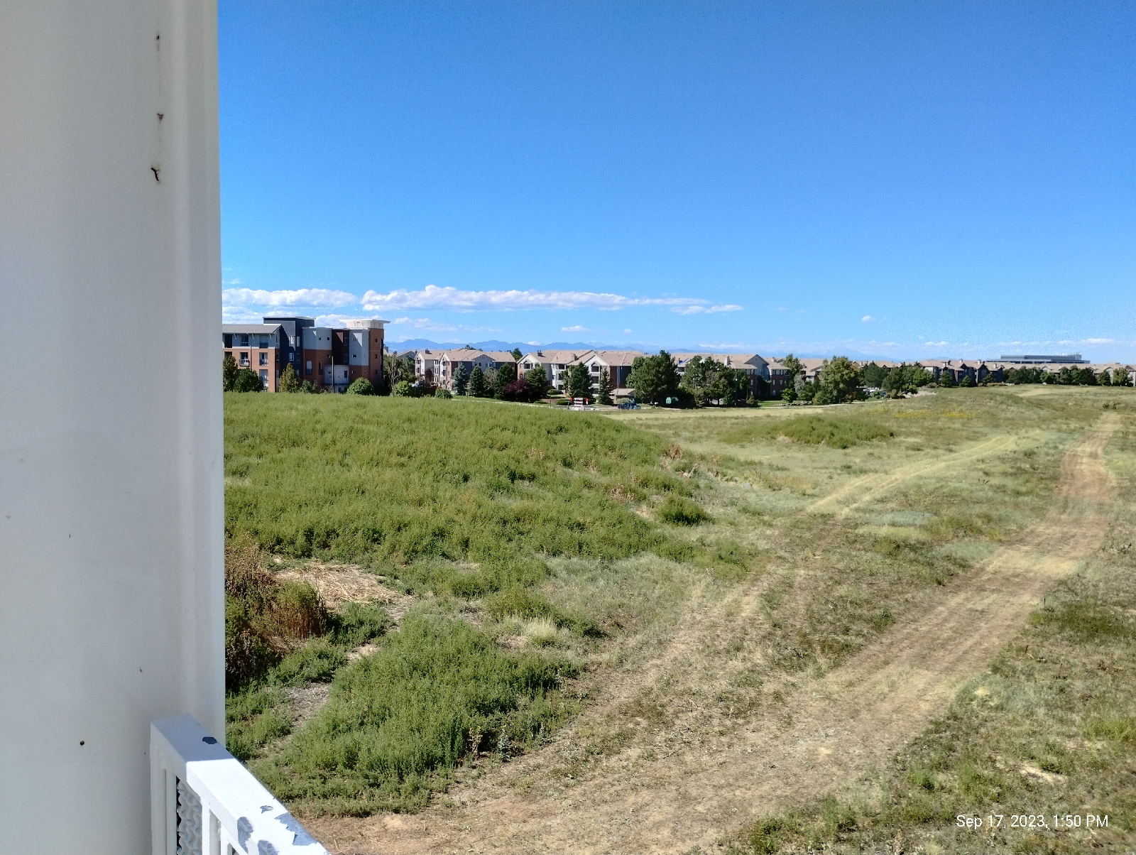
I made these recordings at the Phillips 66 in Morrison at the start of my hike. The weather is holding steady but it's warming up. My sweater has long ago gone into my backpack. The altitude is actually below that of the light rail station at Broadway. That's not surprising since the train station is up above the South Platte River. Morrison is nestled down in the Bear Creek Canyon. I'll be hiking up a lot for awhile.

To the right is the valley cut out by Bear and Mount Vernon Creeks. They flood occasionally so it's a fairly broad area. To the left is the rise to the Rocky Mountains. Here, that would be Mount Morrison and Mount Falcon.
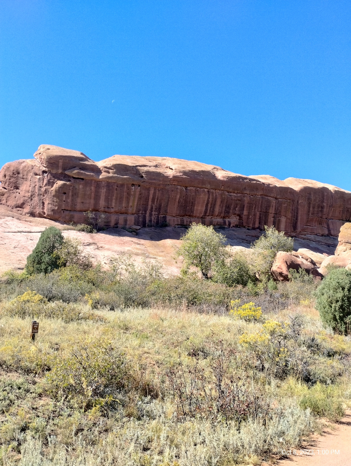
These huge chunks of Fountain formation rock are arkose sandstone. What makes them "arkose" is the large amount of feldspar still in them. What gets eroded out of mountains is usually the constituents of granite - quartz, feldspar, mica, amphiboles, pyroxenes. And small amounts of other stuff. The stuff washed out of the Ancestral Rockies obviously had a lot of dark, iron-bearing minerals such as biotite mica and amphiboles. That's where the red rust comes from when they fall apart chemically. But the feldspar usually goes to clay and quickly gets washed downstream. For there to be feldspar left, the sediments must have been washed out very quickly, deposited close to their source, and buried so that the process of consolidation can begin sooner than later.

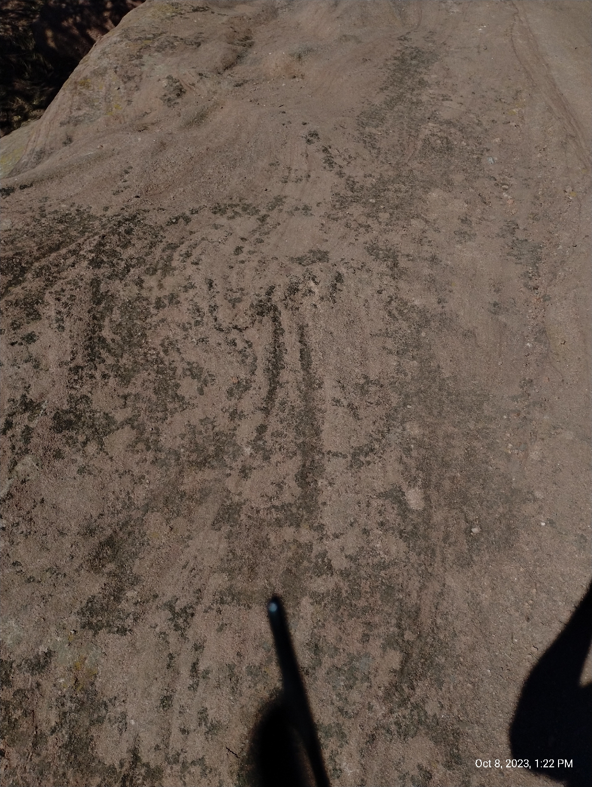
There's something else you can see here. Those pockmarks in the rock are called "tafoni" or "honey comb weathering". They're fairly common in desert environments. In really wet places, water just grinds away at rock faces willy-nilly and wears them down large scale. Here, water seeps into the permeable rock and finds weak spots. That's where it starts chemically weathering the stone...in spots.

The sandstone particles are tough because they're cemented together with calcite, but calcite is soluble in acids, and dew and occasional rain is weakly acid from the carbon dioxide it has dissolved. That's how caves form in limestone, which is primarily calcite. In sandstone, the quartz particles (sand) just fall out to form these little holes and horizontal and vertical joints.

The wind and moisture isn't in any hurry to do widespread damage so they can be artistic, carving out these spectacular rock sculptures.
There are a couple of streams in the neighborhood. Bear Creek is a picturesque mountain stream draining the area around Mount Blue Sky. It comes in crashing in from the west having cut out it's canyon. Mount Vernon Creek is a smaller, lazier stream that pours in from the north skirting the edge of the hogback. Most of the streams in Red Rocks Park are like the one shown above...dry until it rains. They're called "draws". This landscape would fit right in with any John Ford western.

Typically, the Fountain formation show up as "standing stones". They look like they were arranged by some giant child marching off into the horizon. Now you know why. They're the shell of the Rocky Mountains, cracked open as the present Rockies were born. Most of the red sandstone on top have long ago been weathered to nothing but there are still some places in the mountains where there are remnants such as Red Rocks Campground, near Woodland Park, west of Pike's Peak.

This is a view south on the Trading Post Trail that runs from a parking lot near the South Entrance to the park to the Trading Post/Rock and Roll Hall of Fame Museum at the base of the amphitheatre.

The lower part of the trail is loose rock and sand deposited by present streams, mostly flooding by Bear Creek, but near the amphitheatre, the flat rock is Fountain formation, giving the hiker an opportunity to see Red Rocks closeup. These ripples are cause by the same weathering that creaked the tefoni in the standing stones.

That's part of the amphitheatre peeking out from behind the little tree. I followed the Trading Post Trail up and around to the grueling stairs up the side of Red Rocks Amphitheatre called the Funicular Trail, which leads to the upper parking lot.

When Red Rocks Park was first built, there was a funicular railroad that carried visitors to the summit of Mount Morrison for a grand view of ...well, everything....mountains, canyon, plains, Red Rocks. To get up there now, you have to hike, but the stairs will get you part way if your knees and lungs hold out.

At the upper parking lot is this...
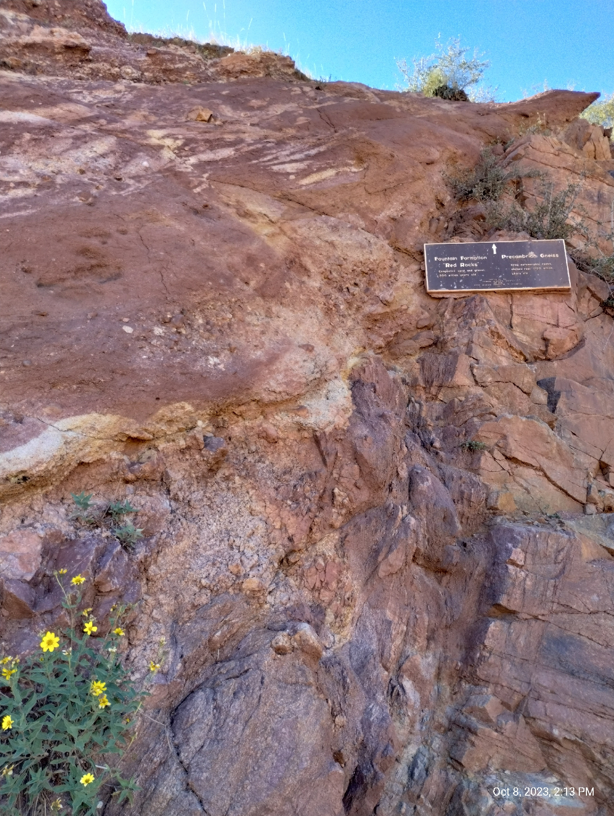
This is the mystery I promised you at the end of the last blog. At the breadth of a finger is a gap of over a billion years!

It's called the Great Unconformity. The red Rocks on top are the 300 million year old Fountain formation. They sit directly on top of 1.7 billion years old rock of the Idaho Springs formation. What happened in between?

The grayish rock at the bottom is metamorphic gneiss and it's older than the land that would become Colorado. Over a billion years ago a chain of volcanic island crashed into the North American plate and stuck. Rocks like this were lifted with the rest of the Rockies during the Laramie orogeny to become the core of the mountains. 

But what happened to the geologic history of over a billion years? Nobody knows for sure but the most popular answer I find reading about the Great Unconformity is erosion. Something scraped all that accumulated debris off the core rock 400 million years ago. 

Of course, the erosion that formed the Fountain formation razed the Ancestral Rockies to level plains. The sediments above the metamorphic and igneous core of those ancient hills simply washed to the sea. As the hills came down and their slopes leveled out, the sediments were deposited closer and closer (gentler slopes meant slower water currents) until the erosion met granite and gneiss and the sand was laid down right there in what would become Red Rocks Park.

But some geologists find even that to be a weak explanation for the elimination of a billion years of strata.

A tantalizing theory is that the great eraser, glaciers, did it. About that time is when some geologists speculate that Ice covered the Earth, a time they call "the snowball Earth."
West Alameda Parkway begins in Aurora (East Denver Metro) at the Buckley Space Force Base, runs through Denver (one of my favorite shopping areas is around Alameda and Broadway) and ends at the top parking lot of Red Rocks Amphitheatre. In fact, Dinosaur Ridge is a closed off section of Alameda. It passes through a tunnel in a big chunk of the Fountain formation and, not long after, the Plains View Road splits off to the left and leads to the Geological Overlook Trailhead. That looked inviting so I took the bait. It wasn't long before I realized that, if I wanted to make it to Golden before night, I needed to turn back, but before I did, I took a few shorts from a high point (the trail climbs up about a third the distance to the summit of Mount Morrison.) The photo above is one of them.

The two hills in the distance is the mouth of Bear Creek Canyon and just beyond is Bear Creek Lake and Mount Carbon.
This is a view back down to the amphitheatre and Mount Falcon beyond.
Here's some more of that chemical weathering. It gets pretty extensive in some of the areas in Red Rock Park.


A little further north on Alameda Parkway I find the other end of the Geological Overlook Trail and realize that the overlook itself is just off the road, so I take another picture. There's a big sign there that tells you what you're looking at but it was crowded and I try not to get recognizable pictures of people without their permission, so I just got a panorama from the side.

A little more roadwork brought me to Dinosaur Ridge, and that will be the main subject of the next section of Anatomy of a Mountain Range.

Sunday, October 15, 2023

Anatomy of a Mountain Range 1: Morrison


October 8 (it's been awhile but I completed this blog and then it vanished so I had to do it over) I started out as usual for Arapahoe Station. This photo at the junction of Arapahoe and Yosemite shows a clear day that promises good weather for a long, strenuous hike. I wasn't disappointed. The actual hike began two trains, a bus, and a Lyft taxi later.

56 degrees and 53% humidity. Woof! 

I took some measurements to compare with measurements at the start of the hike while I waited for the second train at Broadway Station. The barometric pressure was up and stable. I had a sweater on but it wouldn't stay on for long. 53 degrees is pretty warm for me, given this untempered Colorado sun.

Mount Morrison is front and center. It's the first actual Rocky Mountain near Denver. The rest, Green Mountain, the two Table Mountains, Mount Carbon, the Dakota hogback, Red Rocks, are all foothills.

Here's a closer view from the Wadsworth Park and Ride where I waited for the taxi. Red Rocks Amphitheatre is right there.
The big rock on the right is Creation Rock and the one on the left is Shiprock.....uh, or is it the other way. Honestly, the names have swapped so many times I can't keep up with them. But they are red. The reason they don't look red is that phone cameras add blue to pictures to make them more presentable. Like most red in nature (some exceptions are cinnabar, rubies colored with chromium, cuprite, and red flowers and leaves), Red Rocks are red because of iron, specifically hematite (aka rust).
I usually enter Morrison on the Bear Creek Trail on the south side of Morrison Road, but the taxi let me out at the Phillips 66 on the north side and I noticed that there was a footpath that skirts the base of the road cut, so I took that. It was a good choice for a closeup view of the Dakota hogback.

It's called the Dakota hogback because it's capped with erosion resistant Dakota sandstone. Actually, it's layered with other stuff like this volcanic ash from an ancient volcano far to the south that blew it's top about 100 million years ago. Take note because you'll see it again. The hogback is a star of this hike.

During the Cretaceous period, around 100 to 95 million years ago, an interior seaway opened that split North America in two. Rise of sea level and erosion of gradients to the east and west slowed river flows, for instance, from hills to the west in what is now, Nevada and Utah, causing them to dump fine sediment along their routes and into the inland sea. This compacted to form the sandstones, clays, mudstones, and shales of the Dakota formation. 

These rocks are widespread in North America, from Canada to Mexico and from Iowa to Nevada. These slow moving streams and swampy lowlands were host to a lot of life, big and small, and when that life died, provided an excellent environment for the production of fossils. Dakota rock is a rich source of many of the dinosaur skeletons that grace natural history museums of the United States today.

Climbers were out on the anticline this day. An anticline is a mass of rock that has been folded upward. The Dakota hogback ("hogback" because it reminded someone of the ridge along the back of a wild pig) is the result of the same mountain building event that raised the Rocky Mountains. A little further east, the rocks folded downward forming a big bowl, a syncline, the Denver Basin, that filled in with the sediments from the eroding Rockies. I remember that a syncline is a downward fold because "sync" sounds like "sink" and an anticline is...well, the opposite.

This road cut through the hogback is also the mouth of Bear Creek Canyon which opens up the Rockies back to Evergreen and the area around the base of Mount Blue Sky, third highest mountain in the Front Range. You can see it as the gray mountain in the distance in the photos at the top of this blog. It's gray because the peak is above the timber line, over 14,000 feet. No trees grow in the thin air and top soil up there.

The trail that parallels Morrison Road through the road cut let me out at the eastern border of the busy (always busy) tourist town of "historic Morrison", home of interesting shops and good places to eat. It was too early for my favorite burger place in Morrison, the Mill Street Inn, so I went across the street to The Cow for a milkshake. As I get older, I rarely eat real meals on hikes anymore. I focus on drinks to prevent dehydration. That's a major concern in dry Colorado.
Maple Street, across the road, heads up to Red Rocks Elementary School. I wanted to check out the intersection. Morrison Road passes through town through the mouth of Bear Creek Canyon and turns south there between the hogback and Mount Falcon. (The small but excellent Morrison Natural History Museum, home of what's left of dinosaurs, is down there.) Bear Creek Road branches off west toward Evergreen.

Several formations come together here.

The Dakota formation continues out under Morrison which is built on much younger unconsolidated materials of the Post-Piney Creek and Piney Creek alluviums, material that has been laid down by modern streams, mostly Bear Creek and Mount Vernon Creek, which parallels the hogback to the west.

Just before the intersection, the Lykins formation shows up as brown, iron rich sedimentary rock.

I guess this is a good place to introduce the rules of sedimentary succession. They're pretty intuitive and are important for dating rock....before radioactive dating it, and the identification of certain characteristic fossils, were about all that geologists had to build the geologic time scale.

The Law of Superposition: Younger formations are on top. That makes sense. They were the last sediments to be laid down.

The Law of Original Horizontality: Sediments are initially deposited horizontally. Gravity dictates that. That big anticline in the pictures above was originally flat as a pancake.

The Law of Crosscutting Relationships: If a layer cuts diagonally across rock, the crosscut is more recent. The younger rock cut through rock that was already there.

The Law of Lateral Continuity: If you see a layer in one part of a formation, don't be too surprised if you see it again miles, many miles, down the road in the same formation. It'll be the same layer, the same age.

These principles were first recorded by the 17th century Danish geologist Nicolas Steno, so they're also called Steno's Laws.

The Lykins formation lies atop most of the others in the area (except the debris piled up by the present day creeks) so it's very young by geological standards. About 250 million years old, the Lykins formation shows as a thin band of clay, mudstone, and limestone just west of the Dakota hogback. In places, it's banded, displaying it's only fossils, the sticky algae that were about the only thing that could grow in the muddy swamps of the Permian and Triassic boundary of the region. The Lykins limestone is responsible for many of the few caves in Colorado, like the ones around Manitou Springs near Colorado Springs.

Just west of the Lykins rocks the stone suddenly shifts to the red arkose sandstones of the Fountain Formation that made Red Rocks famous. It also makes up the spectacular scenery of Boulder's Flatirons and the pinnacles of it's Red Rocks Park, the standing stones of Roxborough State Park, Colorado Spring's Garden of the Gods, and even the big rocks scattered around Woodland Park's Red Rocks Campground, west of Pike's Peak. The Maroon Bells on the western slope of the Rockies are also of the Fountain formation.

You see it here as the red stone overlaying harder blonde sandstone. The Fountain formation is around 300 million years old, composed of material washed out of the Ancestral Rockies. It pretty much blanked the area where the older mountains were and when the current Rocky Mountains were uplifted by tectonic forces of the Pacific plate crashing into the North American plate far to the west, the shell of hard sandstone was cracked and pushed skyward, often standing on end.

The blonde sandstone is of the Lyons formation. You can see it in the walls of the buildings of the University of Denver campus in Boulder and the buildings and restraining walls around the Denver Tech Center. The hard sandstone that naturally breaks into sheets is a beautiful, durables, and popular building stone. It's about 280 million years old and....

Wait a minute! Aren't younger stones supposed to lay on top of older stones? 

Well, yeah, generally, but sometimes things get flipped over and then you have to look for an explanation. This one's easy. Like I said, when the Colorado Plateau was uplifted to form the Rockies, it stood the Fountain formation on end, then the inexorable erosion continued working on the new Rockies, actually burying them in their own debris. This stuff formed the Lyons sandstone. Notice the slope of the blonde sandstone. It keeps rising upward until it is above the Fountain formation.

This sharp boundary between very different stones signal a fault. It's not always easy to see faults because they're usually covered by loose soil and alluvium but here it's clear.

Below the Fountain and Lyons formations is a big (big!) surprise. I'll show it to you in the next blog (wait for it!).


Monday, October 2, 2023

From Southmoor Station to Yale Station

What happens when you cross one stream with another? You get one stream...except when you don't.

 Sunday's station-to-station hike started and ended with a supply run. That usually happens at the first of the month when I have money. The above photos are of a city park....certainly not a nature park.

It's sorta pretty in a geometric way and people do walk their dogs there. 
Another requisite shot of the Rockies, this time from Alameda Station. It's a panorama so you'll have to blow it up for details, but it illustrates why I like these vistas on the light rail on the way to hikes in the mountains.

This one shows the Front Range and foothills from Golden to Long's Peak far to the north. That's Green Mountain in the left center between the two lone trees.To the right of that are the two Table Mountains (you can identify them by their sloping flat tops with what looks here like a lighter layer on top.) Further to the north are the mountains between Golden and Boulder including The Flatirons. The jagged peak in the distance is Long's Peak.

Taking a train back to Southmoor Station, I retraced my path from the last station-to-station hike to rejoin Goldsmith Gulch on Yale. Remember the last time, the gulch had gone underground to flow past a shopping center. This is where it resurfaces from under Yale  It looks a lot like a drainage ditch....mainly because it is a drainage ditch.
Denver Metro keeps it's drainage ditches pretty presentable. They usually host parks and footpaths.
The Highline Canal crosses Goldsmith Gulch in James A. Bible Park. Intuitively, there are only two ways that two streams can cross and remain two streams. One stream can cross over the other on an aquaduct. That's what happens here. It's an interesting aquaduct. It doubles as a bridge carrying the Highline Canal (currently dry), a road, and a footpath over Goldsmith Gulch.

The other way is for one stream to go under the other at a syphon. That's how the Highline Canal crosses Little Dry Creek, and further south, Plum Creek.

You would think that, when two streams meet, one will dominate the other, the stronger current capturing the flow of the other stream with silting building up the bank of the stronger stream..

Strangely, as this website indicates:


There are two places in the world where streams do cross. At Wegroweic, Poland, the land is flat and where the two streams meet, a vortex is set up that spins the waters out so that only about 10% of their waters meet. I've mentioned that at confluences, waters of the separate streams often remain separate for some distance downstream from where they meet.
The two streams are so evenly balanced that they cross and continue on their separate ways.

The Highline Canal (I have several blogs featuring this stream, which is a very interesting feat of engineering. Just check the Blogger search bar at the top of the Home page) crosses several other streams, both natural and manmade, on it's 71 mile long journey from Watertown Canyon through the Denver Metro area.

In case you're wondering who James A. Bible is, he worked for Denver Parks and Recreation for 50 years and, when he retired, they threw a party for him and told him they had named a park after him. 

There are chainsaw sculptures at both ends of the aquaduct created by an artists who called herself Chainsawmama. Her real name is Faye Braaten and her work is gorgeous.
The walk from Bible Park to Yale Station isn't long but the end isn't visible until you top a rise between. The Highline Canal is so convoluted that it crosses Yale three times on its way north. That's Mount Morrison and Mount Blue Sky in the distance. The bridges are the Valley Highway (Interstate 25) and the RTD light rail.

There's Yale Station and my destination. I usually approach it from the other side, often shopping at the stores on Colorado Boulevard and my dentist is down the hill, also. I will hike down there for my next station-to-station hike.
Yale affords a lot of good views of the mountains.

One of the grand RTD murals is on the platform wall of Yale Station. 
"Connected" was painted by artist Gregory Gove in 2006. 

Sound barriers and walls in this section of the light rail are embossed with what looks to me like a ticket. I'm not sure what they portray but it might be willows, Blue Gramma (the state grass), and/or maybe locust trees. Anyway, your guess is as good as mine.
After finishing my hike, I headed over to Englewood Station and the nearby Walmart to pick up some supplies. By the time I returned to the station, the sun was setting and the cross on Mount Lindo was lit.
It marks a cemetery on one of the mountains near Conifer. I will have to visit it some day. Views from the summit are supposed to be breathtaking.

The next blog will be an anatomy of the Front Range, a long hike that brings it all together. It'll be a long one so the write-up will take some time. See you then.


Sunday, September 17, 2023

Bellevue Station to Southmoor Station


I'm back on the high plains for this hike. I've spent so much time west of the Valley Highway (Interstate 25) that I've decided to focus more on the Cherry Creek Valley, east of the highway, for a while.

The above shot was taken on my outward journey, at the Arapahoe at Village Center Station. The premier plant on the plains, either wild or cultivated, is grass but the variety is so outstanding, it shouldn't be overlooked. These plants are almost certainly cultivated pampas grass planted in the margin of the station plaza right next to the tracks but the whole scene grabbed my attention so I took the photo for a lead-in to the blog. (East of the interstate, the valley highway blocks clear views of the mountains so don't expect any breathtaking vistas this time.)
I don't know what causes the bumpy land on the north side of Union Avenue from Bellevue Station, whether the bumps are natural or manmade. The area is used as a park for the residential area nearby and one of the mini-mesas has a picnic table on top. I wonder if the mysterious mound at Arapahoe Station is just one of these hills that has been landscaped.

A mesa is generally a flat topped hill formed by weathering and erosion. The Table Mountains in Golden area are sedimentary rock topped by an erosion resistant cap of an ancient lava flow. Green Mountain, between there and Denver is just an erosion feature carved out of the layered sandstones and mudstones of the bedrocks underlying the Denver area. Mesas are a typical feature of desert areas, carved away by wind and water, less by streams than by the direct action of falling rain, dew, and water that seeps up out of the ground.

The Denver, Dawson, and Arapahoe formations are mainly sand and mud stones but there is certainly variation in density of the rock and, so, the ground can be expected to erode at variable rates. I can imagine these hills being the result of that process.

This view from the Union Street bridge next to Bellevue Station is the best I could do for a requisite shot of the Rockies on this hike. From here, I'm headed east.

I catch up to Goldsmith Gulch at George M. Wallace Park, which borders the DTC Parkway. Not to be confused with the Alabama governor, George M. Wallace is a developer considered to be one of the founders of the Denver Tech Center. The park is a big lawn with picnic tables and benches that provides an outdoor recreational area for the surrounding developments.

Goldsmith Gulch goes underground at Interstate 225, a Denver perimeter bypass, and the RTD H/R light rails. It reemerges on the other side near Rosamond Park.

These are very urban parks, manicured and all that, but they do have some small draws for the naturalist. I'm pleased to see my (and the Monarch butterfly's) favorite wildflower growing in abundance. I usually show the blossoms but, to the plant, the seeds are all important, so ..
I'm sure one of the milkweed 's secret to success (I have never been to a place where it isn't) is the fact that so many seeds are spread by the wind.

These guys are there, too. You may have noticed from my past blogs that we like our prairie dogs.
By 2:00 I had to see just how badly I was overheating and was surprised to see that the air temperature was only 88° F. The humidity was sorta high for a desert town, 41%, but the real culprit was that blazing Colorado sun. If you aren't from Colorado and decide to visit, don't underestimate it. Heat, dryness, and altitude can be a deadly trifecta.
By Rosamond Park, the gulch has grown considerably. 

The surface of the park is mostly loess and the colluvium that is so common in the area. "Loess", by the way is pronounced "less". It's a soft rock formed by sand, clay, and/or silt deposited by the wind. Geology students are reminded of that by the phrase, "more and more of loess and loess." 

Most of the material around the stream was deposited by it...and the folks that constructed it, of course. Those rocks weren't born there.
This mudstone is a rare outcropping of something that actually belongs there...real bedrock! Muds often dry and compact into layers like this. The platey molecules, which are generally complex, tend to want to bind more strongly to those next to them to form sheets. The sheets are held together by weaker forces that become even weaker when dry. The polar attraction between water molecules go away. This stuff ends up being sedimentary mudstones and, if subjected to stronger forces and heat becomes shale, and then metamorphic slate.

This, believe it or not, is Goldsmith Gulch. It goes underground beneath that shopping center and then emerges across the street to continue it's journey to Cherry Creek. I left it here to follow Hampden Avenue west to my destination.
A car wash shaped like a river boat in the high desert. That's.....novel.

Like many of the light rail stations, Southmoor's parking lot is across the interstate from the train platform. The two are connected by a tunnel under the interstate. There used to be light columns along the walk that lit up and made an audible tone as you walked by. As Stephen King says, "the world has moved on."

There are residences behind these walls. From Southmoor to Broadway Station, there are noise barrier walls around long stretches of the light rail and Interstate. They're decorated with Colorado scenes. The bison is, of course, an iconic animal of the plains. It's not an official symbol of Colorado. The bighorn sheep is the official Colorado State mammal. But they're impressive, historic, and there are still a few around in ranches and national parks, and, uh, zoos. They're conserved and maintained.

Ones skullcap popped off. It shut down one of the rails for awhile until they repaired it. There are also mountains featured....and squiggly lines...not sure what they represent.

Anyway!
I had a supply run to make in Englewood. The light rail station there has nice vistas of the Front Range.
My hikes often turn into multipurpose treks. Once I loaded my backpack with supplies, I headed back home.

Next time, I'll take a final look at Goldsmith Gulch (for the time being), the Highline Canal, and Yale Station.