Showing posts with label meander. Show all posts

Monday, April 3, 2023

Olde Town Arvada to Gold Strike Station

Confluence of Clear Creek and Rolston Creek

The very place of the first gold strike in Colorado.

Rolston Creek, Rolston Point (the earlier name of Arvada), Rolston Ridge, Rolston Road, Rolston Crossing, Rolston Station...who is this Rolston guy?

In 1850, Lewis Rolston, a prospector from Georgia stopped by this very place and panned a quarter ounce of gold out of the creek that now bears his name. They left the next morning on their way to California. In 1858, Rolston returned with another group and set up a placer mine at the same site...the first gold strike in Colorado.

Rolston was born in 1804 in South Carolina but later moved to Auraria, Georgia (after which Auraria, Colorado was named and from where many of the settlers of Auraria, Colorado came). He is also sometimes credited with starting the gold rush in Georgia after he collected a shiny rock in what would later be Lumpkin County, Georgia.

He returned east in his later life, served in the Confederate army and probably died in Georgia around 1870.

When the gold played out in Rolston Creek, many of the miners settled down to farm the area.

My trek started, as usual, in Centennial and I boarded the G Line train at Union Station in downtown Denver.

I detrained at Arvada Olde Town and relaxed for a few minutes with a milk shake. The statue at the station, Frank Swanson's Track Bone, refers to the railroad as the backbone of the community. It's carved out of Colorado rose red granite.

I joined Rolston Creek on the Rolston Creek Trail right in downtown Arvada.
Rolston Creek arises a little to the west in Golden Gate Canyon in northeastern Gilpin County. Rolston Creek Trail begins just north of North Table Mountain near Golden, Colorado and runs about 14 miles to the confluence of Rolston Creek with Clear Creek, where it joins the Clear Creek trail. Since these trails parallel the G Line to Pecos Junction, I'll be making use of them for a while. After that, Clear Creek and the G Line separate. The creek joins the South Platte River in Thornton. I would not want to hike back to Union Station from there 

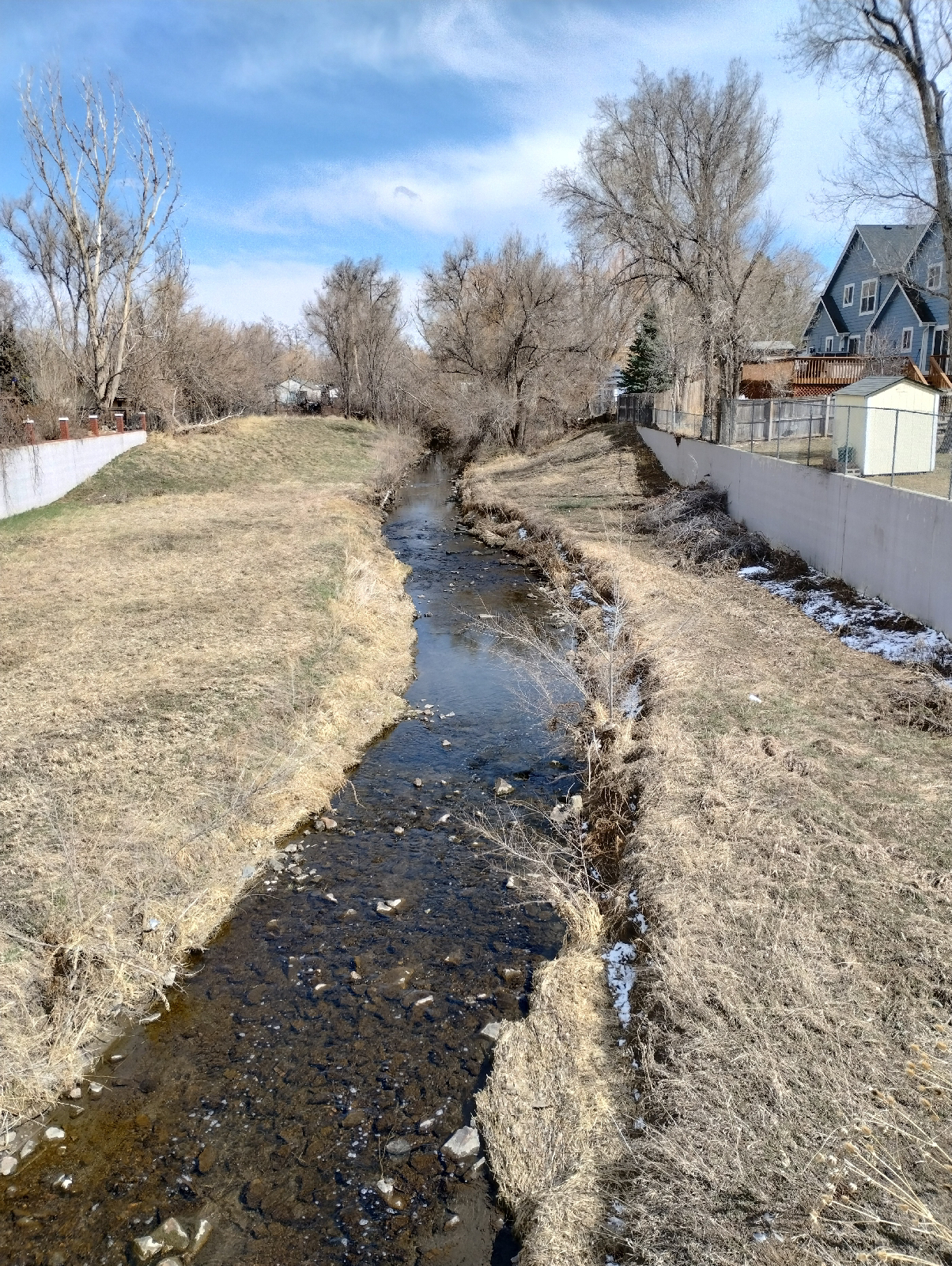
Clear Creek has enough energy to eat away at it's banks, so there's plenty of meandering. Oxbows aren't common around here. The land isn't quite flat enough for streams to go anywhere they want. But there are a few. One nice example is in the Carson Nature Center in Littleton. There were a couple of places on this hike where it looked like Rolston Creek might make oxbow lakes if left alone. With all the urbanization and industrial parks, there's little chance of that happening.

Oxbow lakes form when a meander is choked with sediment so that it's cut off from the rest of the stream. Check out maps of streams out on the plains and you'll find many examples 


Have I mentioned that Denver likes murals? These murals in Arvada are exhibits from the 2021 Arvada Babe Walls Mural Festival. 

I left the Rolston Creek Trail at the Gold Strike Park, which commemorates the first Colorado gold strike. Along with the interpretive plaque, there are a few pieces of placier equipment on display. I'll get back to this park on my next hike.

Getting from the park to Arvada Gold Strike Station required a little navigation around urban streets but it wasn't too complicated or far and it afforded some nice views of the commuter train...

and the mountains.
The station itself is pretty typical of these G Line stations.

How do the streams in your area differ in appearance than these in the Denver Metro area? What might account for their differences?

Gold prospecting was a trend in the U.S. in the 1800s. Was there a gold rush in your area? You might be surprised. Gold is fairly rare but is widely distributed. Do your homework and you might even be able to find some in your area.

Monday, February 14, 2022

How deep is my valley?

Sounds like one of those period dramas, doesn't it?

Of course, I'm still just going on about the Little Dry Creek valley a couple of blocks over from my house.

I've mentioned that the mountain streams in the Rockies are very different than the ones I knew as a child back east. Little Dry Creek, on the other hand, looks very familiar, but all streams have their own personalities. 

On the last walk down the hill, I took some side trips from the main road that parallels the creek, Arapahoe Road, down to the creek to get an idea of the cross sections. You remember that I took one elevation profile down Uinta Street a couple of blogs ago. I supplemented that with three others starting near the rim of the South Platte River valley and stopping at the western end of Walnut Hills, Quebec Street.

Little Dry Creek Park is near the head of the valley where the creek emerges from a culvert under Yosemite Street. On the other side is just storm drainage channels.


Here the creek cuts a shallow channel surrounded by a wide plain. In about 250 feet, there's only a rise of about 10 feet to the surrounding residences. I figure that the plain was carved by the creek because the rise up to the residences have been reinforced by stone to prevent further erosion in that direction.

The headwaters of Little Dry Creek is just building up energy and volume here. There's enough flow to have cut a shallow notch but it looks like it has meandered in the recent past. I doubt if there has been a lot of flooding. The flow has been erratic as shown by water level readings over the last year.

I was in the area in 2020 and 2021 and the maximum flow of 5 cubic feet per second was not enough to flood the creek's banks.

Much of the variance is due to snow melt and occasional spring rains. This data is from the area west of Walnut Hills where the creek passes under Arapahoe Road.

As the creek builds up energy and volume, it cuts a deeper valley with less meandering.

At Uinta Street, the valley drops into the hilly section behind Walnut Hills Elementary School. 

The elevation difference between the top of the hill to the bottom, at Spruce Street, is about 70 feet. The ridge passes through Walnut Hills. It's very visible on Arapahoe.

I would think that it's older than the creek...maybe a bump in the Dawson formation that appears as outcrops northeast and south of Walnut Hills. Regardless, the creek has cut deeply through the ridge. The whole length of the creek has erosion prevention features like small weir dams and boulders that have been moved into the stream bed so the back cutting has been slowed considerably.

I like trying to visualize what different places might have looked like before buildings were there. I wonder if there was a Cascade here.

At the bottom of this grade, Spruce Street crosses the creek.

The creek begins to meander again and there's a wider plain. They're also deeper banks. 

In 0.2 mile, the walk down from Arapahoe only descends about 40 feet. 

The creek begins cutting some fairly deep banks, some about six feet, close to my last stop, Quebec Street at the western boundary of Walnut Hills. These show some nice soil profiles, so I should be coming back later.

Here the valley is broad and the gradient into it is gradual. Over 0.2 miles, the descent is only about 30 feet. On the other side of Quebec, the valley begins deepening again, as shown in the photograph above shot through a fence. (The Little Dry Creek Trail pulls away from the creek for a ways to follow sidewalks around a residential area.)

I have only been looking at the creek valley in Walnut Hills neighborhood. The valley actually extends further on the other side of Arapahoe Road. The rim peaks about a half mile from the creek at Fiddler's Green. Little Dry Creek has slowed down considerably due to erosion controls installed with the residences of Walnut Hill, but it has evidently been much more active in the past 

Now, a few words about the AllTrails app. It's a great tool for measuring distances and elevations but it's not terribly intuitive, so let me give you a few tips. My version is 14.3.1 of AllTrails Pro and I use it on an Android phone version 8.0.0.

Use the Navigate command (the middle button on the toolbar at the bottom of the AllTrails window) to get to the tools. Choose "Start without a route" and choose an activity. Hiking or walking is good. Then just press the start button. When you reach your destination, press and hold Pause and the app will ask you if you are finished. Press Finish. It will ask you how your trip was. On my Android, the app has frozen at this point but, if you close the app and restart it, you will find your data saved in History. Later versions may fix this glitch and it may not happen on other operating systems.

Nevertheless, AllTrails is an excellent app to measure the shape of your landscape. There is a free version. The Pro version isn't expensive and provides more reporting features.

Before begining a study outside, it helps to get a lay of the land. What does your neighborhood look like? What does it contain - rocks, plants, animals, attractions, hazards, streams, hills... outcroppings,