Showing posts with label highline canal. Show all posts

Monday, October 2, 2023

From Southmoor Station to Yale Station

What happens when you cross one stream with another? You get one stream...except when you don't.

 Sunday's station-to-station hike started and ended with a supply run. That usually happens at the first of the month when I have money. The above photos are of a city park....certainly not a nature park.

It's sorta pretty in a geometric way and people do walk their dogs there. 
Another requisite shot of the Rockies, this time from Alameda Station. It's a panorama so you'll have to blow it up for details, but it illustrates why I like these vistas on the light rail on the way to hikes in the mountains.

This one shows the Front Range and foothills from Golden to Long's Peak far to the north. That's Green Mountain in the left center between the two lone trees.To the right of that are the two Table Mountains (you can identify them by their sloping flat tops with what looks here like a lighter layer on top.) Further to the north are the mountains between Golden and Boulder including The Flatirons. The jagged peak in the distance is Long's Peak.

Taking a train back to Southmoor Station, I retraced my path from the last station-to-station hike to rejoin Goldsmith Gulch on Yale. Remember the last time, the gulch had gone underground to flow past a shopping center. This is where it resurfaces from under Yale  It looks a lot like a drainage ditch....mainly because it is a drainage ditch.
Denver Metro keeps it's drainage ditches pretty presentable. They usually host parks and footpaths.
The Highline Canal crosses Goldsmith Gulch in James A. Bible Park. Intuitively, there are only two ways that two streams can cross and remain two streams. One stream can cross over the other on an aquaduct. That's what happens here. It's an interesting aquaduct. It doubles as a bridge carrying the Highline Canal (currently dry), a road, and a footpath over Goldsmith Gulch.

The other way is for one stream to go under the other at a syphon. That's how the Highline Canal crosses Little Dry Creek, and further south, Plum Creek.

You would think that, when two streams meet, one will dominate the other, the stronger current capturing the flow of the other stream with silting building up the bank of the stronger stream..

Strangely, as this website indicates:


There are two places in the world where streams do cross. At Wegroweic, Poland, the land is flat and where the two streams meet, a vortex is set up that spins the waters out so that only about 10% of their waters meet. I've mentioned that at confluences, waters of the separate streams often remain separate for some distance downstream from where they meet.
The two streams are so evenly balanced that they cross and continue on their separate ways.

The Highline Canal (I have several blogs featuring this stream, which is a very interesting feat of engineering. Just check the Blogger search bar at the top of the Home page) crosses several other streams, both natural and manmade, on it's 71 mile long journey from Watertown Canyon through the Denver Metro area.

In case you're wondering who James A. Bible is, he worked for Denver Parks and Recreation for 50 years and, when he retired, they threw a party for him and told him they had named a park after him. 

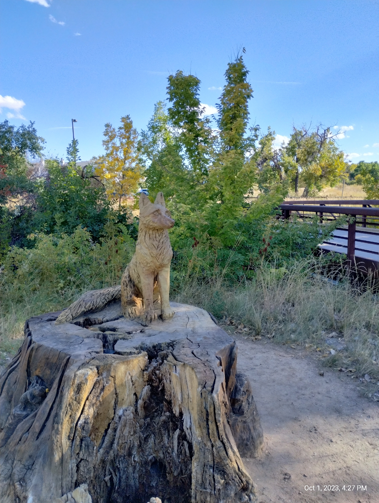
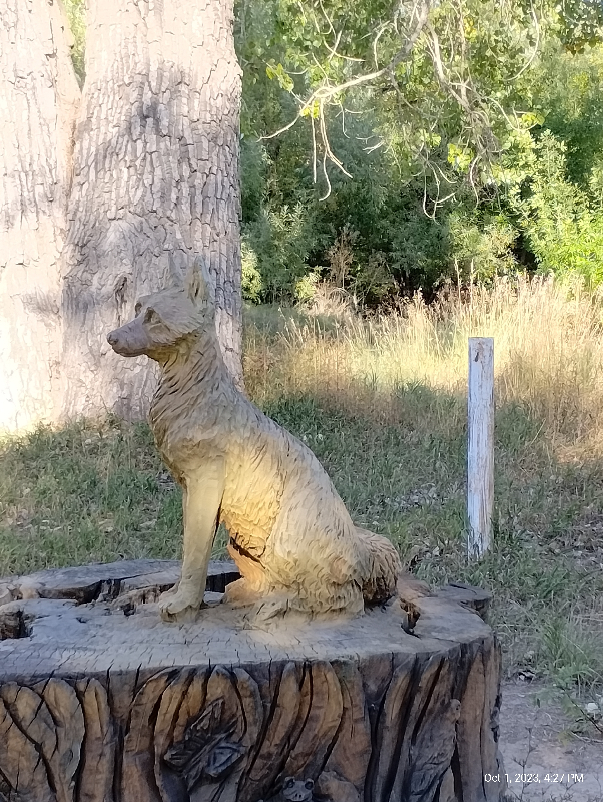
There are chainsaw sculptures at both ends of the aquaduct created by an artists who called herself Chainsawmama. Her real name is Faye Braaten and her work is gorgeous.
The walk from Bible Park to Yale Station isn't long but the end isn't visible until you top a rise between. The Highline Canal is so convoluted that it crosses Yale three times on its way north. That's Mount Morrison and Mount Blue Sky in the distance. The bridges are the Valley Highway (Interstate 25) and the RTD light rail.

There's Yale Station and my destination. I usually approach it from the other side, often shopping at the stores on Colorado Boulevard and my dentist is down the hill, also. I will hike down there for my next station-to-station hike.
Yale affords a lot of good views of the mountains.

One of the grand RTD murals is on the platform wall of Yale Station. 
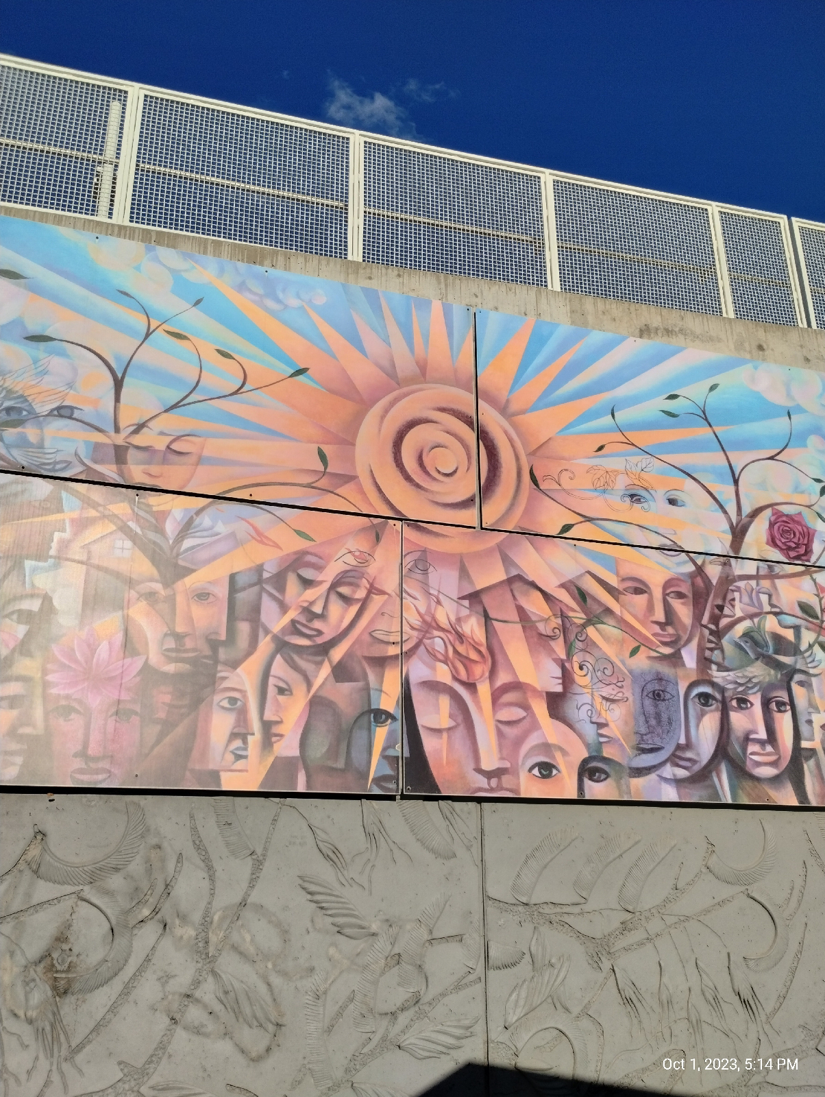
"Connected" was painted by artist Gregory Gove in 2006. 

Sound barriers and walls in this section of the light rail are embossed with what looks to me like a ticket. I'm not sure what they portray but it might be willows, Blue Gramma (the state grass), and/or maybe locust trees. Anyway, your guess is as good as mine.
After finishing my hike, I headed over to Englewood Station and the nearby Walmart to pick up some supplies. By the time I returned to the station, the sun was setting and the cross on Mount Lindo was lit.
It marks a cemetery on one of the mountains near Conifer. I will have to visit it some day. Views from the summit are supposed to be breathtaking.

The next blog will be an anatomy of the Front Range, a long hike that brings it all together. It'll be a long one so the write-up will take some time. See you then.


Thursday, August 29, 2019


--- Highline Canal: Summer ---

Monday the 9th, I hiked about 5 miles of the Highline Canal Trail from Iliff to Alameda. The sundial said 9:40 (I think).


                                                          [Newman Center Sundial]

Earlier this year, I took a much longer stretch of the Highline and decided to avoid any more long hikes during the summer. I'm literally getting too old for that, and I moved away from Alabama to get away from summer heat. I guess global warming is catching up with me.

This stretch of trail is flat out urban. There are urban greenways but I never felt "Wow! It's almost as if  were not in the middle of Denver!" There are some nice distant views of the mountains occasionally. It is pretty obvious that I was putting some distance between me and the Rockies from where I started at Waterton Canyon back in February.

                                                               [Rockies from Iliff]

                                                   [Highline Canal trailhead at Iliff]

This hike had a dual focus. In addition to seeing the trail in summer, I wanted to explore heat on the trail and the next blog will tell you what I found. The trail itself was predominantly green and a little dusty. Most of the flowering plants had gone to seed.

                                                       [The Highline Canal Trail]

The canal itself was dry, as I expected in the middle of summer.

                                                            [The Highline Canal]

Here's the first milepost I came to. The park below offered a much needed rest and toilet.

                                                                     [Milepost 46]

There were a few plants still blooming. Here is a favorite of mine, the prickly poppy. It is prickly, the leaves look like a prickly lettuce, but the blooms look like something else, only bearing a slight resemblance to a poppy.

                                                                [Prickly poppy]

Here's that trailhead at South Quebec. Don't park there overnight, cause the sign.....

                                                         [South Quebec Way Trailhead]

Most of the blooms were bindweed (they are forever), tiny white yarrows, and these golden asters.

                                                                  [Golden Asters]

This section carried me through the monumental (literally) Fairmount Cemetery. Fairmount has beautiful architecture and lots and lots of graves and mausoleums. Some famous people are buried there. Funerary architecture wasn't my focus then but I'll likely want to go back some day when I look at graveyards.


                                                            [Fairmount Cemetery]

Burdocks are the kind of plant that florists prefer when they are dead and dry and there was a considerable number on the Highline.

                                                                  [Line of burdocks]

Colorado, for some reason, doesn't like shade, but there were two of the many benches along this stretch of the Highline that was in the shade. Here's one.

                                                                 [Shady bench]

Despite the recent thinning of the goose population in Denver, there were geese out in Expo Park, which borders Alameda and has two lakes.


                                                        [Geese at Expo Park]

There was a snazzy looking grasshopper on the pavement.


                                                          [Two-striped grasshopper]

Expo Park is near milepost 50 and was my last stop on the Highline Canal. A bus stop was convenient so I took a bus down to the Alameda Station - I had some shopping to do at the Englewood Walmart - and took a train to Englewood Station. The fountains at the Art Walk were inviting, but I passed, wanting to be home at this point. After picking up a few items I took the light rail to University Station and a bus home.

You may or may not prefer urban trails to country hiking but all trails have their charm in every season. It's fun to compare the two - their wildlife and plants, their landscapes, geology, and the people that frequent them.


Monday, June 10, 2019


--- Highline Canal: Spring ---

The Highline Canal Trail is like a highway for pedestrians.

That sounds too much like a metaphor. Let me drop the "like". The Highline Canal Trail is a highway for pedestrians. If you're hiking or biking and you want to get from A to B, then the Highline might be your friend, along with the many other urban trails that intersect it.

Pedestrianism has it's advantages and disadvantages. It's not for the lazy. It's usually slow (barring heavy traffic on the roads)) and takes considerably more effort than driving. It's not going to take you any great distance unless you're going to get into backpacking in a big way.

On the other hand, it's cheap and doesn't rely on fossil fuels. And you get a bonus. All that exercise your doctor prescribes? It's built in.

Exercise. This 17 mile stretch of the Highline pretty much convinced me that I'm getting too old for the 30 mile day hikes I used to do. 20 seems to be my new limit....at least when temperatures rise above 70 degrees.

I joined the Highline Canal Trail near Dry Creek Road in Littleton. There are several access points in the area.


                                                     [Approach to the Highline Canal]

In following the "highline" contour of the area, the canal has to navigate many roads and natural streams by passing over or under. Here is one of the aqueducts over Dry Creek. It's definitely not a Roman aqueduct but it has it's charm in a Currier and Ives way.

                                                                  [Aqueduct]

As an early 20th century work of engineering, it's certainly interesting.

The canal and it's accompanying trail meanders through a wide variety of scenery, including urban shopping areas.

                                                                         [Littleton]

And just to show that I actually did begin near milepost 20, here's milepost 21.

                                                                      [Milepost 21]

Although I was hoping spring wildflowers would be out for the hike (and there was some as I will show), the predominant color was green.

                                                                   [Along the trail]

One of the many walkers I met early on the trail described the trail as "bone dry". As this photo shows, that isn't exactly right. Denver Water allows water to flow along the canal occasionally, but even when it's not flowing, snow melt and rain will produce ponds along the way.

                                                             [Pond on the canal]

There are quite a few vistas of the Rockies along the canal, such as this view of snow capped Mount Evans.

                                                                    [Mount Evans]

One wildflower I encountered was this small white ground cover. I couldn't quite narrow it down but the five petalled flowers and lacy leaves reminded me of an anemone. A good site for wildflower identification in Colorado is Wildflowers of Colorado (http://www.wildflowersofcolorado.com/index.html), which let's you search by flower color and provides lots of photos.

                                                                  [Anemone?]

At one point, the canal crosses Lee Gulch and it's a little difficult to figure out which trail is the Highline Canal and which is the Lee Gulch Trail. Actually, it's not that difficult since the Highline Canal Trail follows the canal....always.

                                                               [Cascade on Lee Gulch]

There are places where the canal really is "bone dry" and you can see the stream bed and how the canal is constructed. Through most of it's length, the Highline flows across natural earth.

                                                                      [Dry bed]

Where there is water, the many foot bridges across the canal provide picturesque scenery.

                                                                        [Footbridge]

I left the trail where it crossed University (the first time) and walked up to Cherry Hills Marketplace for lunch at the Original Pancake House. The food was good and reconnection with the trail was easy. I just followed Orchard Road back down to where it intersected the Highline Canal.

In places honeysuckle splashed that banks of the canal with white, pink, and rose.

                                                                   [Honeysuckle]

These are different honeysuckle than the ones I'm familiar with down South. Those are vines....these are bushes.

I'm especially fond of succulents and cactuses. Their blossoms tend to be extremely varied, intricate, and colorful. Euphorbia is one of the common varieties in this area. It's also called "spurge" There are many species but this green flowered kind is the only kind I've seen locally.

                                                                     [Euphorbia]

These little guys are called Cowboy's Delight or Copper Mallow. They're tiny but the orange blossoms sorta grab you.

                                                           [Copper Mallow plant]

The orange color on this tree trunk is pretty but it is probably a disease called Cytospora Canker.

                                                               [Orange tree trunk]

And this is only the third snake I've seen since I moved to Colorado, all garter snakes (I miss snakes).

                                                                     [Garter snake]

I've hiked the last 7 miles of this stretch of the Highline before. You can see the backyards of some very large homes here. The structures in Cherry Hills Village tend toward the impressive, ornate and large.

By the time I got to Hampden, my feet were blistered, I was tired, and  it was verging on heat-prostration-weather for me, so, after walking down to University, I was ready to hop a bus for the last half mile.

Poetically, spring is the time that nature revives from it's long winter sleep. Actually, nature never sleeps, it's just harder to see what's going on in the winter. But spring is a great time for people who are interested in birds, other wildlife, or flowers. What's happening outside in your area?