Showing posts with label Rocky Mountains. Show all posts

Wednesday, November 8, 2023

University Station to University Station.


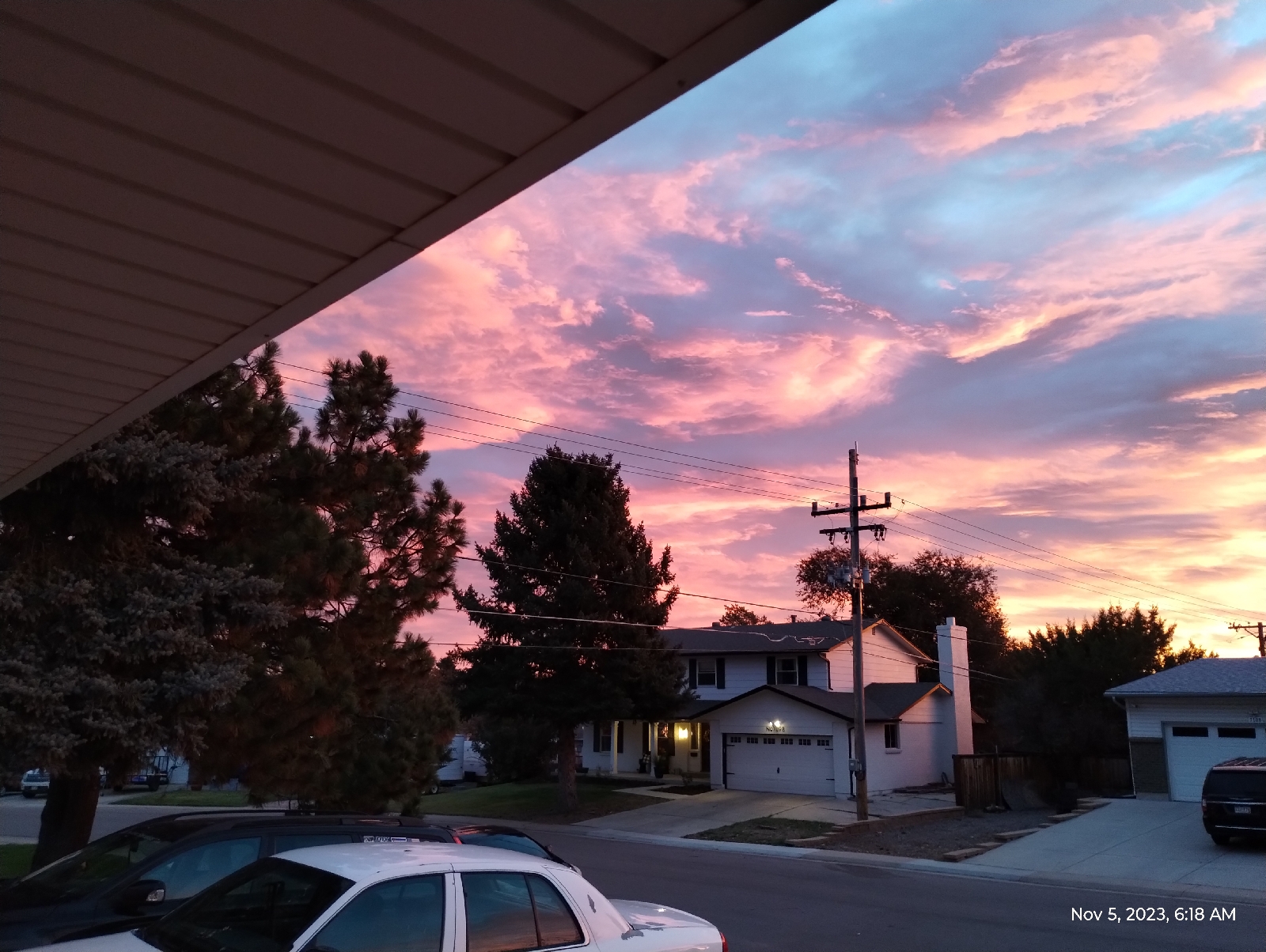
An advantage to getting up early. As badly as it messes up my day if I wake up even a half hour early, it's the only way you catch certain things, these gorgeous sunrises for instance. We're out of the monsoons so things are drying out and there's more particulate matter being stirred up by the autumnal winds. And the later church services at  Christ's Church, Denver start at 10:30 so, to be on time, I need to get up at 6:00 to give my heart medications time to get into my system, and be out at 8:00 in case I have to wait a half hour on the train at Arapahoe Station. 

Since I'm hiking in my old neighborhood around University Boulevard, I decided to visit my old church there. I have friends and many good memories there and am considering returning for an Advent service next month. It's a depressingly rare event. This is only the second time since I moved over three years ago. (I've been there several times, still associated with their library.)
The University campus is always good for a stroll. The building in the foreground, the Cable Building, isn't actually a part of the University, being a monument to the cable industry. It's not immediately apparent how prominent the cable industry is in Denver.

There is that appropriately abstract statue in front of the Cable Building.
But it fits with the powerful and cyclopean aesthetic of the rest of the campus. Here's yet another shot of the Newman Center for the Arts. That's okay....I like the building with it's towers, rose window that actually look like a rose, and sun dial.
Between the college and the residential parts of University Boulevard is a row of high rise apartments.
It's fall and all the non-indigenous plants along the boulevard are in full color.
Cherry Hills is an affluent neighborhood but Christ's Church, in the middle of it all, is a varied mix of a lot of different kinds of people that get along like a family. It's refreshing to experience. It's an Episcopal church but a large proportion of the congregation is Baptist and another is Catholic. Lake Woebegone should take notes.

The emphasis that day was the Feast of All Souls. Many don't realize that Halloween and it's associated All Hallows Day and the Feast of All Souls are not pagan celebrations.... they're Christian from their inception.

Syncretism is almost a human process. If you can't beat them, absorb them. I have no problem with that but I'm necessarily a pagan Christian. Being a werewolf in the church sorta demands it. Syncretism is a fusion of cultures. Halloween is a good example. Many cultures, pagan and Christian, are concerned with people who have died and "gone on". Samhain was (is) one of four seasonal, originally Gaelic festivals marking the end of harvest and beginning of the darker part of the year. It was thought that the boundary between the worlds of the living and the dead was thinnest at this time so celebration of relationships with those who had died including defense against the "dangerous dead" was appropriate.

The natural Christian equivalent was remembrance of departed Christians. Canonized saints were Christians who were exemplary in some way, often martyrdom or the performance of miracles. They had special days of recognition, feast days or other celebrations. But for most parts of the Christian church, all believers are considered saints and recognition of all the saints whose lives are not celebrated by special days occurs at the end of October and the start of November. Halloween is "all hallows evening", the night before All Hallows Day.

It was a good visit. I was surprised that, after over three years absence, so many people would remember me. Of course, these were people who stood by me when a mysterious ailment put me out of operation for a month. A church family is true family.

My favorite "Halloween hymn" is Ralph ("Rafe" not "Ralf") Vaughan Williams' "For all the saints" and that was threaded all through the service. It's as if they knew I would be there. And All Saints' Day isn't just for remembrance of departed friends and family. It's a day of welcoming and baptisms.

Advent Season is coming up and I'll be trying to visit again. By the way, in Orthodox Christianity, Advent comes before Christmas.... they're two different things.

After services, I headed back to the train station with a short stop at the main intersection on campus for a milk shake.
That doesn't look like a very old university but keep in mind that Denver was established in 1861 and there was no city here before 1858 when gold was discovered in Colorado. The Denver isn't much older than the University of Denver.

The requisite shot of the Rockies (heh, that phrase is now in my spell checker)....the last time I took an elevator to the top deck of the RTD parking garage, the mountains were not even visible because of the weather. Here are some more shots from up there 
The Valley Highway (Interstate 25) and University Station.
The campus and more mountains 
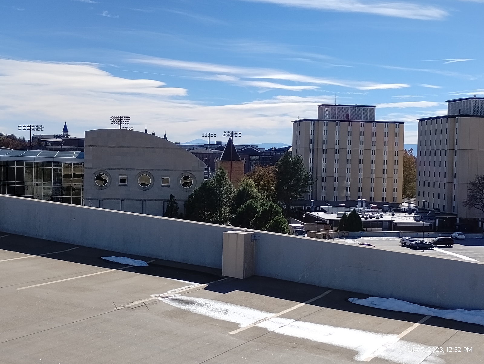
More of the campus and the mountains. If you enlarge the photograph, you can see Pike's Peak just over the end of the (curved) Cable Building.
Across the Interstate toward Washington Park, which will be a destination for my next station-to-station hike. There's also a good view of the Denver skyline.

Back at Village Center (Arapahoe Station) I saw these shiny grasses. Grasses really are underrated as ornamentals, but when you live on the plains, they rise in prominence. I'm going to guess that these are Miscanthus sinensis, or Silver grass.
It's cool how different light so drastically changes the appearance of things.

Are there places in your area that hold a deep significance for you. It's fun to dig deeper and learn more about them. They make good hiking destinations.

Monday, October 16, 2023

Anatomy of a Mountain Range 2: The geological spectacle of Red Rocks


I made these recordings at the Phillips 66 in Morrison at the start of my hike. The weather is holding steady but it's warming up. My sweater has long ago gone into my backpack. The altitude is actually below that of the light rail station at Broadway. That's not surprising since the train station is up above the South Platte River. Morrison is nestled down in the Bear Creek Canyon. I'll be hiking up a lot for awhile.

To the right is the valley cut out by Bear and Mount Vernon Creeks. They flood occasionally so it's a fairly broad area. To the left is the rise to the Rocky Mountains. Here, that would be Mount Morrison and Mount Falcon.
These huge chunks of Fountain formation rock are arkose sandstone. What makes them "arkose" is the large amount of feldspar still in them. What gets eroded out of mountains is usually the constituents of granite - quartz, feldspar, mica, amphiboles, pyroxenes. And small amounts of other stuff. The stuff washed out of the Ancestral Rockies obviously had a lot of dark, iron-bearing minerals such as biotite mica and amphiboles. That's where the red rust comes from when they fall apart chemically. But the feldspar usually goes to clay and quickly gets washed downstream. For there to be feldspar left, the sediments must have been washed out very quickly, deposited close to their source, and buried so that the process of consolidation can begin sooner than later.

There's something else you can see here. Those pockmarks in the rock are called "tafoni" or "honey comb weathering". They're fairly common in desert environments. In really wet places, water just grinds away at rock faces willy-nilly and wears them down large scale. Here, water seeps into the permeable rock and finds weak spots. That's where it starts chemically weathering the stone...in spots.

The sandstone particles are tough because they're cemented together with calcite, but calcite is soluble in acids, and dew and occasional rain is weakly acid from the carbon dioxide it has dissolved. That's how caves form in limestone, which is primarily calcite. In sandstone, the quartz particles (sand) just fall out to form these little holes and horizontal and vertical joints.

The wind and moisture isn't in any hurry to do widespread damage so they can be artistic, carving out these spectacular rock sculptures.
There are a couple of streams in the neighborhood. Bear Creek is a picturesque mountain stream draining the area around Mount Blue Sky. It comes in crashing in from the west having cut out it's canyon. Mount Vernon Creek is a smaller, lazier stream that pours in from the north skirting the edge of the hogback. Most of the streams in Red Rocks Park are like the one shown above...dry until it rains. They're called "draws". This landscape would fit right in with any John Ford western.

Typically, the Fountain formation show up as "standing stones". They look like they were arranged by some giant child marching off into the horizon. Now you know why. They're the shell of the Rocky Mountains, cracked open as the present Rockies were born. Most of the red sandstone on top have long ago been weathered to nothing but there are still some places in the mountains where there are remnants such as Red Rocks Campground, near Woodland Park, west of Pike's Peak.

This is a view south on the Trading Post Trail that runs from a parking lot near the South Entrance to the park to the Trading Post/Rock and Roll Hall of Fame Museum at the base of the amphitheatre.

The lower part of the trail is loose rock and sand deposited by present streams, mostly flooding by Bear Creek, but near the amphitheatre, the flat rock is Fountain formation, giving the hiker an opportunity to see Red Rocks closeup. These ripples are cause by the same weathering that creaked the tefoni in the standing stones.

That's part of the amphitheatre peeking out from behind the little tree. I followed the Trading Post Trail up and around to the grueling stairs up the side of Red Rocks Amphitheatre called the Funicular Trail, which leads to the upper parking lot.

When Red Rocks Park was first built, there was a funicular railroad that carried visitors to the summit of Mount Morrison for a grand view of ...well, everything....mountains, canyon, plains, Red Rocks. To get up there now, you have to hike, but the stairs will get you part way if your knees and lungs hold out.

At the upper parking lot is this...
This is the mystery I promised you at the end of the last blog. At the breadth of a finger is a gap of over a billion years!

It's called the Great Unconformity. The red Rocks on top are the 300 million year old Fountain formation. They sit directly on top of 1.7 billion years old rock of the Idaho Springs formation. What happened in between?

The grayish rock at the bottom is metamorphic gneiss and it's older than the land that would become Colorado. Over a billion years ago a chain of volcanic island crashed into the North American plate and stuck. Rocks like this were lifted with the rest of the Rockies during the Laramie orogeny to become the core of the mountains. 

But what happened to the geologic history of over a billion years? Nobody knows for sure but the most popular answer I find reading about the Great Unconformity is erosion. Something scraped all that accumulated debris off the core rock 400 million years ago. 

Of course, the erosion that formed the Fountain formation razed the Ancestral Rockies to level plains. The sediments above the metamorphic and igneous core of those ancient hills simply washed to the sea. As the hills came down and their slopes leveled out, the sediments were deposited closer and closer (gentler slopes meant slower water currents) until the erosion met granite and gneiss and the sand was laid down right there in what would become Red Rocks Park.

But some geologists find even that to be a weak explanation for the elimination of a billion years of strata.

A tantalizing theory is that the great eraser, glaciers, did it. About that time is when some geologists speculate that Ice covered the Earth, a time they call "the snowball Earth."
West Alameda Parkway begins in Aurora (East Denver Metro) at the Buckley Space Force Base, runs through Denver (one of my favorite shopping areas is around Alameda and Broadway) and ends at the top parking lot of Red Rocks Amphitheatre. In fact, Dinosaur Ridge is a closed off section of Alameda. It passes through a tunnel in a big chunk of the Fountain formation and, not long after, the Plains View Road splits off to the left and leads to the Geological Overlook Trailhead. That looked inviting so I took the bait. It wasn't long before I realized that, if I wanted to make it to Golden before night, I needed to turn back, but before I did, I took a few shorts from a high point (the trail climbs up about a third the distance to the summit of Mount Morrison.) The photo above is one of them.

The two hills in the distance is the mouth of Bear Creek Canyon and just beyond is Bear Creek Lake and Mount Carbon.
This is a view back down to the amphitheatre and Mount Falcon beyond.
Here's some more of that chemical weathering. It gets pretty extensive in some of the areas in Red Rock Park.


A little further north on Alameda Parkway I find the other end of the Geological Overlook Trail and realize that the overlook itself is just off the road, so I take another picture. There's a big sign there that tells you what you're looking at but it was crowded and I try not to get recognizable pictures of people without their permission, so I just got a panorama from the side.

A little more roadwork brought me to Dinosaur Ridge, and that will be the main subject of the next section of Anatomy of a Mountain Range.

Sunday, October 15, 2023

Anatomy of a Mountain Range 1: Morrison


October 8 (it's been awhile but I completed this blog and then it vanished so I had to do it over) I started out as usual for Arapahoe Station. This photo at the junction of Arapahoe and Yosemite shows a clear day that promises good weather for a long, strenuous hike. I wasn't disappointed. The actual hike began two trains, a bus, and a Lyft taxi later.

56 degrees and 53% humidity. Woof! 

I took some measurements to compare with measurements at the start of the hike while I waited for the second train at Broadway Station. The barometric pressure was up and stable. I had a sweater on but it wouldn't stay on for long. 53 degrees is pretty warm for me, given this untempered Colorado sun.

Mount Morrison is front and center. It's the first actual Rocky Mountain near Denver. The rest, Green Mountain, the two Table Mountains, Mount Carbon, the Dakota hogback, Red Rocks, are all foothills.

Here's a closer view from the Wadsworth Park and Ride where I waited for the taxi. Red Rocks Amphitheatre is right there.
The big rock on the right is Creation Rock and the one on the left is Shiprock.....uh, or is it the other way. Honestly, the names have swapped so many times I can't keep up with them. But they are red. The reason they don't look red is that phone cameras add blue to pictures to make them more presentable. Like most red in nature (some exceptions are cinnabar, rubies colored with chromium, cuprite, and red flowers and leaves), Red Rocks are red because of iron, specifically hematite (aka rust).
I usually enter Morrison on the Bear Creek Trail on the south side of Morrison Road, but the taxi let me out at the Phillips 66 on the north side and I noticed that there was a footpath that skirts the base of the road cut, so I took that. It was a good choice for a closeup view of the Dakota hogback.

It's called the Dakota hogback because it's capped with erosion resistant Dakota sandstone. Actually, it's layered with other stuff like this volcanic ash from an ancient volcano far to the south that blew it's top about 100 million years ago. Take note because you'll see it again. The hogback is a star of this hike.

During the Cretaceous period, around 100 to 95 million years ago, an interior seaway opened that split North America in two. Rise of sea level and erosion of gradients to the east and west slowed river flows, for instance, from hills to the west in what is now, Nevada and Utah, causing them to dump fine sediment along their routes and into the inland sea. This compacted to form the sandstones, clays, mudstones, and shales of the Dakota formation. 

These rocks are widespread in North America, from Canada to Mexico and from Iowa to Nevada. These slow moving streams and swampy lowlands were host to a lot of life, big and small, and when that life died, provided an excellent environment for the production of fossils. Dakota rock is a rich source of many of the dinosaur skeletons that grace natural history museums of the United States today.

Climbers were out on the anticline this day. An anticline is a mass of rock that has been folded upward. The Dakota hogback ("hogback" because it reminded someone of the ridge along the back of a wild pig) is the result of the same mountain building event that raised the Rocky Mountains. A little further east, the rocks folded downward forming a big bowl, a syncline, the Denver Basin, that filled in with the sediments from the eroding Rockies. I remember that a syncline is a downward fold because "sync" sounds like "sink" and an anticline is...well, the opposite.

This road cut through the hogback is also the mouth of Bear Creek Canyon which opens up the Rockies back to Evergreen and the area around the base of Mount Blue Sky, third highest mountain in the Front Range. You can see it as the gray mountain in the distance in the photos at the top of this blog. It's gray because the peak is above the timber line, over 14,000 feet. No trees grow in the thin air and top soil up there.

The trail that parallels Morrison Road through the road cut let me out at the eastern border of the busy (always busy) tourist town of "historic Morrison", home of interesting shops and good places to eat. It was too early for my favorite burger place in Morrison, the Mill Street Inn, so I went across the street to The Cow for a milkshake. As I get older, I rarely eat real meals on hikes anymore. I focus on drinks to prevent dehydration. That's a major concern in dry Colorado.
Maple Street, across the road, heads up to Red Rocks Elementary School. I wanted to check out the intersection. Morrison Road passes through town through the mouth of Bear Creek Canyon and turns south there between the hogback and Mount Falcon. (The small but excellent Morrison Natural History Museum, home of what's left of dinosaurs, is down there.) Bear Creek Road branches off west toward Evergreen.

Several formations come together here.

The Dakota formation continues out under Morrison which is built on much younger unconsolidated materials of the Post-Piney Creek and Piney Creek alluviums, material that has been laid down by modern streams, mostly Bear Creek and Mount Vernon Creek, which parallels the hogback to the west.

Just before the intersection, the Lykins formation shows up as brown, iron rich sedimentary rock.

I guess this is a good place to introduce the rules of sedimentary succession. They're pretty intuitive and are important for dating rock....before radioactive dating it, and the identification of certain characteristic fossils, were about all that geologists had to build the geologic time scale.

The Law of Superposition: Younger formations are on top. That makes sense. They were the last sediments to be laid down.

The Law of Original Horizontality: Sediments are initially deposited horizontally. Gravity dictates that. That big anticline in the pictures above was originally flat as a pancake.

The Law of Crosscutting Relationships: If a layer cuts diagonally across rock, the crosscut is more recent. The younger rock cut through rock that was already there.

The Law of Lateral Continuity: If you see a layer in one part of a formation, don't be too surprised if you see it again miles, many miles, down the road in the same formation. It'll be the same layer, the same age.

These principles were first recorded by the 17th century Danish geologist Nicolas Steno, so they're also called Steno's Laws.

The Lykins formation lies atop most of the others in the area (except the debris piled up by the present day creeks) so it's very young by geological standards. About 250 million years old, the Lykins formation shows as a thin band of clay, mudstone, and limestone just west of the Dakota hogback. In places, it's banded, displaying it's only fossils, the sticky algae that were about the only thing that could grow in the muddy swamps of the Permian and Triassic boundary of the region. The Lykins limestone is responsible for many of the few caves in Colorado, like the ones around Manitou Springs near Colorado Springs.

Just west of the Lykins rocks the stone suddenly shifts to the red arkose sandstones of the Fountain Formation that made Red Rocks famous. It also makes up the spectacular scenery of Boulder's Flatirons and the pinnacles of it's Red Rocks Park, the standing stones of Roxborough State Park, Colorado Spring's Garden of the Gods, and even the big rocks scattered around Woodland Park's Red Rocks Campground, west of Pike's Peak. The Maroon Bells on the western slope of the Rockies are also of the Fountain formation.

You see it here as the red stone overlaying harder blonde sandstone. The Fountain formation is around 300 million years old, composed of material washed out of the Ancestral Rockies. It pretty much blanked the area where the older mountains were and when the current Rocky Mountains were uplifted by tectonic forces of the Pacific plate crashing into the North American plate far to the west, the shell of hard sandstone was cracked and pushed skyward, often standing on end.

The blonde sandstone is of the Lyons formation. You can see it in the walls of the buildings of the University of Denver campus in Boulder and the buildings and restraining walls around the Denver Tech Center. The hard sandstone that naturally breaks into sheets is a beautiful, durables, and popular building stone. It's about 280 million years old and....

Wait a minute! Aren't younger stones supposed to lay on top of older stones? 

Well, yeah, generally, but sometimes things get flipped over and then you have to look for an explanation. This one's easy. Like I said, when the Colorado Plateau was uplifted to form the Rockies, it stood the Fountain formation on end, then the inexorable erosion continued working on the new Rockies, actually burying them in their own debris. This stuff formed the Lyons sandstone. Notice the slope of the blonde sandstone. It keeps rising upward until it is above the Fountain formation.

This sharp boundary between very different stones signal a fault. It's not always easy to see faults because they're usually covered by loose soil and alluvium but here it's clear.

Below the Fountain and Lyons formations is a big (big!) surprise. I'll show it to you in the next blog (wait for it!).


Thursday, April 20, 2023

Boulder Canyon

A million years is an inconceivably long time to a human. A billion years is a thousand of those. There are rocks in this area that are 1.7 billion years old (give or take a few.) There have been at least three "Rocky Mountains" in that time.

One Sunday, I took trains and buses up to Boulder, Colorado to look around. As usual, my trip started at Arapahoe at Village Center Station, but that was unremarkable (except very early for me. My body was protesting). The adventure really started here:

in the underground bus terminal at Union Station in Denver. When the original sewers were decommissioned, this part was repurposed for waiting bus patrons. Just about all subsets of humanity (and several subsets of canininity) come through here eventually, so it's a great place to people watch. But there are guards everywhere and they don't want you sitting on the floor. 

I waited about an hour for the Flatiron Flier to Boulder. This is a good route to view the high plains north of Denver. This is mesa country. Sometimes (like driving across Kansas) it's difficult to tell that the plains aren't really flat but it's pretty obvious here where hills like Lake Mesa and Davidson Mass provide plenty of contour. It's all fairly new (less than 2 million years old) sediments washed out of the mountains. Some of the older stuff, called the Laramie formation, around 100 million years old, has been mined for coal near Superior, Colorado. Keep in mind that the Laramie Orogeny, the mountain building event that created the current Rockies, happened between 80 and 35 million years ago. Coal forms from lowland plants in marshy areas. Colorado was low and wet back then. I've spent some time wandering around out there (Wednesday, June 21, 2017, Flatirons Crossing).

I disembarked the bus at Euclid and Broadway, right in front of the Henderson Museum. Just about anywhere in Boulder that trees or buildings don't block the view is a good place to see the Flatirons, named for their resemblance to the domestic contraption. 


They are, in fact, part of the same formation that includes Red Rocks Amphitheater near Denver and the Garden of the Gods in Colorado Springs.

The eastern facade of the Rocky Mountains is well ordered in Colorado. It springs abruptly from the plains and can be seen a hundred miles to the east. It was an imposing and dreadful site to the early pioneers trying for California.

The foothills: Green Mountain, the Table Mountains near Golden, mesas and Mount Carbon, are just stuff that washed out of the rising Rockies (with a few older layers surfacing). The actual wall begins with the (still sedimentary) Dakota hogback. Then the Fountain formation covers the first of the Rockies like a blanket. Then the actual mountains of the Front Range soar skyward.

The Fountain formation used to be horizontal, flat. It was sand laid down by an inland sea between 290 and 340 million years ago, what geologists call the Pennsylvanian age. It was at the edge of the new Rocky Mountains when they were uplifted so they were cracked open and tilted skyward and that is exactly how the slabs of sandstone called "the Flatirons" appear. I'm reminded of the scenes in the movie 2012 as California folded up and toppled into the sea.

But that doesn't seem to be how it was. Judging by studies of stream erosion and other means, the Rockies seemed to be uplifted in three steps, each very slow by human standards. The initial uplift happened between 80 and 50 million years ago. The land rose about a kilometer at the rate of about three hundredths of a millimeter per year...hardly breathtaking. The second stage began about 35 million years ago and continued for about 20 million years. That brought the Rockies up another kilometer and a half at a breakneck speed of six hundredths of a millimeter per year. The last phase of uplift began about five million years ago and is still going on. Come to Colorado and watch the mountains grow! (Heh) This data is from a study published by G. G. Roberts, N. J. White, G. L. Martin-Brandis, and A. G. Crosby entitled "An uplift history of the Colorado Plateau and its surroundings from inverse modeling of longitudinal river profiles" (August 16, 2012, https://doi.org/10.1029/2012TC003107)

Most of the rocks of the Fountain formation are red, gray, or black. The color is from iron that was in the sediments. It rusted, like iron does.

I checked my altitude by GPS at the bus stop in Boulder. It was 1611.44 meters (that's 5287 feet, roughly a mile.) I am gratified at how much better I feel at this height than when I first visited the Denver area.
The Henderson Museum, the University of Colorado's museum of natural history, is a small affair with four rooms of exhibits, some permanent, some changes over time since it is an educational museum with students learning to curate.

There is no admission fee (they do appreciate donations) and there is a lounge with vending machines and places to sit and rest and make notes. One of the permanent collections (shown above) shows mostly local fossils, a wide range of plant, invertebrate, dinosaur, and mammal species. There's also a lot of cultural and historical exhibits, as well as current and historical science.

The building, like many of the cyclopean structures on the University of Colorado campus, is constructed of Lyons sandstone quarried nearby. The material was deposited by an inland sea around 250 million years ago. It's a very tough, fine grained, pretty stone that occurs in horizontal layers that are easy to quarry. See?

After a bite and a milkshake, I caught the NB2 bus up Boulder Creek Canyon to Boulder Falls. I figure NB stands for "Nederland bus" since it runs between Boulder and Nederland, Colorado. (Eh. It might stand for Nederland Boulder. Who knows?)

The Stony heart of the mountains is disclosed here. Boulder Creek has cut right down through it. I took another altimeter reading and found that I was about 2200 meters (7218 feet or about 1.4 miles)  above sea level. That's 589 meters (1932 feet) above Boulder. 
The elevation up there is 7886 feet (according to the topographic map on the AllTrails app.) The creek has cut 668 feet through hard granite. (More actually since "up there" has been worn down considerably over the millennia and the creek was another 20 feet below me.)


The oldest rock in Colorado is a 2.5 billion years old mass of quartzite in the northwestern corner of the state. Colorado was beachfront property near the equator when an arc of volcanic islands crashed into it piling up debris like a pileup on a California turnpike. Later collisions added landmass to what geologists call the "Wyoming Province". This early formed piece of crust, called a craton (Greek for "shield") formed a permanent part of the North American tectonic plate.

About 1.7 billion years ago, a second collision to the south caused widespread melting in the crust that hardened to form the Routt Plutonic Suite, the early core of what would be the Rocky Mountains. That's what one sees here in the Boulder Creek Canyon. Technically, the rock isn't granite. It's granodiorite, but I can't tell the difference. Granite has potassium (orthoclase or microcline) feldspar and granodiorite has sodium (plagioclase or andesite) feldspar. The only way to tell the difference is by thin section microscopy or chemical analysis, neither of which I have access to. But granitic, it definitely is. The photo above shows the white grains of quartz and white and pink feldspar and the dark hornblende clearly. Some of the dark grains are biotite mica.

All the granite is broken into big blocks. It was buried for millennia under thousands of feet of sediments. When the pressure came off through erosion, the rock expanded like a spring and cracked. Water seeped into the cracks and, by repeated freezing and thawing, expanding and melting, wedged the cracks further apart. Eventually, it all goes down into the creek to be washed to the Platte River, then the Mississippi down to the Gulf of Mexico. Chunks of granite erode to rough spheres, thus, "boulders".

The rocks are grainy because they solidified far underground from vast bodies of molten magma where they had plenty of time to form crystals. Molten rock that's ejected onto the surface of the Earth as lava cool quickly and present either a fine grained or glassy texture. I saw several pockets of large crystals of feldspar in the rock walls. The minerals fall out of melt in a definite order and, when they get a chance, will clump together like that. Quartz is the last to solidify. It usually forms the matrix in these grainy igneous rocks.

The rocks in Boulder Canyon are crosscut by numerous faults, veins and dikes. The faults are where large bodies of rock have broken and slide against each other.

Cracks in the rocks serve as conduits for mineral rich waters under high temperature and pressure. They deposit their mineral loads into the cracks to form veins. 

Molten rock flowed into cracks, pushing the solid granite apart and hardening to form dikes of different igneous rock.

Granite carries mica that gives it a flaky texture and when it expands as pressure is taken off by erosion, it sheers off big curved sheets. The process is called "spalling" and it's evident in several places in the canyon.

I didn't really expect much from Boulder Falls. The photographs I've seen portray it as not much more than a cascade. The photographs don't do it justice 

I tried. I think the problem is that the surrounding canyon walls just dwarf the 70 foot torrent from the slot canyon. It's a respectable cataract.

It's also popular so, if you visit, prepare for people watching. The falls are visible from the road. It's a very short hike (with stone steps in the canyon wall and handrails where needed.)

I'm a fanatic for waterfalls, so I think I'll devote a whole blog to them soon.

Having satisfied myself that the bus trip to Boulder Falls was well worth the time and effort, I waited for NB1 on its return route from Nederland and rode as far as Fourmile Canyon. I wanted to do at least a little footwork. 

The Boulder Creek Path runs through the last few miles of Boulder Canyon before it opens out directly into Boulder, Colorado at Eben G. Fine Park. There are signs of human construction there that were probably erased in the big flood of 2013 which destroyed...well, a lot.

The creek gives. It's pretty much why Boulder was established February 10, 1859...gold, of course. And the creek takes away. 2013 wasn't the only disastrous flood ever to roar out of Boulder Canyon. I was in Selma, Alabama at the time but my current family was already in nearby Broomfield, so I watched the news closely. It turned out that they were in no danger.

But the creek has taken a lot more than construction. The front wall of the Rockies...the hogback and Fountain formation have been all but obliterated along the Creek's path. There is a brief area of Dakota sandstone just before the mouth of the canyon. It's not enough to call a hogback.

See the deer?


There is a lot of wildlife in the canyon but this is all I spotted on this Sunday.

There are a few vestiges of the Fountain formation in Red Rocks Park across the creek from Eben Fine.

These are the same kinds of rock sculptures as those in Red Rocks Park in Morrison, Roxborough Park near Littleton, or the Garden of the Gods in Colorado Springs. In fact, there are "red rock" formations that extend through Wyoming and Colorado. If they are a sedimentary blanket that was pushed up by the Colorado uplift, do they appear in areas other than the eastern margin of the Rockies? 

Indeed they do. They form huge rock sculptures near Woodland, Colorado, west of Pikes Peak.

And also show up on the western slopes as the Maroon Bells. 

After a grueling hike up "The Hill" in search of a Flatirons Flier bus stop, I took a long (and welcomed) bus/train ride back home.


I started this blog with inconceivably long periods of time. I guess I should add some caveats and explanations here.

People talk about "Big History", that is, the history of everything from the beginning of the universe to the end and all the reality forming, universe shaking events between. I'm bothered by the term "history" here. In my view, history is "what happened". If it's history, then someone experienced it and recorded it. We have no records of experiences from millions and billions of years ago.

So, why would I say that the Laramie formation is one hundred million years old?

Best guess.

Based on what we know about how the world works, the most cohesive view of "Big History" involves millions of years and lots of trial and error by nature. One way that we have of "knowing" is time measurements by measuring the amount of radioactive elements in an object. For rocks, it's usually uranium or thorium. The isotopes we look at decay so slowly that there will always be some around. But we do know how fast they decay, we know what they change into, and we're pretty sure that we haven't lost or gained any from the beginning. Uranium and thorium are far too heavy for us to lose into space and the amount found in rocks is trapped there. If we gain these heavy elements, say, in meteorites, well, that would mean that the rocks are even older.

Keep in mind that it's not the amount of elements in the rocks that we look at, it's the ratio of their concentration to the concentration of the elements they decay to...or I should say "element" since most of them decay to lead. So once a rock forms, it has the amount of radioactive material it will have trapped in it. As time goes on, the radioactive element decays at a fixed rate. Today, we can check to see how much, say, uranium there is in the rock compared to the amount of lead, and we can calculate the time since it formed.

How old are the rocks in your area. Some people are surprised to find that the Appalachian Mountains in eastern North America are much older than the Rockies. You can learn a lot about your geology from geologic maps of your area. I use an app called Rockd (by Macrostrat Labs at the University of Wisconsin - Madison) to pull up geologic maps and information about local geology in many places worldwide.