When I take a vacation, I devote all of my time to learning about new surroundings...
Wrong!
I enjoy myself, but learning is a part of that. I live within sight of the Rocky Mountains, but I don't get into them that often, so I appreciate what opportunities I get.
Some tribe members came down from Michigan to spend a week in the mountains and our House stayed with them.
The Mosquito Range separates Fairplay, Colorado from Breckenridge. Fact is, we saw one mosquito the whole week and, although Colorado has a diversity of biting flies, there aren't many mosquitoes. I found some of the history of the Mosquitoes here:
But where the name came from...I haven't the foggiest.
The drive from Denver was spectacular, bringing us over Kenosha Pass, but we didn't see any of it because it was night and we were driving through storm clouds.. an adventure in itself. The mountains open up into one of the great high altitude valleys, called parks. Fairplay is in the northwest corner of South Park, and, yes, this is the South Park of television fame/infamy (according to how you like your comedy.) Our destination was in the mountains above Fairplay.
Colorado is tricky. If you were taken from some other part of the world and placed, blindfolded, near Denver, your eyes might tell you that you are somewhere near sea level. The ground is relatively flat. The mountains are right there to the west but an unobstructed view to the east would stretch far. Your lungs would tell you something else because the land actually slopes up from the Mississippi River, over 800 miles away, to Denver, and Denver is a mile over sea level, which means that there is less atmospheric pressure and oxygen.
Fairplay is similar except, ignoring how flat the ground is, Fairplay is almost 10,000 feet above sea level, and even people from Denver might have some difficulty breathing there (I did!)
The Mosquitoes are high peaks. In the twenty miles between Fairplay and Breckenridge are four fourteeners and several other summits above thirteen thousand feet. Our lodge was at a little over ten thousand feet. It was up the side of the valley over the middle fork of the same river that flows through Denver, the South Platte.
The first morning I was at the lodge, I just missed a herd of elk tramping across the property. I missed a lot, but my camera wasn't idle so I'll share what I managed to photograph.
Aspen and evergreens dominated the fall foliage. Aspens are closely related to poplars, in fact, the scientific name for the genus is populus. They like the cold but can survive the short Colorado summers. We have one in our back yard in Centennial.
They are rathers vicious. They secret a toxin that keeps undergrowth from around their roots, which spread out to form other trees. There is a grove of about twenty aspens uphill from the lodge. They are all one tree. Individual trees might live over 100 years but there is a colony in Utah that has a root system estimated to be 80,000 years old.
Crystal Lake Trail carried some of us a few hundred feet above Alma, Colorado, A small town in the Mosquitoes. Alma was getting some snow. We were in the clouds and were getting pelted by blocky, hexagonal crystals of ice called "graupel". We persevered.
We began our 4+ mile trek out in mountane forests of evergreen and aspens but the trees quickly shrank to bushes and brambles. This stuff was all over the place.
My companions asked what it was and I didn't know, so I took a picture and later subjected it to Google Lens. (Although the lodge had WiFi, there was no Internet where we were.) All the willows I had ever seen were trees but, in montane environments, they adapt to form these low, cottony bushes. We were taken by the aromatic leaves.
Willows were one of the early sources of pain relieving salicylates. Modern aspirin is acetylsalicylic acid, but methyl salicylate is the aromatic ester in wintergreen and other salicylates smell good also. The reason for tagging the acetyl group onto salicylate is that the other compounds are rough on stomach linings. Nevertheless, if you have a pain, you can use willow bark or wintergreen tea to get some relief. Just don't overdo it.
We crossed the treeline at around 12,000 feet and none had passed out from a lack of oxygen. One of us was used to diving around the coast of North Carolina before joining us in Colorado and it seems to help. The rest of us were a little out-of-breath. Big trees need more air to thrive than shrubs so they like lower elevations.
Our destination, Crystal Lake (and, by the way, there are at least three Crystal Lakes between Fairplay and Breckenridge. It's easy to get confused.), resides in a scooped out depression in the side of the mountain. It's pretty obvious that there was once a glacier here. These glacial depressions are called "cirques" and the lakes are called "tarns".
What drew people to these mountains was gold that is washed out of the granite by streams and collected in gravels, the gold being heavier than the other stuff in the stream beds. It's called placer mining and the above photo was taken from a mound of rock left by a mining operation. It sloped down to a marshy area that had claimed a Jeep (?!?) and, then, the lake. This place is probably packed with wildflowers in the spring.
The mountains that form the eastern wall of the Rockies can be a scrabble of metamorphic, sedimentary, and igneous rocks, but the Mosquitoes are in the heart of the Rockies and all that has been scraped off by wind, rain, and lots of ice. These are granite mountains.
The Continental Divide runs through here. The waters of the South Platte, running through Fairplay, end up in the Mississippi River and continue to the Gulf of Mexico and, thus, to the Atlantic Ocean. The waters around Breckenridge drain into the Blue River, which is a tributary of the Colorado, so they end up in the Pacific Ocean (well, they would if they were not intercepted for drinking water and irrigation by folks west of here.)
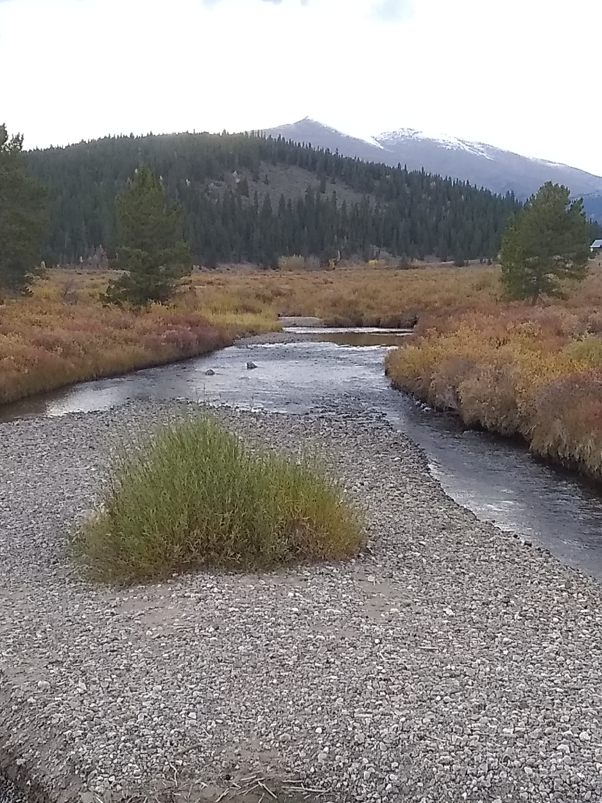
The next day, a few of us walked down to the river below the lodge. Here, the valley carved out by the South Platte broadens as it approaches South Park, itself a wide valley swept out by the South Platte and it's tributaries. The rivers pours out of the hard granite of the Mosquitoes into softer sedimentary rocks of a faulted and folded bowl between the higher mountains. The softer rock allows the river to meander more and more.
The broken thunderstorms afforded us with a nice valley rainbow.
The area is surrounded by several of the local fourteeners, like Mt. Sherman.
It was gravel beds like these that drew pioneers to the area. The granite washed out of the mountains carried with it gold.
These streams are not like the ones I'm used to back east...or the ones where I currently live at the edge of the Great Plains. Those streams have a thick bed of soft material to dig into. The ones in the Rockies meet hard bedrock quickly so their beds tend to be shallow with vertical shoulders.
That night, I pulled out several scopes to look at the sky. The first few days were too cloudy to allow any sky gazing, but we finally got some clear skies and I saw the Milky Way for the first time since the early seventies. It's hard to find dark skies today. But the heart of the galaxy and Orion were low behind the mountain so I didn't try very hard for astrophotographs.
It was a nice week away from the faster pace of Denver.
On the way back to Denver, we pulled over to get a photo of this lady.
I've seen moose tracks around but this is the first moose that I've seen.
I advocate for learning where you are. We lose our anchor in the universe when we don't appreciate our own, personal universe. Every place has it's attractions and values. And it's easier to learn in your back yard. But travel opens new vistas and opportunities.